|
Viewing The Earth from Space
|
||
|
Despite any political differences between the United States and Russia, the space agencies of the two countries continue their cooperative work in Earth's orbit, aboard the International Space Station. Apart from the research being done in microgravity, ISS crew members continue to send back amazing images of our home world, photographed from low Earth orbit. Gathered here are recent images of Earth from aboard the ISS, and from a handful of other NASA satellites.
A fresh apple floats freely near a window in the Cupola of the ISS is featured in this image photographed by an Expedition 38 crew member on February 6, 2014. The bright sun and Earth's horizon provide the backdrop for the scene. (NASA)
This photograph, snapped by an astronaut aboard the ISS on December 12, 2013, shows a white flash of lightning amidst the yellow city lights of Kuwait and Saudi Arabia. (NASA)
One of the Expedition 39 crew members aboard the International Space Station used a 14mm lens on a digital still camera to photograph this pre-winter storm located just off the coast of southwestern Australia on March 29, 2014. A solar array panel on the orbital outpost is in the left side of the frame. (NASA)
This wide field-of-view image photographed by an Expedition 38 crew member on the ISS shows an east-west swath of the southwestern Indian Ocean on January 28, 2014. Two remote islands, part of the French Southern and Antarctic Lands, appear in the center of the image. Possession Island (right center) and East Island (center) are both only 18 kilometers long. A smaller island, Ile aux Cochons (Pigs Island), lies 100 kilometers to the west. Each island has set up V-shaped trains of waves, like bow waves, as the air flows over the islands from the west (right to left). The bow-wave patterns are overlaid on the low regional stratus (blanket) cloud that is so common in the southern Indian Ocean at 50 degrees south latitude. This view was taken from more than 400 kilometers above the sea surface and reveals relationships that could not be readily understood by someone standing on one of the islands. For example, larger and higher islands produce larger waves. So the largest are being generated by Possession Island (934 meters above sea level at the highest point), and East Island, versus much smaller waves developed downwind of the tiny Ile de Pingouins (340 meters above sea level high, invisible below the cloud deck). (NASA)
This sector of the Green River canyon in eastern Utah is known as Bowknot Bend because of the way the river doubles back on itself. In this photograph taken by an astronaut on the ISS on January 22, 2014, the Green River appears dark because it lies in deep shadow, 300 m (1,000 ft) below the surrounding landscape. The yellow-tinged cliffs that face the rising sun give a sense of the steep canyon walls. The straight white line across the scene is the contrail from a jet liner flying over the canyon. (NASA)
On March 30, 2014, the Operational Land Imager on the Landsat 8 satellite captured this image of Nishino-shima, which sits about 1,000 km (600 mi) south of Tokyo in the Ogasawara (Bonin) Island chain. Four months earlier, a new volcanic island emerged just 500 meters offshore of Nishino-shima, and now the two have merged into a single island. (NASA Earth Observatory image by Jesse Allen and Robert Simmon, using Landsat data from the USGS Earth Explorer)
Manhattan, with its long and narrow Central Park easily seen on the right side of the photo, viewed from the ISS on January 9, 2014, photographed by one of the Expedition 38 crew members. (NASA)
An oblique view of the Grand Canyon, from the ISS, on March 25, 2014. (NASA)
The Caribbean country of Cuba is pictured in this image, photographed by one of the Expedition 38 crew members aboard the ISS, on December 26, 2013. (NASA)
Lake Sharpe near Lower Brule, South Dakota is featured in this image photographed by an Expedition 38 crew member aboard the ISS on December 26, 2013. The Missouri River, in places, has many meander bends such as this, occupied by Lake Sharpe, an approximately 130-km (80 mi) long reservoir formed behind the Big Bend Dam. The lake surface is frozen and covered with snow, which also highlights circular agricultural fields on the small peninsula within the meander bend. This type of field indicates center-pivot irrigation, where water is distributed from a central point radially outwards using sprinklers to cover the field area. (NASA)
One of the Expedition 38 crew members aboard the ISS recorded this image of the Manicouagan Crater and reservoir located primarily in Manicouagan Regional County Municipality in Quebec, Canada, on January 2, 2014. Scientists believe the crater was caused by the impact of a 5 km (3 mi) diameter asteroid about 215.5 million years ago (Triassic Period). The crater is a multiple-ring structure about 100 km (60 mi) across, with its inner ring as its most prominent feature; it contains a 70 km (40 mi) diameter annular lake, the Manicouagan Reservoir, surrounding an inner island plateau, Rene-Levasseur Island. (NASA)
A set of NanoRacks CubeSats is photographed by an Expedition 38 crew member after the deployment by the NanoRacks Launcher attached to the end of the Japanese robotic arm on February 25, 2014. The CubeSats program contains a variety of experiments such as Earth observations and advanced electronics testing. A blue and white part of Earth provides the backdrop for the scene. (NASA)
The Operational Land Imager (OLI) on Landsat 8 captured this view of an alluvial fan in Kazakhstan's Almaty province on September 9, 2013. The Tente River flows through a narrow channel in the foothills of the Dzungarian Alatau range. Where the Tente emerges from the hills near Lake Alakol, it spreads out and becomes a braided stream. The movement of the channel over time has left a large fan that's about 20 km (12 mi) across at its widest point. (NASA Earth Observatory image by Jesse Allen and Robert Simmon, using Landsat data from the U.S. Geological Survey. Caption by Adam Voiland)
The moon, above the Earth's limb, seen from the ISS on February 21, 2014. (Koichi Wakata/NASA)
Islands of the Four Mountains are featured in this image photographed by an Expedition 38 crew member on the ISS on November 15, 2013. Morning sunlight illuminates the southeast-facing slopes of the islands in the photograph. The islands, part of the Aleutian Island chain, are actually the upper slopes of volcanoes rising from the sea floor; Carlisle, Cleveland, Herbert, and Tana. (NASA)
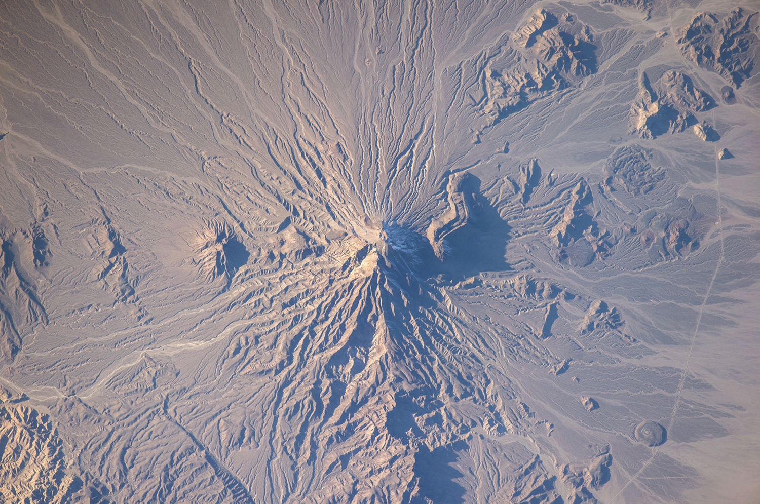
Bazman volcano in Iran is featured in this image photographed by an Expedition 38 crew member aboard the ISS on January 5, 2014. Bazman volcano is located in a remote southern region within the Bazman Protected Area of Sistan and Baluchestan Provinces. While the volcano has the classic cone shape associated with stratovolcanoes, it is also heavily dissected by channels that extend downwards from the 3,490-meter-above-sea-level summit. This radial drainage pattern - looking similar to the spokes of a bicycle wheel - is readily observed in this photograph. Such patterns can form around high, symmetric peaks when water runoff and erosion is not constrained by the resistance of geologic materials or barriers to flow, leading to essentially even distribution of water runoff channels around the central peak. (NASA)
March 27, 2014 -- A view from the ISS shows the Soyuz TMA-12M spacecraft shortly before docking of the two orbiting vehicles. (NASA)
The Soyuz TMA-11M spacecraft drifts Earthward with Expedition 39 Commander Koichi Wakata of the Japan Aerospace Exploration Agency (JAXA), Soyuz Commander Mikhail Tyurin of Roscosmos, and Flight Engineer Rick Mastracchio of NASA, near the town of Zhezkazgan, Kazakhstan on May 14, 2014. Wakata, Tyurin and Mastracchio returned to Earth after more than six months aboard the ISS. (NASA/Bill Ingalls)
Haze and clouds above Malaysia, seen from the ISS on March 13, 2014. (NASA)
The Soyuz TMA-11M spacecraft lands near the town of Zhezkazgan, Kazakhstan on May 14, 2014. (NASA/Bill Ingalls)
Expedition 39 Commander Koichi Wakata is helped of the Soyuz Capsule just minutes after he and Soyuz Commander Mikhail Tyurin, and Rick Mastracchio of NASA, landed in their Soyuz TMA-11M spacecraft in Kazakhstan on May 14, 2014. (NASA/Bill Ingalls)
|
||
|
|
|
|
| ← Previous picture Next picture → | ||
|
Military Woman Gallery
Must See Places |
||
|
|
||