Loading...
Done
Underground River

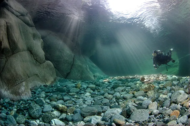
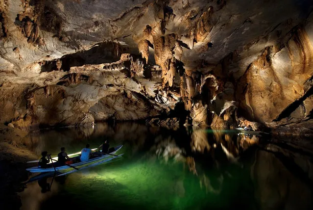
The Puerto Princesa Subterranean River National Park is located about 50 kilometres (30 mi) north of the city centre of Puerto Princesa, Palawan, Philippines. The river is also called Puerto Princesa Underground River. The national park is located in the Saint Paul Mountain Range on the northern coast of the island. It is bordered by St. Paul Bay to the north and the Babuyan River to the east. The City Government of Puerto Princesa has managed the National Park since 1992. The park is also known as St. Paul's Subterranean River National Park, or St. Paul Underground River. The entrance to the Subterranean River is a short hike from the town of Sabang.
Details
16 Jul 2012 11:37:00
Children stand in a boat at the banks of the polluted Yamuna River during a dust haze as they wait to give a ride to worshippers in New Delhi during World Environment Day June 5, 2010. (Photo by Reinhard Krause/Reuters)

Children stand in a boat at the banks of the polluted Yamuna River during a dust haze as they wait to give a ride to worshippers in New Delhi during World Environment Day June 5, 2010. (Photo by Reinhard Krause/Reuters)
Details
10 Oct 2014 12:50:00
Ground personnel work next to the Soyuz TMA-13M capsule of the International Space Station (ISS) crew of Alexander Gerst of Germany, Maxim Suraev of Russia and Reid Wiseman of the U.S. after its landing near the town of Arkalyk in northern Kazakhstan November 10, 2014. (Photo by Shamil Zhumatov/Reuters)

Ground personnel work next to the Soyuz TMA-13M capsule of the International Space Station (ISS) crew of Alexander Gerst of Germany, Maxim Suraev of Russia and Reid Wiseman of the U.S. after its landing near the town of Arkalyk in northern Kazakhstan November 10, 2014. A veteran Russian cosmonaut and two International Space Station crewmates, one from the United States and one from Germany, returned safely to Earth on Sunday with a parachute landing of their Soyuz capsule in Kazakhstan, ending 5-1/2 months in orbit. (Photo by Shamil Zhumatov/Reuters)
Details
10 Nov 2014 13:58:00
A pheasant stands in snow near Dulverton

A pheasant stands in snow near Dulverton on January 30, 2012 on Exmoor, England. After unseasonably mild winter weather, some parts of the UK woke to a covering of snow as a cold spell of weather sets in, with forecasters warning temperatures are set to plunge as the week progresses. (Photo by Matt Cardy/Getty Images)
Details
31 Jan 2012 11:14:00
An angler fishes on the opening day of the salmon fishing season on the River Tay at Kenmore in Scotland, Britain January 16, 2017. (Photo by Russell Cheyne/Reuters)

An angler fishes on the opening day of the salmon fishing season on the River Tay at Kenmore in Scotland, Britain January 16, 2017. (Photo by Russell Cheyne/Reuters)
Details
17 Jan 2017 12:18:00
Crystal Clear Waters Of Verzasca River

The Verzasca is a Swiss 30-km long mountain river originating at Pizzo Barone and flowing into Lake Maggiore. It is known for its clear turquoise water and vibrant colored rocks, as well as its treacherous currents. The Verzasca Dam is a few kilometers upriver from this lake.
Details
16 Oct 2013 10:59:00
Dragon Bridge Over The River Hang

The Dragon Bridge (Vietnamese: Cầu Rồng) is a bridge over the River Hàn at Da Nang, Vietnam. Construction of the bridge began on 19 July 2009 (the same day as the inauguration of the nearby Thuận Phước Bridge) when the Prime Minister of Vietnam Nguyen Tan Dung and many high-ranking government officials attended the groundbreaking ceremony. Dragon Bridge is 666m long, 37.5m wide and has six lanes for traffic. It opened to traffic on March 29, 2013, at a cost os nearly VND 1.5 trillion dong (US$88m). The bridge was designed by the US-based Ammann & Whitney Consulting Engineers with Louis Berger Group. Construction was undertaken by Company No. 508, an affiliate of Civil Construction Engineering Corporation No.5, and Bridge Company No. 75.
Details
01 Jan 2014 08:41:00
These pictures look like an artist has painted abstract patterns on canvas – but in fact they are natural rivers captured on camera. The spectacular rivers in Iceland's central highlands and southern parts originate from glaciers, which is why the water is a milky colour. (Photo by Andrey Ermolaev/Solent News)

These picture look like an artist has painted abstract patterns on canvas – but in fact they are natural rivers captured on camera. The spectacular rivers in Iceland's central highlands and southern parts originate from glaciers, which is why the water is a milky colour. They are shallow rivers and the water spreads quickly over a flat and sandy surface, creating random and beautiful patterns. Photographer Andrey Ermolaev from Moscow, Russia, flew 500ft above the unique sight in a small plane. (Photo by Andrey Ermolaev/Solent News)
Details
05 May 2014 10:57:00