Loading...
Done
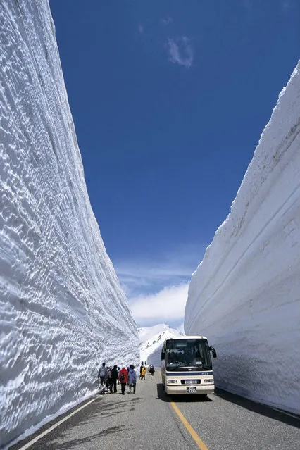
Snow Wall in Japan

The Tateyama Kurobe Alpine Route is an international mountain sightseeing route some 90 kilometers (56 miles) long. The route goes across the 3,000-meter-high North Alpine mountains, the so-called “roof of Japan,” and connects Toyama and Shinano Omachi. You can enjoy the panorama by taking a train, highland bus, trolley bus, cable car, and ropeway. Since the lines opened in June 1971, the Tateyama mountain area has been transformed from an isolated spot into one of the nation’s best sightseeing areas, where a million guests visit every year.
Details
27 Jul 2012 09:28:00
In this photograph taken on December 8, 2017, Indian child Samarth Bangari, 2, plays with langur monkeys at his home in Allapur in India' s southwest Karnataka state. (Photo by Manjunath Kiran/AFP Photo)

In this photograph taken on December 8, 2017, Indian child Samarth Bangari, 2, plays with langur monkeys at his home in Allapur in India' s southwest Karnataka state, 250 miles from Bangalore. He is still too young to talk, but a 2- year- old Indian boy has become a subject of local intrigue after befriending a gang of langur monkeys. (Photo by Manjunath Kiran/AFP Photo)
Details
25 Dec 2017 06:03:00
Young Lebanese women wearing protective masks and gloves against the coronavirus pandemic, stand on August 5, 2020 amid the rubble in Beirut's Gimmayzeh commercial district which was heavily damaged by the previous day's powerful explosion that tore through Lebanon's capital, resulting from the ignition of a huge depot of ammonium nitrate at the city's main port. Rescuers searched for survivors in Beirut after a cataclysmic explosion at the port sowed devastation across entire neighbourhoods, killing more than 100 people, wounding thousands and plunging Lebanon deeper into crisis. The blast, which appeared to have been caused by a fire igniting 2,750 tonnes of ammonium nitrate left unsecured in a warehouse, was felt as far away as Cyprus, some 150 miles (240 kilometres) to the northwest. (Photo by AFP Photo/Stringer)

Young Lebanese women wearing protective masks and gloves against the coronavirus pandemic, stand on August 5, 2020 amid the rubble in Beirut's Gimmayzeh commercial district which was heavily damaged by the previous day's powerful explosion that tore through Lebanon's capital, resulting from the ignition of a huge depot of ammonium nitrate at the city's main port. Rescuers searched for survivors in Beirut after a cataclysmic explosion at the port sowed devastation across entire neighbourhoods, killing more than 100 people, wounding thousands and plunging Lebanon deeper into crisis. The blast, which appeared to have been caused by a fire igniting 2,750 tonnes of ammonium nitrate left unsecured in a warehouse, was felt as far away as Cyprus, some 150 miles (240 kilometres) to the northwest. (Photo by AFP Photo/Stringer)
Details
10 Aug 2020 00:05:00
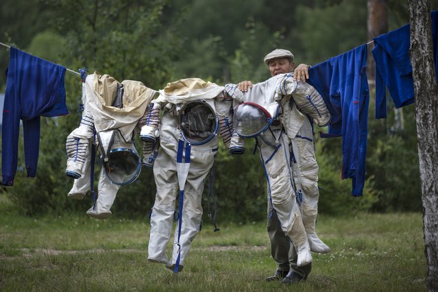
An employe of Russian Space Training Center hangs out to dry space suits of Russian cosmonaut Anatoly Ivanishin, NASA's U.S. flight engineer Kathleen Rubins, and Japanese space agency's flight engineer Takuya Onishi, right, after their undergoing  training near in Noginsk, 60 km (38 miles) east of Moscow, Russia, Wednesday, July 2, 2014. (Photo by Alexander Zemlianichenko/AP Photo)

An employe of Russian Space Training Center hangs out to dry space suits of Russian cosmonaut Anatoly Ivanishin, NASA's U.S. flight engineer Kathleen Rubins, and Japanese space agency's flight engineer Takuya Onishi, right, after their undergoing training near in Noginsk, 60 km (38 miles) east of Moscow, Russia, Wednesday, July 2, 2014. The training was intended to simulate the capsule landing on water. Russian cosmonaut Anatoly Ivanishin, Japanese space agency's flight engineer Takuya Onishi, and NASA's U.S. flight engineer Kathleen Rubins are being trained for a future mission to the International Space Station. (Photo by Alexander Zemlianichenko/AP Photo)
Details
05 Jul 2014 11:47:00
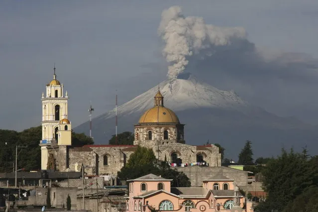
The main church in the town of San Damian Texoloc, Mexico stands in front of the Popocatepetl volcano as is spews ash and vapor early Tuesday, July 9, 2013. Last Saturday, Mexico's National Center for Disaster Prevention raised the volcano alert from Stage 2 Yellow to Stage 3 Yellow, the final step before a Red alert, when possible evacuations could be ordered after the Popocatepetl volcano spit out a cloud of ash and vapor 2 miles (3 kilometers) high over several days of eruptions. (Photo by J. Guadalupe Perez/AP Photo)

The main church in the town of San Damian Texoloc, Mexico stands in front of the Popocatepetl volcano as is spews ash and vapor early Tuesday, July 9, 2013. Last Saturday, Mexico's National Center for Disaster Prevention raised the volcano alert from Stage 2 Yellow to Stage 3 Yellow, the final step before a Red alert, when possible evacuations could be ordered after the Popocatepetl volcano spit out a cloud of ash and vapor 2 miles (3 kilometers) high over several days of eruptions. (Photo by J. Guadalupe Perez/AP Photo)
Details
10 Jul 2013 08:45:00
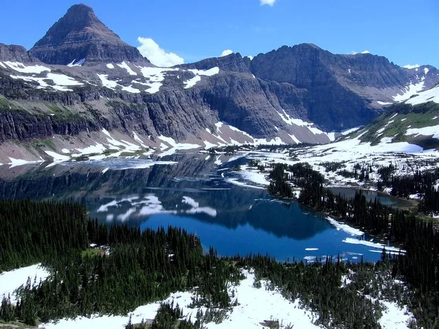
Glacier National Park Montana

Glacier National Park is a national park located in the U.S. state of Montana, on the Canada–United States border with the Canadian provinces of Alberta and British Columbia. The park encompasses over 1,000,000 acres (4,000 km2) and includes parts of two mountain ranges (sub-ranges of the Rocky Mountains), over 130 named lakes, more than 1,000 different species of plants and hundreds of species of animals. This vast pristine ecosystem is the centerpiece of what has been referred to as the "Crown of the Continent Ecosystem", a region of protected land encompassing 16,000 square miles (41,000 km2).
Details
29 Oct 2013 11:13:00
A girl struggles with winds from approaching Typhoon Matmo along the eastern coast of Keelung, northeastern Taiwan, Tuesday, July 22, 2014. The eye of Typhoon Matmo is expected to make landfall in eastern Taiwan early Wednesday bringing heavy rain and winds with gusts over 130 kilometers (85 miles) per hour. (Photo by Wally Santana/AP Photo)

A girl struggles with winds from approaching Typhoon Matmo along the eastern coast of Keelung, northeastern Taiwan, Tuesday, July 22, 2014. (Photo by Wally Santana/AP Photo)
Details
05 Aug 2014 12:46:00
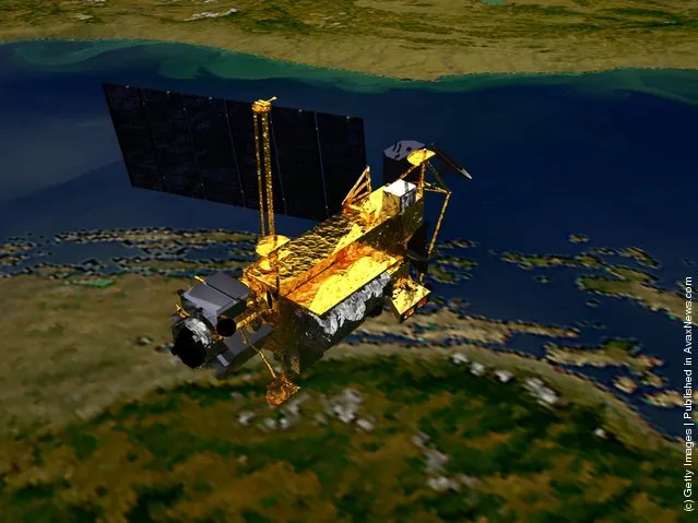
Upper Atmosphere Research Satellite (UARS)

In this artist illustration handout from the National Aeronautics and Space Administration (NASA), the Upper Atmosphere Research Satellite (UARS) is seen. According to NASA, the 12,500 pound satellite will fall from orbit into earth's atmosphere anytime between September 22 through 24. It is estimated that the space craft will break up into about 100 pieces, with an estimated 26 of which could hit the earth over a possible 500 mile debris field. (Illustration by NASA via Getty Images)
Details
21 Sep 2011 10:49:00