Loading...
Done
Salt ponds in San Francisco Bay

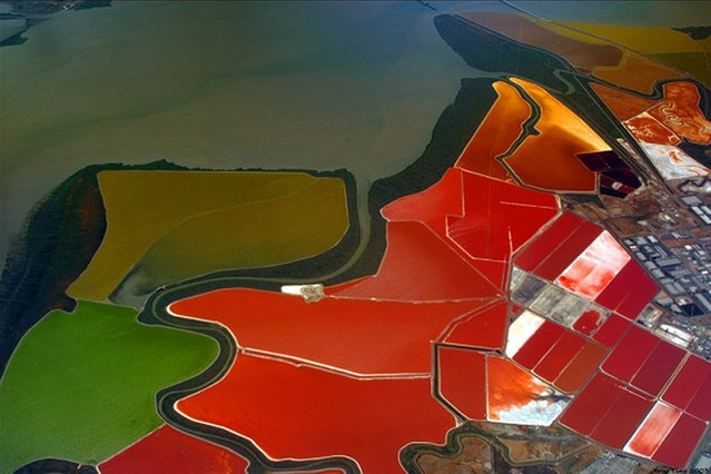
Salt evaporation ponds, also called salterns or salt pans, are shallow artificial ponds designed to produce salts from sea water or other brines. The seawater or brine is fed into large ponds and water is drawn out through natural evaporation which allows the salt to be subsequently harvested. The ponds also provide a productive resting and feeding ground for many species of waterbirds, which may include endangered species. The ponds are commonly separated by levees.
Details
11 Oct 2012 12:49:00
Hurricane Irene

In this handout GOES satellite image provided by the National Oceanic and Atmospheric Administration (NOAA), Irene reaches hurricane strength as it moves across Puerto Rico towards Hispaniola August 22, 2011 in the Caribbean Sea. Irene, the first hurricane of the Atlantic storm season, brought torrential rains and winds to Puerto Rico, downing trees and powerlines and flooding streets. The expected path will bring Irene through the Bahamas and is likely to hit Florida and up the east coast of the U.S. (Photo by NOAA via Getty Images)
Details
23 Aug 2011 12:47:00
Blackpool Tower

A visitor tries out the new glass Skywalk at the top of the refurbished Blackpool Tower on September 1, 2011 in Blackpool, England. After a GBP Ј20 million refurbishment, the iconic seaside Blackpool Tower opened today to the general public. The observation deck at the top of the tower becomes the Blackpool Tower Eye and features a skywalk made of glass overlooking the sea and the promenade. The opening is part of Blackpool's GBP Ј250 million GBP regeneration project. (Photo by Christopher Furlong/Getty Images)
Details
02 Sep 2011 11:07:00
Oil Pumping From Rena Continues

The stern of the stranded cargo vessel Rena grounded on the Astrolabe Reef is seen on October 20, 2011 in Tauranga, New Zealand. Salvage crews continue to pump oil off the ship in an effort to remove as much as possible before bad weather predicted for the evening threatens to break the vessel and release more oil into the sea. Over 300 tonnes of oil has leaked from Rena since it hit the reef on October 5. (Photo by New Zealand Defence Force via Getty Images)
Details
20 Oct 2011 09:11:00
Tugboats haul the “Disney Fantasy” cruise ship backwards down Ems river after the ship departed from the Meyer Werft shipyards

An onlooker watches as the “Disney Fantasy” cruise ship is hauled backwards by a tugboat down the Ems River after the ship departed from the Meyer Werft shipyards on January 20, 2012 in Papenburg, Germany. The completed 130,000-tonne ship, which is 1,115 feet long and can accomodate 5,450 passengers, cast and crew, was on its way to the North Sea. (Photo by Sean Gallup/Getty Images)
Details
05 Feb 2012 12:56:00
Revelers celebrate during fireworks marking the start of the New Year on Copacabana beach on January 1, 2017 in Rio de Janeiro, Brazil. (Photo by Mario Tama/Getty Images)

Revelers celebrate during fireworks marking the start of the New Year on Copacabana beach on January 1, 2017 in Rio de Janeiro, Brazil. Brazilian revelers traditionally dress in white to honor the New Year's holiday along with the Brazilian Goddess of the Sea- Iemanja. (Photo by Mario Tama/Getty Images)
Details
02 Jan 2017 12:59:00
Salar de Uyuni

Salar de Uyuni (or Salar de Tunupa) is the world's largest salt flat at 10,582 square kilometers (4,086 sq mi). It is located in the Potosí and Oruro departments in southwest Bolivia, near the crest of the Andes, and is elevated 3,656 meters (11,995 ft) above mean sea level. The Salar was formed as a result of transformations between several prehistoric lakes. It is covered by a few meters of salt crust, which has an extraordinary flatness with the average altitude variations within one meter over the entire area of the Salar.
Details
04 Aug 2012 08:42:00
Kaindy Lake in Kazakhstan

Kaindy Lake (Kazakh: Қайыңды көлі, Qayındı köli) is a 400 metre long lake in Kazakhstan that reaches depths near 30 metres in some areas. It is located 129 km ESE of the city of Almaty and is 2,000 metres above sea level. It was created by the result of an enormous limestone landslide, triggered by the 1911 Kebin earthquake. The track to Kaindy lake has many scenic views to the Saty Gorge, the Chilik River valley and the Kaindy Gorge. Dried-out trunks of submerged Picea schrenkiana trees rise above the surface.
Details
06 Aug 2012 09:58:00