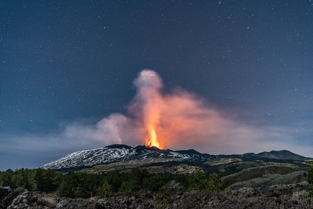
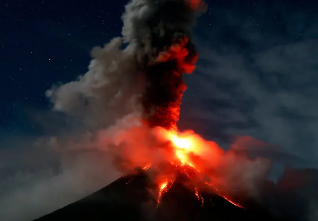
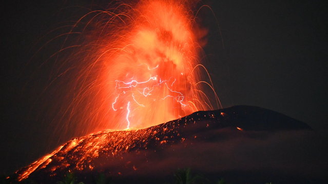
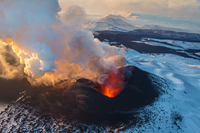
Loading...
Done
Mexico Wave. (Photo by Kenji Croman/Caters News)

“One talented photographer has managed to capture these jaw-dropping images that show off the beauty of the surf and the art hidden in the waves. Kenji Croman has a deep passion for bodyboarding and photography and was inspired to combine the two after growing up in Hawaii”. – Caters News. (Photo by Kenji Croman/Caters News)
Details
19 Sep 2014 09:56:00
A surfer comes free from her surfboard. (Photo by Sarah Lee/Caters News)

Underwater photographer Sarah Lee uses a technique known as “duck diving” to capture these stunning photos of surfers in Hawaii. Surfers “duck dive” under the water to avoid incoming waves so they can get further out to sea. Photo: A surfer comes free from her surfboard. (Photo by Sarah Lee/Caters News)
Details
24 Jun 2013 12:37:00
Nyiragongo Crater

Mount Nyiragongo is an active stratovolcano On the Virunga Mountains associated with the Albertine Rift. It is located inside Virunga National Park, in the Democratic Republic of the Congo, about 20 km (12 mi) north of the town of Goma and Lake Kivu and just west of the border with Rwanda. The main crater is about two km wide and usually contains a lava lake.
Details
08 Aug 2013 12:38:00


In this handout image provided by the National Oceanic and Atmospheric Administration (NOAA), model runs from the Center for Tsunami Research at the NOAA Pacific Marine Environmental Laboratory show the expected wave heights of the tsunami as it travels across the Pacific basin March 11, 2011. The largest wave heights are expected near the earthquake epicenter, off Japan. The wave will decrease in height as it travels across the deep Pacific but grow taller as it nears coastal areas. In general, as the energy of the wave decreases with distance, the near shore heights will also decrease (e.g., coastal Hawaii will not expect heights of that encountered in coastal Japan). (Photo by NOAA via Getty Images)
Details
13 Mar 2011 14:29:00


A Haka is performed before the ceremonial departure of the 'vaka' or traditional canoes ahead of their cross-Pacific voyage from Viaduct Harbour on April 13, 2011 in Auckland, New Zealand. Powered by sun and wind only, the 15,000 nautical mile journey to Hawaii via French Polynesia will set off on April 15, aiming to raise awareness of environmental issues such as ocean noise pollution, acidification and anoxic waters, whilst recapturing traditional Pacific voyaging. The votyage is named “Te Mana o Te Moana” meaning “The Spirit of the Sea”. (Photo by Phil Walter/Getty Images)
Details
13 Apr 2011 07:45:00
A farmer seen harvesting his crops while Mount Sinabung spewing out volcanic ash on July 4, 2017 in North Sumatera, Indonesia. The increased volume of lava dome that reaches one million eight hundred cubic meters, said volcanologist, through radio communications, do not dampen the activities of the people around sinabung, such as farming, harvesting their crops, picking up objects that are still left behind, or just take a picture while walking around near mount Sinabung. (Photo by Sabirin Manurung/Pacific Press/Barcroft Images)

A farmer seen harvesting his crops while Mount Sinabung spewing out volcanic ash on July 4, 2017 in North Sumatera, Indonesia. The increased volume of lava dome that reaches one million eight hundred cubic meters, said volcanologist, through radio communications, do not dampen the activities of the people around sinabung, such as farming, harvesting their crops, picking up objects that are still left behind, or just take a picture while walking around near mount Sinabung. (Photo by Sabirin Manurung/Pacific Press/Barcroft Images)
Details
06 Aug 2017 07:50:00
Take a look at this stunning photo of Tolbachik, an active volcanic complex on the Kamchatka Peninsula in far eastern Russia. Lava fountains and rivers ran through the area for months after the eruption began with the opening of two Tolbachik fissures in November of 2012. In the midst of this activity, photographers Luda and Andrey (lusika33) took a trip down to see that stunning hell valley on earth. (Photo by lusika33)

Take a look at this stunning photo of Tolbachik, an active volcanic complex on the Kamchatka Peninsula in far eastern Russia. Lava fountains and rivers ran through the area for months after the eruption began with the opening of two Tolbachik fissures in November of 2012. In the midst of this activity, photographers Luda and Andrey (lusika33) took a trip down to see that stunning hell valley on earth. (Photo by lusika33)
Details
21 Jul 2014 11:09:00
Black Rock Desert

The Black Rock Desert is an arid region of lava beds and playa, or alkali flats, situated in the Black Rock Desert-High Rock Canyon Emigrant Trails National Conservation Area, a silt playa 100 miles north of Reno that encompasses more than 300,000 acres of land and contains more than 120 miles of historic trails. It is in the northern Nevada section of the Great Basin with a lakebed that is a dry remnant of Pleistocene Lake Lahontan.
Details
22 Mar 2013 11:01:00