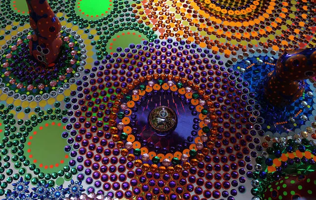
Loading...
Done
All In By Graham MacIndoe

In order to get a glimpse into the visual culture of drug trade in New York City, a British photographer Graham MacIndoe collected more than one hundred bags, which were used to sell heroin. These bags feature references to various movies, fast-food restaurants, and luxury brands. This could be a way to mark various purities of heroin, or maybe different drug dealers use different markers to distinguish between each other. We can only wonder where Graham has acquired all these heroin bags. Hopefully, he picked them up after their contents were emptied. (Photo by Graham MacIndoe)
Details
01 Dec 2014 14:15:00
Drawing By Karl Bang

Karl Bang's paintings are unique because he combines totally different styles of painting within the same format. It is very difficult to design a balanced composition with realistic elements that are juxtaposed with flat colors and patterns. The faces of his subjects are painted realistically in the Western tradition with subtle gradations of color; while, his figures and costumes vignette into abstracted shapes, lines, flat colors and patterns that reflect Karl's background in China. It is as though there are different visual languages being spoken within his paintings.
Details
30 Jul 2013 09:16:00
Christopher Jonassen’s Alien Landscapes

Is it the surface of the Mars or Venus or an undiscovered planet? Not at all. These pictures aren’t what you think they are. Christopher Jonassen, a Norwegian photographer shot these beautiful and otherworldly series called ‘Devour of frying pan bottoms’, which are visually similar to craters and scars on a planet’s surface. In his series Jonassen refers to a quote of Jean-Paul Satre who said: ‘To eat is to appropriate destruction’ and the meaning of the word ‘devour’, which stands for eating up greedily, destroying, consuming, and wasting.
Details
30 Aug 2013 08:18:00
Stop the Violence, Don’t Speed Ad Campaign

The ‘Stop the Violence’ advertising campaign by Brazilian agency Terremoto Propaganda aims to reduce the risk of accidents on the road. The visually grabbing print campaign shows a vehicle painted on the face of one person and the fist of another, drawing the comparison between what is widely known to be intentional violence, such as punching someone in the face, with what many incorrectly consider unintentional, like speeding or unsafe lane changes. Let us know what you think about this campaign in the comments below.
Details
01 Apr 2014 12:29:00
“Basement”. (Photo by Joshua Hoffine/The Washington Post)

Joshua Hoffine, based in Kansas City, Mo., and a self-proclaimed “Horror Photographer”, is interested in the psychology of fear. In his project “After Dark, My Sweet”, Hoffine’s surreal and staged images render these fears visible with the “visual grammar of a child”. Through elaborate sets, costumes, makeup and fog machines, Hoffine’s children act out these terrifying scenes in front of his camera. Here: “Basement”. (Photo by Joshua Hoffine/The Washington Post)
Details
29 Oct 2016 11:47:00
Laura Paipo (L), first blind principal in Uruguay participates in a street race with her sighted guide and friend Amparo Bauter in Montevideo, October 4, 2015. (Photo by Andres Stapff/Reuters)

Laura Paipo (L), first blind principal in Uruguay participates in a street race with her sighted guide and friend Amparo Bauter in Montevideo, October 4, 2015. Paipo, 55, who took office on August 10, 2015 became the first blind principal of a special school which specializes in the education of visually impaired students. (Photo by Andres Stapff/Reuters)
Details
08 Oct 2015 08:00:00
From Britain to China to Mali, new maps showing travel times to the nearest urban centre reveal huge differences between countries. Using Open Street Map and Google, a University of Oxford team have created a visual breakdown that suggests major inequalities when it comes to commuting. Here: China. The dataset used for China was unique as it relied solely on Open Street Map, due to restrictions on accessing Google data. The population is densely concentrated in the east and accessibility is increased, whereas rural provinces in the west remain remote. (Photo by Daniel Weiss/Jennifer Rozier/Malaria Atlas Project/University of Oxford )

From Britain to China to Mali, new maps showing travel times to the nearest urban centre reveal huge differences between countries. Using Open Street Map and Google, a University of Oxford team have created a visual breakdown that suggests major inequalities when it comes to commuting. Here: China. The dataset used for China was unique as it relied solely on Open Street Map, due to restrictions on accessing Google data. The population is densely concentrated in the east and accessibility is increased, whereas rural provinces in the west remain remote. (Photo by Daniel Weiss/Jennifer Rozier/Malaria Atlas Project/University of Oxford)
Details
12 Jan 2018 06:43:00
Robert Rickhoff  By "Out Of Place"

German artist Robert Rickhoff re-interprets the idea of public space with humor through a series of digitally manipulated photographs in a project entitled “out of place”. Rickhoff augments scenes within a seemingly commonplace environment to depict impractical yet lighthearted situations – including a playground slippery dip facing towards a busy road to a speed bump placed in an unassuming residential street that is actually a daredevil ramp. the visualizations are subtle yet provocative, forcing the audience to look twice to notice the unusual setting infused with tongue-in-cheek wit.
Details
17 Feb 2013 11:43:00