Loading...
Done


“The Crimean War (October 1853 – February 1856) was a conflict fought between the Russian Empire and an alliance of the French Empire, the British Empire, the Ottoman Empire, and the Kingdom of Sardinia. The war was part of a long-running contest between the major European powers for influence over territories of the declining Ottoman Empire. Most of the conflict took place on the Crimean Peninsula, but there were smaller campaigns in western Anatolia, Caucasus, the Baltic Sea, the Pacific Ocean and the White Sea”. – Wikipedia

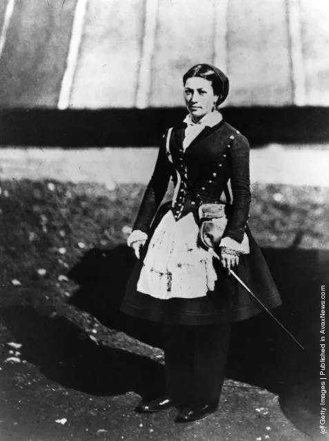
Photo: A vivandiere, a female soldier selling provisions and spirits, with the Allied forces during the Crimean War. (Photo by Hulton Archive/Getty Images)
Details
18 Jul 2011 11:57:00
A train drives along a field at a salt production site at the Sasyk-Sivash lake near the city of Yevpatoria, Crimea, November 14, 2017. (Photo by Pavel Rebrov/Reuters)

A train drives along a field at a salt production site at the Sasyk-Sivash lake near the city of Yevpatoria, Crimea, November 14, 2017. A saltwater lagoon known as Lake Sasyk-Sivash on Ukraine's Crimea peninsula is the source of a rare resource: pink salt. The mineral is tinted by tiny algae that produce the pigment beta-carotene. Each autumn, seasonal workers collect thousands of tons of pink salt for processing and export. (Photo by Pavel Rebrov/Reuters)
Details
16 Nov 2017 08:18:00
Corinth Canal

The Corinth Canal is a canal that connects the Gulf of Corinth with the Saronic Gulf in the Aegean Sea. It cuts through the narrow Isthmus of Corinth and separates the Peloponnesian peninsula from the Greek mainland, thus effectively making the former an island. The builders dug the canal through the Isthmus at sea level; no locks are employed. It is 6.4 kilometres (4.0 mi) in length and only 21.3 metres (70 ft) wide at its base, making it unpassable for most modern ships. It now has little economic importance.

Details
12 Mar 2013 12:21:00
A couple takes a photo outside the MUJA (Jurassic Museum of Asturias) in Colunga, northern Spain, November 6, 2015. (Photo by Eloy Alonso/Reuters)

A couple takes a photo outside the MUJA (Jurassic Museum of Asturias) in Colunga, northern Spain, November 6, 2015. The scientific team of the Jurassic Museum of Asturias (MUJA) presents their latest studies on the fossil of a Ichthyosaur, which acccording to them is the most complete found in the Iberian Peninsula and one of the few in the world. (Photo by Eloy Alonso/Reuters)
Details
09 Nov 2015 08:00:00
A girl with Russian national flags painted on her cheeks takes part in celebrations marking the first anniversary of Russia's annexation of Crimea, in central Simferopol March 16, 2015. (Photo by Maxim Shemetov/Reuters)

A girl with Russian national flags painted on her cheeks takes part in celebrations marking the first anniversary of Russia's annexation of Crimea, in central Simferopol March 16, 2015. Russia marks one year anniversary of annexation of Ukraine's Crimea peninsula this week. (Photo by Maxim Shemetov/Reuters)
Details
18 Mar 2015 11:30:00
Cenote In Mexico

A cenote is a natural phenomenon, a sinkhole in the Earth’s surface. The Yucatan Peninsula in Mexico has an estimated 7,000 cenotes because it is primarily made up of porous limestone. For millions of years, rainfall slowly ate away at the limestone and a huge system of underground caves and caverns was formed. Many filled with water from rain or from the underground water table. When the roof of a water filled cave collapses, a cenote is born. The water found in a cenote may be fresh water, salt water, or both. Structurally it may be completely open, like a lake, almost completely closed with just a small opening at the top, or somewhere in between.
Details
06 Oct 2013 09:45:00
The underground entrance to the volcano resembles a scene from the latest Hobbit movie. (Photo by Denis Budkov/Caters News)

Taken by photographer, Denis Budkov, 33, the Plosky Tolbachik is one of a cluster of volcanoes located in the Kamchatka Peninsula in the far east of Russia. After taking a lucky group of tourists to the crater of the flat volcano, the Russian photographer managed to get less than 300 metres away from the spurting jets of lava. Photo: The underground entrance to the volcano resembles a scene from the latest Hobbit movie. (Photo by Denis Budkov/Caters News)
Details
08 Jan 2014 10:46:00
The Atlantic Road, Norway

The Atlantic Ocean Road or the Atlantic Road (Norwegian: Atlanterhavsveien) is a 8.3-kilometer (5.2 mi) long section of County Road 64 that runs through an archipelago in Eide and Averøy in Møre og Romsdal, Norway. It passes by Hustadvika, an unsheltered part of the Norwegian Sea, connecting the island of Averøy with the mainland and Romsdalshalvoya peninsula. It runs between the villages of Karvag on Averoy and Vevang in Eida. It is built on several small islands and skerries, which are connected by several causeways, viaducts and eight bridges – the most prominent being Storseisundet Bridge.
Details
18 Jan 2014 11:42:00