Sea of clouds is seen after a rainfall at the Huangshan Mountain scenic spot on April 10, 2019 in Huangshan, Anhui Province of China. (Photo by Fang Lihua/Qianlong.com/VCG via Getty Images)
A villager harvests water chestnuts in Feijiadai Village, Zhejiang Province, China on September 20, 2019. (Photo by Huang Zongzhi/Xinhua News Agency/Barcroft Media)
Buildings in Lujiazui financial district are seen shrouded in fog amid an orange alert for heavy fog in Shanghai, China on January 31, 2024. (Photo by Xihao Jiang/Reuters)
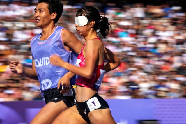
Shanshan He, of China, competes at Women's 1500 -T11 at the Stade de France stadium, during the 2024 Paralympics, Sunday, September 1, 2024, in Paris, France. (Photo by Emilio Morenatti/AP Photo)
Jolie from China, who says she is afraid of the sun, stands near the Colosseum amid a heatwave in Rome, Italy on June 20, 2024. (Photo by Guglielmo Mangiapane/Reuters)
A Chinese girl dressed in Qing Dynasty attire takes photographs of another near the Forbidden city in Beijing, China, Sunday, July 21, 2024. (Photo by Vincent Thian/AP Photo)
Farmers feed crabs under Metasequoia at the Sihong County Ecological Breeding Base in Suqian City, Jiangsu Province, China, on November 19, 2025. (Photo by Costfoto/NurPhoto/Rex Features/Shutterstock)
From Britain to China to Mali, new maps showing travel times to the nearest urban centre reveal huge differences between countries. Using Open Street Map and Google, a University of Oxford team have created a visual breakdown that suggests major inequalities when it comes to commuting. Here: China. The dataset used for China was unique as it relied solely on Open Street Map, due to restrictions on accessing Google data. The population is densely concentrated in the east and accessibility is increased, whereas rural provinces in the west remain remote. (Photo by Daniel Weiss/Jennifer Rozier/Malaria Atlas Project/University of Oxford)