Loading...
Done
Oresund Bridge

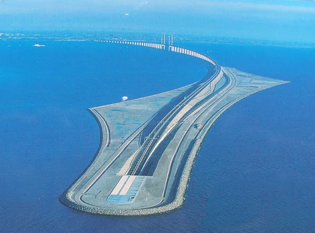
The Öresund or Øresund Bridge is a double-track railway and dual carriageway bridge-tunnel across the Øresund strait between Scania (southernmost Sweden) and Denmark. The bridge runs nearly 8 km (5 miles) from the Swedish coast to the artificial island of Peberholm, which lies in the middle of the strait. The remainder of the link is by a 4 km (2.5 mile) tunnel from Peberholm to the Danish island of Amager. The Øresund Bridge is the longest combined road and rail bridge in Europe, and connects two major metropolitan areas: Copenhagen, the Danish capital city, and the major Swedish city of Malmö. It connects the road and rail networks of Scandinavia with those of Central and Western Europe.
Details
10 Sep 2013 11:23:00
A photo taken on July 22, 2017 shows beach- goers dancing at the West Sea Barrage beach outside the coastal city of Nampo, southwest of Pyongyang. (Photo by Ed Jones/AFP Photo)

A photo taken on July 22, 2017 shows beach- goers dancing at the West Sea Barrage beach outside the coastal city of Nampo, southwest of Pyongyang. The West Sea Barrage beach features as a stopping point for foreign tourists, and is a destination for North Korean work groups from the neighbouring area. The beach lies at the end of an eight- kilometre- long barrage that separates the sea from the Taedong River, which runs through Pyongyang. (Photo by Ed Jones/AFP Photo)
Details
04 Aug 2017 09:09:00
The carcass of a yacare caiman lies in the dried-up river bed of the Pilcomayo river in Boqueron, Paraguay, August 14, 2016. In Paraguay, alongside the Pilcomayo River, black vultures flew over a shrinking pond where a group of crocodilian reptiles known as yacare caimans sought refuge. Water from the river, which divides Paraguay and Argentina in the area of the Gran Chaco, was scarce. This is not an uncommon sight in the region of General Diaz, about 700 kilometres (435 miles) northwest of the country's capital Asuncion, where the Pilcomayo's waters form lakes and streams that give life to capybaras, birds and caimans. “The river's situation is critical. No water is forecast to enter the basin until December, as happens every year”, said Alcides Gonzalez, a resident of the area. (Photo by Jorge Adorno/Reuters)

The carcass of a yacare caiman lies in the dried-up river bed of the Pilcomayo river in Boqueron, Paraguay, August 14, 2016. In Paraguay, alongside the Pilcomayo River, black vultures flew over a shrinking pond where a group of crocodilian reptiles known as yacare caimans sought refuge. Water from the river, which divides Paraguay and Argentina in the area of the Gran Chaco, was scarce. This is not an uncommon sight in the region of General Diaz, about 700 kilometres (435 miles) northwest of the country's capital Asuncion, where the Pilcomayo's waters form lakes and streams that give life to capybaras, birds and caimans. (Photo by Jorge Adorno/Reuters)
Details
03 Nov 2016 12:40:00
Lake Assal Crater Lake In The Central Djibouti

Lake Assal is a crater lake in central-western Djibouti. It is located at the western end of Gulf of Tadjoura in the Tadjoura Region, touching Dikhil Region, at the top of the Great Rift Valley, some 120 km (75 mi) west of Djibouti city. Lake Assal is a saline lake which lies 155 m (509 ft) below sea level in the Afar Triangle, making it the lowest point on land in Africa and the third-lowest land depression on Earth after the Dead Sea and Sea of Galilee.
Details
15 Jul 2015 10:19:00
China Celebrates The Year Of The Dragon Spring Festival

Chinese folk artists perform the lion dance at a temple fair to celebrate the Lunar New Year of Dragon on January 22, 2012 in Beijing, China. Falling on January 23 this year, the Chinese Lunar New Year, also known as the Spring Festival, which is based on the Lunisolar Chinese calendar, is celebrated from the first day of the first month of the lunar year and ends with Lantern Festival on the Fifteenth day. (Photo by Feng Li/Getty Images)
Details
23 Jan 2012 10:13:00
A rainbow arcs over a girl on the platform of Stadion station. (Photo by Conor MacNeill/The Observer)

Beneath the Swedish capital lies an intricate web of underground train lines. More than 90 of the 100 stations in the 110km tunnel system, sometimes referred to as “the world’s longest art gallery”, have been decorated with paintings, installations, mosaics and sculptures by 150 artists since the 1950s. After spending a couple of weeks exploring arctic Norway and Sweden, London-based travel photographer Conor MacNeill headed underground to capture images of the metro stations. Here: A rainbow arcs over a girl on the platform of Stadion station. (Photo by Conor MacNeill/The Observer)
Details
05 Jun 2016 13:21:00
A tourist take a photograph of a sulphur lake in the Danakil Depression on January 23, 2017 near Dallol, Ethiopia. (Photo by Carl Court/Getty Images)

A tourist take a photograph of a sulphur lake in the Danakil Depression on January 23, 2017 near Dallol, Ethiopia. The depression lies 100 metres below sea level and is one of the hottest and most inhospitable places on Earth. Despite the gruelling conditions, Ethiopians continue a centuries old industry of mining salt from the ground by hand in temperatures that average 34.5 degrees centigrade but have risen to over 50 degrees. (Photo by Carl Court/Getty Images)
Details
25 Jan 2017 11:36:00
The Majesty Of Norway's Dalsnibba Mountain

Dalsnibba is a mountain in Stranda Municipality in More og Romsdal county, Norway. It is located at the end of the Geiranger valley, about 21 kilometres (13 mi) south of the village of Geiranger and the Geirangerfjorden. The 2-square-kilometre (0.77 sq mi) lake Djupvatnet lies directly to the southeast of the mountain. The mountain is located very near the county border with both Oppland and Sogn og Fjordane counties, in the southeastern part of Møre og Romsdal county.
Details
24 Jul 2013 10:28:00