Loading...
Done
Mount Roraima

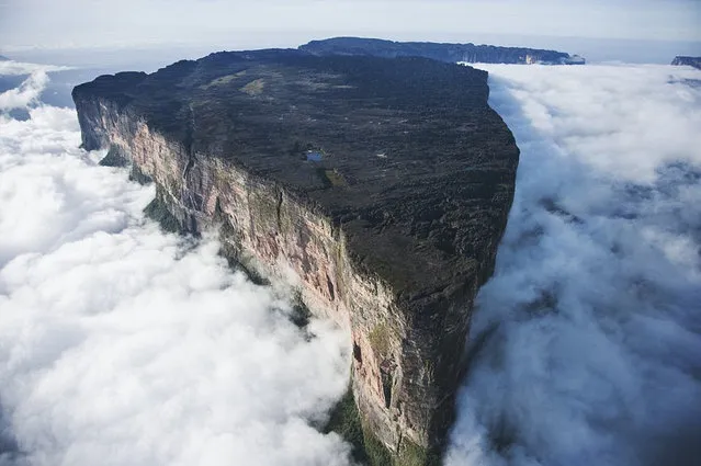
Mount Roraima (Spanish: Monte Roraima, also known as Tepuy Roraima and Cerro Roraima; Portuguese: Monte Roraima [ˈmõtʃi ʁoˈɾajmɐ]) is the highest of the Pakaraima chain of tepui plateau in South America. First described by the English explorer Sir Walter Raleigh in 1596, its 31 km2 summit area is defended by 400-metre-tall cliffs on all sides. The mountain includes the triple border point of Venezuela, Brazil and Guyana.
Details
11 Sep 2012 08:04:00
A mahout watches the Thai animation movie Kan Kluay with his elephant in Ayuthaya province, about 80km (49 miles) north of Bangkok June 5, 2006. The movie tells the story of a young Thai wild elephant who, while looking for his father, becomes the war elephant of the Thai King fighting against Burma and restored Thailand's ancient Ayuthaya empire that existed about 400 years ago. (Photo by Sukree Sukplang/Reuters)

A mahout watches the Thai animation movie Kan Kluay with his elephant in Ayuthaya province, about 80km (49 miles) north of Bangkok June 5, 2006. The movie tells the story of a young Thai wild elephant who, while looking for his father, becomes the war elephant of the Thai King fighting against Burma and restored Thailand's ancient Ayuthaya empire that existed about 400 years ago. (Photo by Sukree Sukplang/Reuters)
Details
12 Aug 2015 13:33:00
View of colourful rock formations at the Zhangye Danxia Landform Geological Park in Gansu Province, China. The Zhangye Danxia Landform Geological Park is 40km from Zhangye city. The park spans more than 400 square kilometers in Gansu. The unusual terrain is the result of red sandstone and mineral deposits carved over the years by natural forces. A number of boardwalks have been built to encourage visitors to explore the rock formations. (Photo by ImagineChina/The Grosby Group)

View of colourful rock formations at the Zhangye Danxia Landform Geological Park in Gansu Province, China. The Zhangye Danxia Landform Geological Park is 40km from Zhangye city. The park spans more than 400 square kilometers in Gansu. The unusual terrain is the result of red sandstone and mineral deposits carved over the years by natural forces. (Photo by ImagineChina/The Grosby Group)
Details
02 Dec 2013 09:12:00
Villagers look on as Mount Sinabung volcano spews thick volcanic ash, as seen from Beganding village in Karo, North Sumatra province, on May 19, 2017. Sinabung roared back to life in 2010 for the first time in 400 years. After another period of inactivity, it erupted once more in 2013 and has remained highly active since. (Photo by Ivan Damanik/AFP Photo)

Villagers look on as Mount Sinabung volcano spews thick volcanic ash, as seen from Beganding village in Karo, North Sumatra province, on May 19, 2017. Sinabung roared back to life in 2010 for the first time in 400 years. After another period of inactivity, it erupted once more in 2013 and has remained highly active since. (Photo by Ivan Damanik/AFP Photo)
Details
20 May 2017 10:09:00
A pile of road salt

Route engineer Richard Winter stands in front of a pile of road salt at the Birchanger Depot on November 8, 2011 near Bishop's Stortford, England. (Photo by Peter Macdiarmid/Getty Images)
Details
10 Nov 2011 09:52:00
Wrecked tanks are seen close to the road that leads to the village of Imber on Salisbury Plain, England

Wrecked tanks are seen close to the road that leads to the village of Imber on December 31, 2011 on Salisbury Plain, England. (Photo by Matt Cardy/Getty Images)
Details
03 Jan 2012 13:34:00
A vehicle lies on a road in Adairsville. (Photo by David Goldman/Associated Press)

A vehicle lies on a road in Adairsville. (Photo by David Goldman/Associated Press)
Details
02 Feb 2013 10:48:00
Labourers who work nearby nap on a road as cars drive past in Chongqing Municipality, July 23, 2013. (Photo by Reuters/Stringer)

Labourers who work nearby nap on a road as cars drive past in Chongqing Municipality, July 23, 2013. (Photo by Reuters/Stringer)
Details
05 Sep 2013 10:28:00