Loading...
Done
Butchart Gardens - British Columbia, Canada

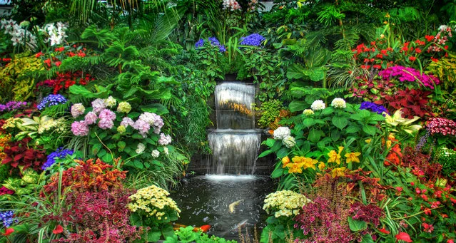
The Butchart Gardens is a group of floral display gardens in Brentwood Bay, British Columbia, Canada, located near Victoria on Vancouver Island. The gardens receive close to a million visitors each year. The gardens have been designated a National Historic Site of Canada due to their international renown.
Details
27 Apr 2014 09:33:00
Photographing Polar Bears By Paul Souders

American nature and wildlife photographer Paul Souders is very well-travelled around the globe. In one of his exploits, we have his series of images shot in the ice capped shores of Churchill, Canada. Souders took his Zodiac boat to Hudson Bay in midsummer and waited there for three days before he finally saw a bear, a young female while on sea ice around 30 miles offshore.
Details
29 Aug 2014 13:52:00
A Hindu holy man on his way to the annual holy dip at Gangasagar, gestures towards a visitor as he rests at a transit camp in Kolkata, India, Wednesday, January 6, 2016. (Photo by Bikas Das/AP Photo)

A Hindu holy man on his way to the annual holy dip at Gangasagar, gestures towards a visitor as he rests at a transit camp in Kolkata, India, Wednesday, January 6, 2016. Thousands of Hindu pilgrims are expected to take the annual holy dip at Gangasagar, where the Ganges River reaches the Bay of Bengal, on the auspicious Makar Sankranti festival day that falls on Jan.14. (Photo by Bikas Das/AP Photo)
Details
10 Jan 2016 08:06:00
Split Apple Rock

Split Apple Rock is a geological rock formation in The Tasman Bay off the northern coast of the South Island of New Zealand. Made of granite, it is in the shape of an apple which has been cut in half. It is a popular tourist attraction in the waters of the Tasman Sea approximately 50 metres off the coast between Kaiteriteri and Marahau. The rock sits in shallow water at low tide and is accessible by wading. It is also a point of interest for the many tourist boats and pleasure craft which operate along the shores of the Abel Tasman National Park. The cleft to produce two sides of the 'apple' was a natural occurrence. It is unknown when this happened and therefore the cleaving of the rock has attracted mythological explanations.
Details
19 Oct 2013 10:58:00
The Great Dismal Swamp

The Great Dismal Swamp is a marshy area in the Coastal Plain Region of southeastern Virginia and northeastern North Carolina, between Norfolk, Virginia, and Elizabeth City, North Carolina. It is located in parts of southern Virginia cities Chesapeake and Suffolk and northern North Carolina counties Gates, Pasquotank and Camden. It is a southern swamp, one of many along the Atlantic Ocean's coast, including the Everglades and Big Cypress Swamp in Florida, the Okefenokee Swamp in Georgia, the Congaree and Four Holes swamps of South Carolina, and some of the Carolina bays in the Carolinas and Georgia. Along the eastern edge runs the Dismal Swamp Canal, completed in 1805.
Details
09 Dec 2013 11:40:00
Metal Cats By Alexandra Crockett

Alexandra Crockett, a musician and jewelry designer, has been present and active in the metal community since the age of 15 and is currently a doctoral student in the Bay Area. Beginning her idea for the book by doing promotional photos for bands and friends she would cat-sit for, she found an interesting dynamic between men in the metal scene and their cats. The idea for the book formed around giving accolades to local musicians and artists in the metal scene, while also bringing to light no-kill shelters and their importance for animal rights.
Details
08 Sep 2014 08:47:00
A car rolls south along the Dalton Highway near Coldfoot, Alaska, USA, 03 September 2017. (Photo by Jim Lo Scalzo/EPA)

A car rolls south along the Dalton Highway near Coldfoot, Alaska, USA, 03 September 2017. Stretching 414 miles (666 kilometers) north from central Alaska to Prudhoe Bay, the Dalton Highway is one of America's northernmost roads and arguably its most remote. (Photo by Jim Lo Scalzo/EPA)
Details
09 Oct 2017 08:01:00
Underground River

The Puerto Princesa Subterranean River National Park is located about 50 kilometres (30 mi) north of the city centre of Puerto Princesa, Palawan, Philippines. The river is also called Puerto Princesa Underground River. The national park is located in the Saint Paul Mountain Range on the northern coast of the island. It is bordered by St. Paul Bay to the north and the Babuyan River to the east. The City Government of Puerto Princesa has managed the National Park since 1992. The park is also known as St. Paul's Subterranean River National Park, or St. Paul Underground River. The entrance to the Subterranean River is a short hike from the town of Sabang.
Details
16 Jul 2012 11:37:00