Loading...
Done
Industrial Sector, Tokai, Japan. (Photo by Benjamin Grant/Digital Globe/Caters News)

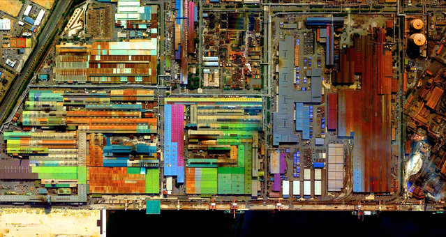
This series of pictures shot by satellite, show the man-made world as astronauts see it. Artist Benjamin Grant uses Google Earth to find the most compelling satellite images of human civilization. The stunning pictures of sprawling metropolises and vast reservoirs are sometimes unidentifiable until zoomed in. In order to find an extraordinary picture in the practically endless supply of satellite data, Benjamin focuses on the themes of current events or environmental issues. Here: Industrial Sector, Tokai, Japan. (Photo by Benjamin Grant/Digital Globe/Caters News)
Details
04 Feb 2015 12:21:00
Schoolchildren attend their first lesson on Knowledge Day in the town of Turov, Zhytkavichy District, Gomel Region, Belarus on September 1, 2017. Knowledge Day marks the beginning of a new school year in Belarus and is celebrated on September 1. (Photo by Viktor Drachev/TASS via Getty Images)

Though schools around the globe have different start dates, calendars and traditions, the first day of a new term is an exciting time filled with the prospects of gaining more knowledge, making new friends and building community. Here: Schoolchildren attend their first lesson on Knowledge Day in the town of Turov, Zhytkavichy District, Gomel Region, Belarus on September 1, 2017. Knowledge Day marks the beginning of a new school year in Belarus and is celebrated on September 1. (Photo by Viktor Drachev/TASS via Getty Images)
Details
20 Sep 2017 08:00:00
From Britain to China to Mali, new maps showing travel times to the nearest urban centre reveal huge differences between countries. Using Open Street Map and Google, a University of Oxford team have created a visual breakdown that suggests major inequalities when it comes to commuting. Here: China. The dataset used for China was unique as it relied solely on Open Street Map, due to restrictions on accessing Google data. The population is densely concentrated in the east and accessibility is increased, whereas rural provinces in the west remain remote. (Photo by Daniel Weiss/Jennifer Rozier/Malaria Atlas Project/University of Oxford )

From Britain to China to Mali, new maps showing travel times to the nearest urban centre reveal huge differences between countries. Using Open Street Map and Google, a University of Oxford team have created a visual breakdown that suggests major inequalities when it comes to commuting. Here: China. The dataset used for China was unique as it relied solely on Open Street Map, due to restrictions on accessing Google data. The population is densely concentrated in the east and accessibility is increased, whereas rural provinces in the west remain remote. (Photo by Daniel Weiss/Jennifer Rozier/Malaria Atlas Project/University of Oxford)
Details
12 Jan 2018 06:43:00
Kawakanih Yawalapiti, 9, Upper Xingu region of Mato Grosso, Brazil, 2018: Kawakanih lives with her tribe, the Yawalapiti, in Xingu national park, a preserve in the Amazon basin of Brazil. The Yawalapiti collect seeds to preserve species unique to their ecosystem, which lies between the rain forest and savannah. Kawakanih’s diet is simple, consisting mainly of fish, cassava, porridge, fruit and nuts. “It takes five minutes to catch dinner”, says Kawakanih. “When you’re hungry, you just go to the river with your net”. (Photo by Gregg Segal/The Guardian)

Photographer Gregg Segal travelled the world to document children and the food they eat in a week. Partly inspired by the increasing problems of childhood obesity, he tracked traditional regional diets as yet unaffected by globalisation, and ironically, found that the healthiest diets were often eaten by the least well off. (Photo by Gregg Segal/The Guardian)
Details
03 Jul 2019 00:03:00
Fireworks explode over Elizabeth Tower housing the Big Ben clock in London. (Photo by Kirsty Wigglesworth/Associated Press)

Fireworks explode over Elizabeth Tower housing the Big Ben clock in London. (Photo by Kirsty Wigglesworth/Associated Press)
Details
01 Jan 2013 10:27:00
People cheer as the ball drops at midnight in Times Square on January 1, 2015 in New York City. An estimated one million people from around the world are expected to pack Times Square to ring in 2015. (Photo by Andrew Theodorakis/Getty Images)

People cheer as the ball drops at midnight in Times Square on January 1, 2015 in New York City. An estimated one million people from around the world are expected to pack Times Square to ring in 2015. (Photo by Andrew Theodorakis/Getty Images)
Details
01 Jan 2015 13:47:00
A woman dressed up for Halloween travels on a Metro train in São Paulo, Brazil on October 30, 2017. (Photo by Cris Faga/Rex Features/Shutterstock)

A woman dressed up for Halloween travels on a Metro train in São Paulo, Brazil on October 30, 2017. (Photo by Cris Faga/Rex Features/Shutterstock)
Details
01 Nov 2017 08:45:00
Vehicles are burning as thousands of people take to the streets during the May Day demonstrations on May 1, 2018 in Paris, France. This month celebrates the 50th anniversary of May 68 when France seen millions of students and striking workers, come onto the streets in demonstrations that changed the country. (Photo by Jeff J Mitchell/Getty Images)

Vehicles are burning as thousands of people take to the streets during the May Day demonstrations on May 1, 2018 in Paris, France. This month celebrates the 50th anniversary of May 68 when France seen millions of students and striking workers, come onto the streets in demonstrations that changed the country. (Photo by Jeff J. Mitchell/Getty Images)
Details
03 May 2018 00:03:00