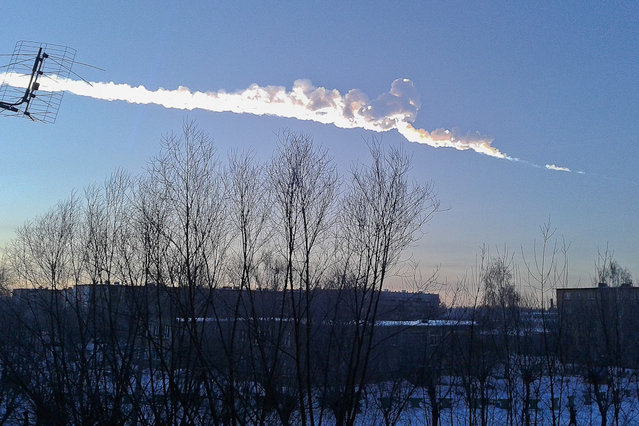
Loading...
Done


People look on as water from the rising Mississippi River is released through the Bonnet Carre Spillway while washing out a road May 9, 2011 in Norco, Louisiana. The Army Corps of Engineers began redirecting part of the Mississippi River through the spillway today to lower river levels and reduce pressure on levees in order to avoid a catastrophic failure. The water will flow nearly 6 miles north before emptying into Lake Pontchartrain as the Mississippi rises close to the highest level ever upriver in Memphis. (Photo by Mario Tama/Getty Images)
Details
11 May 2011 10:11:00


“The Toyota Winglet is a self-balancing two-wheeled scooter similar in function and form to the Segway PT and the Honda U3-X. It is capable of cruising at 3.7 miles per hour. Unveiled August 1, 2008, it is not known when or if the Winglet will be offered for consumer sale”. – Wikipedia

Photo: A Toyota Motor employee displays a proyotype model of personal transport assistance robot “Winglet” during the 11th Eco-Products 2009 – Eco Style Fair at Tokyo Big Sight on December 10, 2009 in Tokyo, Japan. (Photo by Koichi Kamoshida/Getty Images)
Details
30 May 2011 08:14:00
A car rolls south along the Dalton Highway near Coldfoot, Alaska, USA, 03 September 2017. (Photo by Jim Lo Scalzo/EPA)

A car rolls south along the Dalton Highway near Coldfoot, Alaska, USA, 03 September 2017. Stretching 414 miles (666 kilometers) north from central Alaska to Prudhoe Bay, the Dalton Highway is one of America's northernmost roads and arguably its most remote. (Photo by Jim Lo Scalzo/EPA)
Details
09 Oct 2017 08:01:00
Deadwood is pictured in the onetime spa and resort town Epecuen, November 5, 2015. (Photo by Enrique Marcarian/Reuters)

Deadwood is pictured in the onetime spa and resort town Epecuen, November 5, 2015. Over the past few years the town of Epecuen, located 550 km (341 miles) southwest of Buenos Aires, has been attracting tourists with its eerie apocalyptic atmosphere after a flood submerged it in salt water for more than two decades. Photo by Enrique Marcarian/Reuters)
Details
12 Nov 2015 08:05:00
An employe of Russian Space Training Center hangs out to dry space suits of Russian cosmonaut Anatoly Ivanishin, NASA's U.S. flight engineer Kathleen Rubins, and Japanese space agency's flight engineer Takuya Onishi, right, after their undergoing  training near in Noginsk, 60 km (38 miles) east of Moscow, Russia, Wednesday, July 2, 2014. (Photo by Alexander Zemlianichenko/AP Photo)

An employe of Russian Space Training Center hangs out to dry space suits of Russian cosmonaut Anatoly Ivanishin, NASA's U.S. flight engineer Kathleen Rubins, and Japanese space agency's flight engineer Takuya Onishi, right, after their undergoing training near in Noginsk, 60 km (38 miles) east of Moscow, Russia, Wednesday, July 2, 2014. The training was intended to simulate the capsule landing on water. Russian cosmonaut Anatoly Ivanishin, Japanese space agency's flight engineer Takuya Onishi, and NASA's U.S. flight engineer Kathleen Rubins are being trained for a future mission to the International Space Station. (Photo by Alexander Zemlianichenko/AP Photo)
Details
05 Jul 2014 11:47:00
The main church in the town of San Damian Texoloc, Mexico stands in front of the Popocatepetl volcano as is spews ash and vapor early Tuesday, July 9, 2013. Last Saturday, Mexico's National Center for Disaster Prevention raised the volcano alert from Stage 2 Yellow to Stage 3 Yellow, the final step before a Red alert, when possible evacuations could be ordered after the Popocatepetl volcano spit out a cloud of ash and vapor 2 miles (3 kilometers) high over several days of eruptions. (Photo by J. Guadalupe Perez/AP Photo)

The main church in the town of San Damian Texoloc, Mexico stands in front of the Popocatepetl volcano as is spews ash and vapor early Tuesday, July 9, 2013. Last Saturday, Mexico's National Center for Disaster Prevention raised the volcano alert from Stage 2 Yellow to Stage 3 Yellow, the final step before a Red alert, when possible evacuations could be ordered after the Popocatepetl volcano spit out a cloud of ash and vapor 2 miles (3 kilometers) high over several days of eruptions. (Photo by J. Guadalupe Perez/AP Photo)
Details
10 Jul 2013 08:45:00
Young Lebanese women wearing protective masks and gloves against the coronavirus pandemic, stand on August 5, 2020 amid the rubble in Beirut's Gimmayzeh commercial district which was heavily damaged by the previous day's powerful explosion that tore through Lebanon's capital, resulting from the ignition of a huge depot of ammonium nitrate at the city's main port. Rescuers searched for survivors in Beirut after a cataclysmic explosion at the port sowed devastation across entire neighbourhoods, killing more than 100 people, wounding thousands and plunging Lebanon deeper into crisis. The blast, which appeared to have been caused by a fire igniting 2,750 tonnes of ammonium nitrate left unsecured in a warehouse, was felt as far away as Cyprus, some 150 miles (240 kilometres) to the northwest. (Photo by AFP Photo/Stringer)

Young Lebanese women wearing protective masks and gloves against the coronavirus pandemic, stand on August 5, 2020 amid the rubble in Beirut's Gimmayzeh commercial district which was heavily damaged by the previous day's powerful explosion that tore through Lebanon's capital, resulting from the ignition of a huge depot of ammonium nitrate at the city's main port. Rescuers searched for survivors in Beirut after a cataclysmic explosion at the port sowed devastation across entire neighbourhoods, killing more than 100 people, wounding thousands and plunging Lebanon deeper into crisis. The blast, which appeared to have been caused by a fire igniting 2,750 tonnes of ammonium nitrate left unsecured in a warehouse, was felt as far away as Cyprus, some 150 miles (240 kilometres) to the northwest. (Photo by AFP Photo/Stringer)
Details
10 Aug 2020 00:05:00
Glacier National Park Montana

Glacier National Park is a national park located in the U.S. state of Montana, on the Canada–United States border with the Canadian provinces of Alberta and British Columbia. The park encompasses over 1,000,000 acres (4,000 km2) and includes parts of two mountain ranges (sub-ranges of the Rocky Mountains), over 130 named lakes, more than 1,000 different species of plants and hundreds of species of animals. This vast pristine ecosystem is the centerpiece of what has been referred to as the "Crown of the Continent Ecosystem", a region of protected land encompassing 16,000 square miles (41,000 km2).
Details
29 Oct 2013 11:13:00