Loading...
Done
Corinth Canal

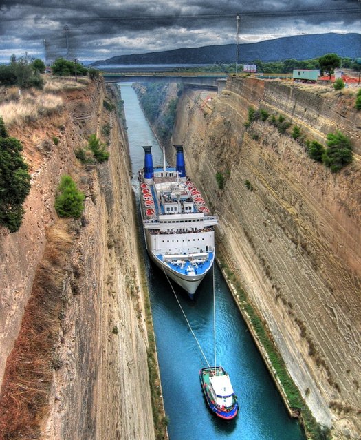
The Corinth Canal is a canal that connects the Gulf of Corinth with the Saronic Gulf in the Aegean Sea. It cuts through the narrow Isthmus of Corinth and separates the Peloponnesian peninsula from the Greek mainland, thus effectively making the former an island. The builders dug the canal through the Isthmus at sea level; no locks are employed. It is 6.4 kilometres (4.0 mi) in length and only 21.3 metres (70 ft) wide at its base, making it unpassable for most modern ships. It now has little economic importance.

Details
12 Mar 2013 12:21:00
Underground River

The Puerto Princesa Subterranean River National Park is located about 50 kilometres (30 mi) north of the city centre of Puerto Princesa, Palawan, Philippines. The river is also called Puerto Princesa Underground River. The national park is located in the Saint Paul Mountain Range on the northern coast of the island. It is bordered by St. Paul Bay to the north and the Babuyan River to the east. The City Government of Puerto Princesa has managed the National Park since 1992. The park is also known as St. Paul's Subterranean River National Park, or St. Paul Underground River. The entrance to the Subterranean River is a short hike from the town of Sabang.
Details
16 Jul 2012 11:37:00
Seven Sisters Waterfall, Norway

The Seven Sisters is the 39th tallest waterfall in Norway. The waterfall consists of seven separate streams, and the tallest of the seven has a free fall that measures 250 metres (820 ft). The waterfall is located along the Geirangerfjorden in Stranda Municipality in Møre og Romsdal county, Norway. The waterfall is located just south of the historic Knivsflå farm, across the fjord from the old Skageflå farm. The falls are about 6.5 kilometres (4.0 mi) west of the village of Geiranger. It is part of the Geiranger World Heritage Site.
Details
11 Dec 2013 10:13:00
In this Friday, March 28, 2014 photo, singers of the Moranbong Band, Jong Su Hyang, foreground, and  Pak Mi Kyong, left perform on their stage in Pyongyang, North Korea. Step aside, Sea of Blood Opera. North Korean leader Kim Jong Un's favorite guitar-slinging, miniskirt-sporting girl group, the Moranbong Band, is back. And these ladies know how to shimmy. (Photo by Jon Chol Jin/AP Photo)

In this Friday, March 28, 2014 photo, singers of the Moranbong Band, Jong Su Hyang, foreground, and Pak Mi Kyong, left perform on their stage in Pyongyang, North Korea. Step aside, Sea of Blood Opera. North Korean leader Kim Jong Un's favorite guitar-slinging, miniskirt-sporting girl group, the Moranbong Band, is back. And these ladies know how to shimmy. (Photo by Jon Chol Jin/AP Photo)
Details
27 Apr 2014 07:07:00
Shilin Stone Forest

The Stone Forest or Shilin is a notable set of limestone formations located in Shilin Yi Autonomous County, Yunnan Province, People's Republic of China, near Shilin approximately 120 km (75 mi) from the provincial capital Kunming. The tall rocks seem to emanate from the ground in the manner of stalagmites, with many looking like petrified trees thereby creating the illusion of a forest made of stone. Since 2007, two parts of the site, the Naigu Stone Forest (乃古石林) and Suogeyi Village (所各邑村), have been UNESCO World Heritage Sites as part of the South China Karst.
Details
27 Sep 2013 10:03:00
Lake Assal Crater Lake In The Central Djibouti

Lake Assal is a crater lake in central-western Djibouti. It is located at the western end of Gulf of Tadjoura in the Tadjoura Region, touching Dikhil Region, at the top of the Great Rift Valley, some 120 km (75 mi) west of Djibouti city. Lake Assal is a saline lake which lies 155 m (509 ft) below sea level in the Afar Triangle, making it the lowest point on land in Africa and the third-lowest land depression on Earth after the Dead Sea and Sea of Galilee.
Details
15 Jul 2015 10:19:00
Americans Try To Place European Countries On A Map Part 1

How sure are you of your geographical knowledge? Buzzfeed recently put Americans’ geographical knowledge to the test with a survey in which participants had to write in countries’ names on a blank European political map. Unfortunately, they didn’t fare too well, but some of their responses are hilarious (or hilariously mis-informed). But don’t be so quick to judge Americans – when Buzzfeed posted a similar survey testing Brits’ knowledge of the 50 United States, they also came up short. On the one hand, knowing a country’s states is different from knowing independent countries, but on the other, some U.S. states are larger than some European nations, and some U.S. states have larger economies than some European nations.
Details
02 Dec 2013 11:24:00
The Atlantic Road, Norway

The Atlantic Ocean Road or the Atlantic Road (Norwegian: Atlanterhavsveien) is a 8.3-kilometer (5.2 mi) long section of County Road 64 that runs through an archipelago in Eide and Averøy in Møre og Romsdal, Norway. It passes by Hustadvika, an unsheltered part of the Norwegian Sea, connecting the island of Averøy with the mainland and Romsdalshalvoya peninsula. It runs between the villages of Karvag on Averoy and Vevang in Eida. It is built on several small islands and skerries, which are connected by several causeways, viaducts and eight bridges – the most prominent being Storseisundet Bridge.
Details
18 Jan 2014 11:42:00