American model Emily Ratajkowski arrives at the British Vogue x Self Portrait Summer Party at The Chiltern Firehouse on July 13, 2023 in London, England. (Photo by David Fisher/Rex Features/Shutterstock)
A model parades an outfit by Australian label Micky In The Van at Melbourne Fashion Week in Melbourne on November 18, 2021. As Australian labels were paraded on the runway at Melbourne Fashion Week, protests took place outside by female warehouse workers claiming they are earning up to $10 less an hour than male counterparts. (Photo by William West/AFP Photo)
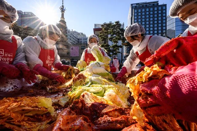
Participants prepare kimchi, a traditional Korean dish of spicy fermented cabbage and radish, during a kimchi making festival at the Jogyesa Buddhist temple in Seoul on December 2, 2021, before it is distributed among the less privileged from the local neighbourhood. (Photo by Anthony Wallace/AFP Photo)
Laos, officially the Lao People's Democratic Republic, is a landlocked country in Southeast Asia, bordered by Burma and China to the northwest, Vietnam to the east, Cambodia to the south, and Thailand to the west. Its population was estimated to be around 6.5 million in 2012. A third (33%) of the country's population lives below the international poverty line which means living on less than U.S. $1.25 per day.
Lítla Dímun is a small island between the islands of Suðuroy and Stóra Dímun in the Faroe Islands of Denmark. It is the smallest of the main 18 islands, being less than 100 hectares (250 acres) in area, and is the only uninhabited one. The island can be seen from the villages Hvalba and Sandvík.
The Intel logo is projected on the face of Intel Executive Vice President Dadi Perlmutter as he speaks during a news conference about the 3-D Tri-Gate transistors called “Ivy Bridge” on May 4, 2011 in San Francisco, California. Intel announced a technical breakthrough in the microprocessors with the world's first Tri-Gate transistors, that will increase speed and consume less energy. (Photo by Justin Sullivan/Getty Images)
A participant rests while people take part in the Mermaid Parade at Coney Island, in Brooklyn, New York, June 20, 2015. The annual parade, founded in 1983, seeks to bring mythology to life for residents, create confidence in the district and to allow artistic self-expression in public, according to the parade's website. (Photo by Eduardo Munoz/Reuters)