Loading...
Done
TSA, New Automated Target Recognition software

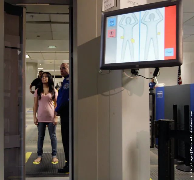
A screen shows the new Automated Target Recognition software as a TSA employee, who couldn't provide her name, waits to walk into the advanced imaging technology unit to demostrate the new software that has been installed at Miami International Airport on August 23, 2011 in Miami, Florida. The new software is designed to enhance passenger privacy by eliminating passenger-specific images and instead auto-detecting potential threat items and indicating their location on a screen which shows a generic outline of a person. (Photo by Joe Raedle/Getty Images)
Details
24 Aug 2011 09:58:00
Trementina, New Mexico. (Photo by DigitalGlobe/Caters News)

These stunning photographs may look like alien planets, but they are actually satellite images of planet Earth. Commercial satellite company DigitalGlobe recently released the images as a way of highlighting the incredible detail of their imagery – the highest-resolution commercial satellite imagery in the world. Some of the images – taken above Afghanistan, Algeria, Peru, Russia and the United States – look more like abstract works by Mondrian than segments of the globe. DigitalGlobe, based in Westminster, Colo., launched its first satellite in 1999 and currently has four in operation. Here: Trementina, New Mexico. (Photo by DigitalGlobe/Caters News)
Details
02 Oct 2015 08:01:00
Afghan men escape increasing summer temperatures by wading in the Qarga reservoir on July 9, 2010 in a suburb of Kabul, Afghanistan. (Photo by Majid Saeedi/Getty Images)

“Life in War” (FotoEvidence Press) by Iranian photographer Majid Saeedi is probably the only book about Afghanistan that doesn’t show images of war. For ten years his camera photographed daily life in the context of war. His photographs reveal the humanity of a people living through decades of war. Here: Afghan men escape increasing summer temperatures by wading in the Qarga reservoir on July 9, 2010 in a suburb of Kabul, Afghanistan. (Photo by Majid Saeedi/Getty Images)
Details
17 Oct 2014 12:07:00
Egmont National Park in New Zealand with Mt. Taranaki at its center is seen in a Landsat 8 satellite image. (Photo by Reuters/NASA/USGS)

Egmont National Park in New Zealand with Mt. Taranaki at its center is seen in a Landsat 8 satellite image taken July 3, 2014 and released by NASA November 14, 2014. The image is from the book “Sanctuary: Exploring the World's Protected Areas from Space”, published by the Institute for Global Environmental Strategies with support from NASA, which was released this week. (Photo by Reuters/NASA/USGS)
Details
16 Nov 2014 12:15:00
A close-up shot of dews of a soldier fly on August 2014, in Banten, Indonesia. Wildlife photographer takes incredible close-up images of tiny bugs. Yudy Sauw has captured close-up images of creepy crawlies – revealing their disturbing faces. The insects have an assortment bulging eyes and sharp pincers and look grotesque in the face-to-face shots. The miniature-models include a soldier fly, a red ant and a longhorn beetle. (Photo by Yudy Sauw/Barcroft Media)

A close-up shot of dews of a soldier fly on August 2014, in Banten, Indonesia. Wildlife photographer takes incredible close-up images of tiny bugs. Yudy Sauw has captured close-up images of creepy crawlies – revealing their disturbing faces. The insects have an assortment bulging eyes and sharp pincers and look grotesque in the face-to-face shots. The miniature-models include a soldier fly, a red ant and a longhorn beetle. The 33-year-old photographed the bugs at his home studio in Banten, Indonesia, placing them 2-10 centimeters away from the camera. (Photo by Yudy Sauw/Barcroft Media)
Details
22 Aug 2014 12:42:00
This image provided by NASA shows parts of Europe and Africa very easily recognizable in this night time image shot by one of the Expedition 25 crew members aboard the International Space Station flying 220 miles above Earth on Thursday Oct. 28, 2010. The view “looks” northward over Sicily and the “boot” of Italy, with the Mediterranean Sea representing most of the visible water in the view and the Adriatic Sea to the right of center. Tunisia is partially visible at left. Part of a docked Russian spacecraft and other components of the ISS are in the foreground. (Photo by AP photo/NASA)

This image provided by NASA shows parts of Europe and Africa very easily recognizable in this night time image shot by one of the Expedition 25 crew members aboard the International Space Station flying 220 miles above Earth on Thursday October 28, 2010. The view “looks” northward over Sicily and the “boot” of Italy, with the Mediterranean Sea representing most of the visible water in the view and the Adriatic Sea to the right of center. Tunisia is partially visible at left. Part of a docked Russian spacecraft and other components of the ISS are in the foreground. (Photo by AP Photo/NASA)
Details
11 May 2013 12:29:00


Look at the image for long enough and you can make the train change direction simply by thinking about it. Freaky.
Details
21 May 2013 10:55:00
In this handout image supplied by Qatar 2022  The Al-Rayyan stadium  is pictured in this artists impression as Qatar 2022 World Cup bid unveils it's stadiums on September 16, 2010 in Doha, Qatar. It has been designed to include a “media facade” that includes a membrane that acts as a screen for projections; news, commercials, sports updates and current tournament information and matches. (Photo by Qatar 2022 via Getty Images)

In this handout image supplied by Qatar 2022 The Al-Rayyan stadium is pictured in this artists impression as Qatar 2022 World Cup bid unveils it's stadiums on September 16, 2010 in Doha, Qatar. It has been designed to include a “media facade” that includes a membrane that acts as a screen for projections; news, commercials, sports updates and current tournament information and matches. (Photo by Qatar 2022 via Getty Images)
Details
13 Jul 2014 10:29:00