Loading...
Done
The possible surface of TRAPPIST-1f, one of seven newly discovered planets in the TRAPPIST-1 system that scientists using the Spitzer Space Telescope and ground based telescopes have discovered. (Photo by Reuters/NASA/JPL-Caltech)

The possible surface of TRAPPIST-1f, one of seven newly discovered planets in the TRAPPIST-1 system that scientists using the Spitzer Space Telescope and ground based telescopes have discovered. (Photo by Reuters/NASA/JPL-Caltech)
Details
07 Mar 2017 00:02:00
A wide-angle view shows the ascent of the shuttle Challenger on January 28, 1986. In the seconds after ignition, the rocket engines' hot blast began the process of destruction. (Photo by NASA)

A wide-angle view shows the ascent of the shuttle Challenger on January 28, 1986. In the seconds after ignition, the rocket engines' hot blast began the process of destruction. (Photo by NASA)
Details
28 Jan 2016 12:28:00
Mars Panorama (Photo by NASA/JPL-Caltech/MSSS/Andrew Bodrov)

360Cities PRO member Andrew Bodrov has just published another stunning panorama stitched from images taken by the Curiosity Rover on Mars. Photo: “Mars Panorama – Curiosity Rover: Martian Solar Day 177” (Photo by NASA/JPL-Caltech/MSSS/Andrew Bodrov)
Details
16 Feb 2013 09:58:00
NASA’s “Global Selfie” Earth mosaic contains more than 36,000 individual photographs from the more than 50,000 images posted around the world. (Photo by NASA)

On Earth Day this year, NASA asked people all around the world a question: “Where are you on Earth Right Now?” To answer this question people were asked to post their selfie on social media. The goal was to use each picture as a pixel in the creation of a “Global Selfie” – a mosaic image that would look like Earth appeared from the space. The 3.2 gigapixel “Global Selfie”, was made the with 36,422 individual images.
Details
25 May 2014 08:37:00
Upper Atmosphere Research Satellite (UARS)

In this artist illustration handout from the National Aeronautics and Space Administration (NASA), the Upper Atmosphere Research Satellite (UARS) is seen. According to NASA, the 12,500 pound satellite will fall from orbit into earth's atmosphere anytime between September 22 through 24. It is estimated that the space craft will break up into about 100 pieces, with an estimated 26 of which could hit the earth over a possible 500 mile debris field. (Illustration by NASA via Getty Images)
Details
21 Sep 2011 10:49:00
The second and final qualification motor (QM-2) test for the Space Launch System's booster, June 28, 2016, at Orbital ATK Propulsion Systems test facilities in Promontory, Utah. (Photo by Bill Ingalls/NASA)

The second and final qualification motor (QM-2) test for the Space Launch System's booster, June 28, 2016, at Orbital ATK Propulsion Systems test facilities in Promontory, Utah. During the Space Launch System flight the boosters will provide more than 75 percent of the thrust needed to escape the gravitational pull of the Earth, the first step on NASA's Journey to Mars. (Photo by Bill Ingalls/NASA)
Details
29 Jun 2016 11:32:00
The spinning vortex of Saturn's north polar storm resembles a deep red rose of giant proportions surrounded by green foliage in this false-color image from NASA's Cassini spacecraft. (Photo by NASA/JPL-Caltech/SSI)

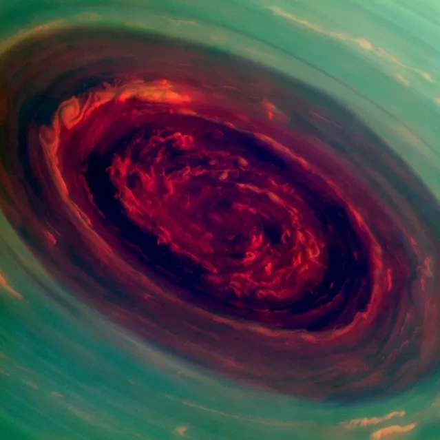
NASA's Cassini spacecraft has provided scientists the first close-up, visible-light views of a behemoth hurricane swirling around Saturn's north pole. In high-resolution pictures and video, scientists see the hurricane's eye is about 1,250 miles (2,000 kilometers) wide, 20 times larger than the average hurricane eye on Earth. Thin, bright clouds at the outer edge of the hurricane are traveling 330 mph(150 meters per second). The hurricane swirls inside a large, mysterious, six-sided weather pattern known as the hexagon. Photo: The spinning vortex of Saturn's north polar storm resembles a deep red rose of giant proportions surrounded by green foliage in this false-color image from NASA's Cassini spacecraft. (Photo by NASA/JPL-Caltech/SSI)
Details
31 May 2015 09:11:00
This image provided by NASA shows parts of Europe and Africa very easily recognizable in this night time image shot by one of the Expedition 25 crew members aboard the International Space Station flying 220 miles above Earth on Thursday Oct. 28, 2010. The view “looks” northward over Sicily and the “boot” of Italy, with the Mediterranean Sea representing most of the visible water in the view and the Adriatic Sea to the right of center. Tunisia is partially visible at left. Part of a docked Russian spacecraft and other components of the ISS are in the foreground. (Photo by AP photo/NASA)

This image provided by NASA shows parts of Europe and Africa very easily recognizable in this night time image shot by one of the Expedition 25 crew members aboard the International Space Station flying 220 miles above Earth on Thursday October 28, 2010. The view “looks” northward over Sicily and the “boot” of Italy, with the Mediterranean Sea representing most of the visible water in the view and the Adriatic Sea to the right of center. Tunisia is partially visible at left. Part of a docked Russian spacecraft and other components of the ISS are in the foreground. (Photo by AP Photo/NASA)
Details
11 May 2013 12:29:00