Loading...
Done
The Cygnus Wall is in the southern  area of NGC7000 also known as the North America Nebula. It is approximately 1800 light years from Earth, and is in the constellation Cygnus. The Wall is an energized shock front and contains the most concentrated star formations in the nebula. The size of the North America Nebula is about 4 full moons. (Bill Snyder)

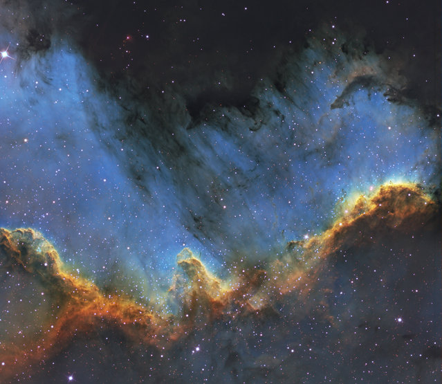
Amateur astronomer Bill Snyder has been involved with astrophotography since 2007. Photo: The Cygnus Wall is in the southern area of NGC7000 also known as the North America Nebula. It is approximately 1800 light years from Earth, and is in the constellation Cygnus. The Wall is an energized shock front and contains the most concentrated star formations in the nebula. The size of the North America Nebula is about 4 full moons. (Photo and caption by Bill Snyder)
Details
30 Oct 2013 09:15:00
Cocoa pods are seen on the ground at a farm in Ile-Oluji village in Ondo state, southwest Nigeria March 29, 2016. (Photo by Akintunde Akinleye/Reuters)

Cocoa pods are seen on the ground at a farm in Ile-Oluji village in Ondo state, southwest Nigeria March 29, 2016. (Photo by Akintunde Akinleye/Reuters)
Details
11 Apr 2016 11:02:00
Taylor Swift performs “All Too Well” at the 56th annual Grammy Awards at Staples Center. (Photo by Matt Sayles/Invision)

Taylor Swift performs “All Too Well” at the 56th annual Grammy Awards at Staples Center. (Photo by Matt Sayles/Invision)
Details
27 Jan 2014 09:55:00
From Britain to China to Mali, new maps showing travel times to the nearest urban centre reveal huge differences between countries. Using Open Street Map and Google, a University of Oxford team have created a visual breakdown that suggests major inequalities when it comes to commuting. Here: China. The dataset used for China was unique as it relied solely on Open Street Map, due to restrictions on accessing Google data. The population is densely concentrated in the east and accessibility is increased, whereas rural provinces in the west remain remote. (Photo by Daniel Weiss/Jennifer Rozier/Malaria Atlas Project/University of Oxford )

From Britain to China to Mali, new maps showing travel times to the nearest urban centre reveal huge differences between countries. Using Open Street Map and Google, a University of Oxford team have created a visual breakdown that suggests major inequalities when it comes to commuting. Here: China. The dataset used for China was unique as it relied solely on Open Street Map, due to restrictions on accessing Google data. The population is densely concentrated in the east and accessibility is increased, whereas rural provinces in the west remain remote. (Photo by Daniel Weiss/Jennifer Rozier/Malaria Atlas Project/University of Oxford)
Details
12 Jan 2018 06:43:00
The tempestuous stellar nursery called the Carina Nebula, located 7,500 light-years away from Earth in the southern constellation Carina. (Photo by Reuters/NASA)

The tempestuous stellar nursery called the Carina Nebula, located 7,500 light-years away from Earth in the southern constellation Carina. (Photo by Reuters/NASA)
Details
22 Oct 2014 13:34:00
An Indian man, Kalpesh Modi, performs stunts with his motorcycle during the rehearsal for the forthcoming Lord Jagannath Rath Yatra, an annual Hindi festival, in Ahmedabad on June 23, 2019. The 142nd Lord Jagannath Rath Yatra festival in Ahmedabad is scheduled for July 4. (Photo by Sam Panthaky/AFP Photo)

An Indian man, Kalpesh Modi, performs stunts with his motorcycle during the rehearsal for the forthcoming Lord Jagannath Rath Yatra, an annual Hindi festival, in Ahmedabad on June 23, 2019. The 142nd Lord Jagannath Rath Yatra festival in Ahmedabad is scheduled for July 4. (Photo by Sam Panthaky/AFP Photo)
Details
25 Jun 2019 00:05:00
Tank crew standing in front of M-4 tank, Ft. Knox, Kentucky, June, 1942

Tank crew standing in front of M-4 tank, Ft. Knox, Kentucky, June, 1942. (Alfred Palmer/OWI/LOC)
Details
04 May 2012 12:12:00
Pontoons, which were previously used as a floating jetty, are seen on the cracked ground of the Atibainha dam, part of the Cantareira reservoir, during a drought in Nazare Paulista, Sao Paulo state February 12, 2015. (Photo by Paulo Whitaker/Reuters)

Pontoons, which were previously used as a floating jetty, are seen on the cracked ground of the Atibainha dam, part of the Cantareira reservoir, during a drought in Nazare Paulista, Sao Paulo state February 12, 2015. Brazil's worst drought in 80 years has left the Cantareira system, that provides greater Sao Paulo with most of its water, with the lowest water level on record. Brazil's economy is already expected to post zero growth this year. Worse yet, since Brazil depends on hydroelectric dams for about three quarters of its electricity, power shortages are also possible due to the drought, federal officials have said. (Photo by Paulo Whitaker/Reuters)
Details
15 Feb 2015 14:19:00