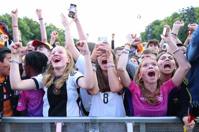
Loading...
Done


Over 60 minutes of relaxing, piano music to sleep and study!

Details
12 Jun 2015 08:12:00


2 Hours Music For Meditation and Relaxation Part 3.

Details
22 Jun 2015 15:12:00
Portraits Of Kiev’s Maidan Protesters

This man patrols the main front beside the access point to Lobanovskyi Dynamo Stadium, an area where the barricades are weak. For months now, he has slept very little. He is a carpenter.
Details
04 Mar 2014 13:41:00


Canadian artist and mother Ruth Oosterman started collaborating with her 2-year-old daughter Eve earlier this year. Ruth takes Eve’s doodles and adds watercolors to them, turning the collaborative works of art into beautiful paintings.
Details
12 Sep 2014 15:53:00


This Strange Russian Cartoon Shows Mario's Nasty Side and bogatyr or vityaz is a stock character in medieval East Slavic legends (byliny), akin to a Western European knight-errant.
Details
04 Apr 2014 23:59:00

The most intrepid mountaineers haven't seen Mt. Everest quite like this. To showcase the majestic mountain, David Breashears of GlacierWorks has created a massive, zoomable image called a "gigapan," consisting of over one billion pixels
Details
26 Dec 2012 13:38:00


Can a hamster drive a 15-tonne truck? Watch cute little Charlie steer a brand new Volvo FMX in a rough quarry. Will he make it to the top? Please like, share and comment! This is a daring test of the latest steering system. One that's so easy to handle you can steer a heavy truck with your fingertips.
Details
13 Sep 2013 10:45:00
From Britain to China to Mali, new maps showing travel times to the nearest urban centre reveal huge differences between countries. Using Open Street Map and Google, a University of Oxford team have created a visual breakdown that suggests major inequalities when it comes to commuting. Here: China. The dataset used for China was unique as it relied solely on Open Street Map, due to restrictions on accessing Google data. The population is densely concentrated in the east and accessibility is increased, whereas rural provinces in the west remain remote. (Photo by Daniel Weiss/Jennifer Rozier/Malaria Atlas Project/University of Oxford )

From Britain to China to Mali, new maps showing travel times to the nearest urban centre reveal huge differences between countries. Using Open Street Map and Google, a University of Oxford team have created a visual breakdown that suggests major inequalities when it comes to commuting. Here: China. The dataset used for China was unique as it relied solely on Open Street Map, due to restrictions on accessing Google data. The population is densely concentrated in the east and accessibility is increased, whereas rural provinces in the west remain remote. (Photo by Daniel Weiss/Jennifer Rozier/Malaria Atlas Project/University of Oxford)
Details
12 Jan 2018 06:43:00