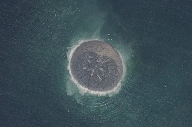
Loading...
Done
Micro or Macro? It's micro: this is an electron microscope image of the wing of a Green Darner dragonfly. (Photo by P. Kelly)

Macro or Micro? Scientists’ pictures baffle our sense of scale. It began when Stephen Young, a geography professor at Salem State University in Massachusetts, tricked his biologist colleague Paul Kelly into thinking a satellite image was one of his electron microscope scans. Can you guess whether they are close-up or very far away? (Photo by Paul Kelly)
Details
21 Apr 2014 10:24:00
Viewing The Earth From Space

Despite any political differences between the United States and Russia, the space agencies of the two countries continue their cooperative work in Earth's orbit, aboard the International Space Station. Apart from the research being done in microgravity, ISS crew members continue to send back amazing images of our home world, photographed from low Earth orbit. Gathered here are recent images of Earth from aboard the ISS, and from a handful of other NASA satellites.
Details
01 Jun 2014 12:36:00
In this 2017 photo provided by Simon Pierce, Jonathan Green checks on a fin-mounted satellite tag on a whale shark in the Galapagos Islands area of Ecuador.  Despite typically being bigger than a double-decker bus, the elusive whale shark has only tiny, almost useless teeth. It's also one of the least understood animals in the ocean. (Photo by Simonjpierce.com via AP Photo)

In this 2017 photo provided by Simon Pierce, Jonathan Green checks on a fin-mounted satellite tag on a whale shark in the Galapagos Islands area of Ecuador. Despite typically being bigger than a double-decker bus, the elusive whale shark has only tiny, almost useless teeth. It's also one of the least understood animals in the ocean. (Photo by Simonjpierce.com via AP Photo)
Details
02 Mar 2018 00:03:00
A United Launch Alliance Delta IV heavy rocket carrying classified spy satellite cargo for the U.S. National Reconnaissance Office lifts off from Space Launch Complex 37B at the Cape Canaveral Space Force Station, Tuesday, April 9, 2024, in Cape Canaveral, Fla. This is the final flight of a Delta IV heavy rocket. (Photo by John Raoux/AP Photo)

A United Launch Alliance Delta IV heavy rocket carrying classified spy satellite cargo for the U.S. National Reconnaissance Office lifts off from Space Launch Complex 37B at the Cape Canaveral Space Force Station, Tuesday, April 9, 2024, in Cape Canaveral, Fla. This is the final flight of a Delta IV heavy rocket. (Photo by John Raoux/AP Photo)
Details
21 Apr 2024 02:50:00
Batmobile Replica Spotted in Sweden

A Swedish guy built it from a 1973 Lincoln Continental. It took him over $1 million USD and 3.5 years to complete, or some 20.000 hours of work.
It features a lot of gadgets like satellite navigation, voice recognition, reversing cameras, a DVD player, a plasma TV...
Details
21 Dec 2012 13:27:00
Plus Fours Routefinder - Worlds First Navigation System

Invented in 1920′s this could be world’s first navigation system. No satellites or digital screens were used in the making of this portable navigation system. Called Plus Fours Routefinder, this little invention was designed to be worn on your wrist, and the “maps” were printed on little wooden rollers which you would turn manually as you drove along.
Details
19 Mar 2014 15:14:00


“NASA's Pathfinder, Pathfinder Plus, Centurion and Helios Prototype were an evolutionary series of solar- and fuel-cell-system-powered unmanned aerial vehicles. AeroVironment, Inc. developed the vehicles under NASA's Environmental Research Aircraft and Sensor Technology (ERAST) program. They were built to develop the technologies that would allow long-term, high-altitude aircraft to serve as “atmospheric satellites”, to perform atmospheric research tasks as well as serve as communications platforms”. – Wikipedia

Photo: The solar-electric Helios Prototype flying wing is flies over the Hawaiian islands of Niihau and Lehua during the first solar-powered test flight July 14, 2001 from the U.S. Navy's Pacific Missile Range Facility on Kauai, HI. The 18-hour flight was a functional checkout of the aircraft's systems and performance in preparation for an attempt to reach sustained flight at 100,000 feet altitude later in the summer. (Photo Courtesy of NASA/Getty Images)
Details
14 Jul 2011 09:24:00
A relative of a Chinese passenger aboard the Malaysia Airlines MH370, covers his face after being told the latest update in Beijing, China, Monday, March 24, 2014. (Photo by Ng Han Guan/AP Photo)

A relative of a Chinese passenger aboard the Malaysia Airlines MH370, covers his face after being told the latest update in Beijing, China, Monday, March 24, 2014. A new analysis of satellite data indicates the missing Malaysia Airlines plane crashed into a remote corner of the Indian Ocean, Malaysian Prime Minister Najib Razak said Monday. The news is a major breakthrough in the unprecedented two-week struggle to find out what happened to Flight 370, which disappeared shortly after takeoff from Kuala Lumpur to Beijing with 239 passengers and crew aboard on March 8. (Photo by Ng Han Guan/AP Photo)
Details
25 Mar 2014 08:26:00