Loading...
Done
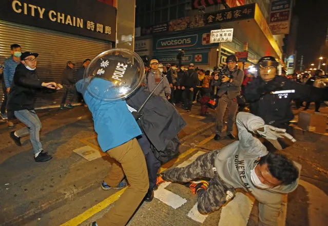
Rioters scuffle with police on a street in Mongkok district of Hong Kong, Tuesday, February 9, 2016. (Photo by Kin Cheung/AP Photo)

Rioters scuffle with police on a street in Mongkok district of Hong Kong, Tuesday, February 9, 2016. Rioters clashed with police overnight and into the early hours of Tuesday in a crowded area of Kowloon. The unrest started when local authorities tried to prevent street food sellers from operating on Monday night. Activists who are dissatisfied with Hong Kong's administration took part in the clashes, local media reports said. (Photo by Kin Cheung/AP Photo)
Details
09 Feb 2016 13:22:00
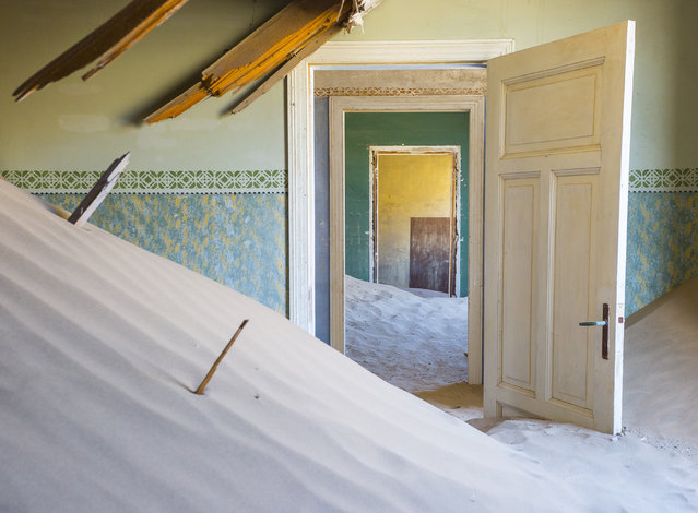
Kolmankop, an abandoned mining town in Namibia. (Photo by David Ogden/Caters News)

These sand-swept images show the ghostly remains of what was once a mineral-rich mining community. In its heyday, the town of Kolmanskop, Namibia, was home to about 700 families. Now all that remains are empty homes filled with sand, while cast-off items such as bathtubs are scattered about the surrounding area. Over time, the sand of the stunning dunes that encircle the town of Kolmanskop has been blown towards the abandoned residences, coating everything from streets to the interiors of houses and workshops. Here: Kolmankop, an abandoned mining town in Namibia. (Photo by David Ogden/Caters News)
Details
13 Mar 2016 09:31:00
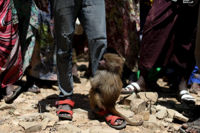
A baboon clings to the leg of an internally displaced boy at a camp on the outskirts of the town of Qol Ujeed, on the border with Ethiopia, Somaliland April 17, 2016. (Photo by Siegfried Modola/Reuters)

A baboon clings to the leg of an internally displaced boy at a camp on the outskirts of the town of Qol Ujeed, on the border with Ethiopia, Somaliland April 17, 2016. Across the Horn of Africa, millions have been hit by the severe El Nino-related drought. In Somaliland and its neighbouring, also semi-autonomous, Puntland region, 1.7 million people are in need of aid, according to the United Nations. In Somaliland itself, the most affected areas include the northwest Awdal region bordering Ethiopia. (Photo by Siegfried Modola/Reuters)
Details
29 Apr 2016 11:19:00
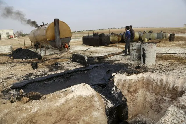
Men work at a makeshift oil refinery site in Marchmarin town, southern countryside of Idlib, Syria December 16, 2015. (Photo by Khalil Ashawi/Reuters)

Men work at a makeshift oil refinery site in Marchmarin town, southern countryside of Idlib, Syria December 16, 2015. The refinery site, owned by Yousef Ayoub, 34, has been active for 4 months. Ayoub says that he gets the crude oil from Islamic State-controlled areas in Deir al-Zor province and Iraq. The price for a barrel of crude oil varies and is controlled by the Islamic State, but it is currently at $44 dollars per barrel, he said. (Photo by Khalil Ashawi/Reuters)
Details
18 Dec 2015 08:05:00
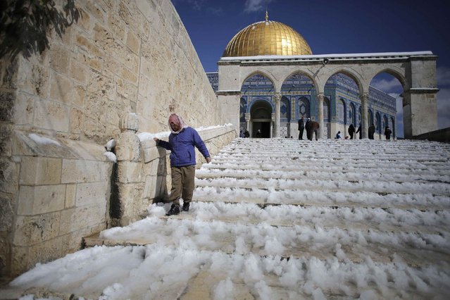
A Palestinian man walks down snow-covered stairs after Friday prayers near the Dome of the Rock on the compound known to Muslims as Noble Sanctuary and to Jews as Temple Mount, in Jerusalem's Old City February 20, 2015. (Photo by Ammar Awad/Reuters)

A Palestinian man walks down snow-covered stairs after Friday prayers near the Dome of the Rock on the compound known to Muslims as Noble Sanctuary and to Jews as Temple Mount, in Jerusalem's Old City February 20, 2015. Snow covered Jerusalem and mountainous areas of Israel early Friday morning and the education ministry closed schools for the day. (Photo by Ammar Awad/Reuters)
Details
21 Feb 2015 10:49:00
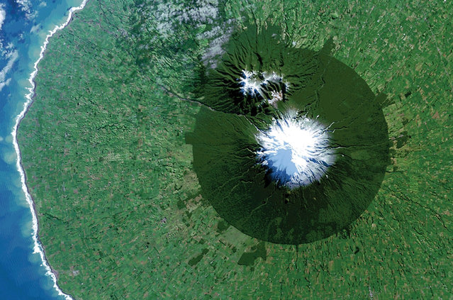
Egmont National Park in New Zealand with Mt. Taranaki at its center is seen in a Landsat 8 satellite image. (Photo by Reuters/NASA/USGS)

Egmont National Park in New Zealand with Mt. Taranaki at its center is seen in a Landsat 8 satellite image taken July 3, 2014 and released by NASA November 14, 2014. The image is from the book “Sanctuary: Exploring the World's Protected Areas from Space”, published by the Institute for Global Environmental Strategies with support from NASA, which was released this week. (Photo by Reuters/NASA/USGS)
Details
16 Nov 2014 12:15:00
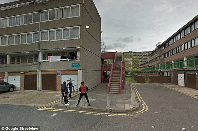
Bad Part of Town By Google Street View

Take a walk on the wild side around some of the most down right dangerous places in the world - and all without leaving your desk, courtesy of Google Street View. Since 2007, Google's amazing technology has given people the chance to visit the Eiffel Tower, peer out over San Francisco's Golden Gate Bridge or walk along a beach in the Bahamas. But as well as mapping the tourist-friendly hotspots, Google also ventured into places you really wouldn't want to find yourself. Here is a collection of some the most notorious areas captured by the infamous roaming camera cars from around the UK and the world.
Details
03 Oct 2013 11:05:00
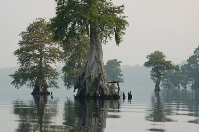
The Great Dismal Swamp

The Great Dismal Swamp is a marshy area in the Coastal Plain Region of southeastern Virginia and northeastern North Carolina, between Norfolk, Virginia, and Elizabeth City, North Carolina. It is located in parts of southern Virginia cities Chesapeake and Suffolk and northern North Carolina counties Gates, Pasquotank and Camden. It is a southern swamp, one of many along the Atlantic Ocean's coast, including the Everglades and Big Cypress Swamp in Florida, the Okefenokee Swamp in Georgia, the Congaree and Four Holes swamps of South Carolina, and some of the Carolina bays in the Carolinas and Georgia. Along the eastern edge runs the Dismal Swamp Canal, completed in 1805.
Details
09 Dec 2013 11:40:00