“Dozens of residents in a rural area of Hawaii were placed on alert as flowing lava from an erupting volcano continued to advance. Authorities on Sunday said lava flow on the Big Island of Hawaii had advanced about 250 yards since Saturday morning and was moving at the rate of about 10 to 15 yards an hour, consistent with its advancement in recent days. The flow front passed through a predominantly Buddhist cemetery, covering grave sites in the mostly rural region of Puna, and was roughly a half-mile from Pahoa Village Road, the main street of Pahoa. Darryl Oliveira, director of civil defense for Hawaii County, told reporters during a late Sunday morning teleconference that the nearest home was at least 300 yards from the flow front”. – Becky Bohrer via The Associated Press
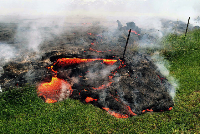
This October 25, 2014 photo provided by the U.S. Geological Survey shows lava flow advancing across the pasture between the Pahoa cemetery and Apa'a Street, engulfing a barbed wire fence, near the town of Pahoa on the Big Island of Hawaii. Dozens of residents in this rural area of Hawaii were placed on alert as flowing lava continued to advance. Authorities on Sunday, October 26, 2014 said lava had advanced about 250 yards since Saturday morning and was moving at the rate of about 10 to 15 yards an hour, consistent with its advancement in recent days. The flow front passed through a predominantly Buddhist cemetery, covering grave sites in the mostly rural region of Puna, and was roughly a half-mile from Pahoa Village Road, the main street of Pahoa. (Photo by AP Photo/U.S. Geological Survey)
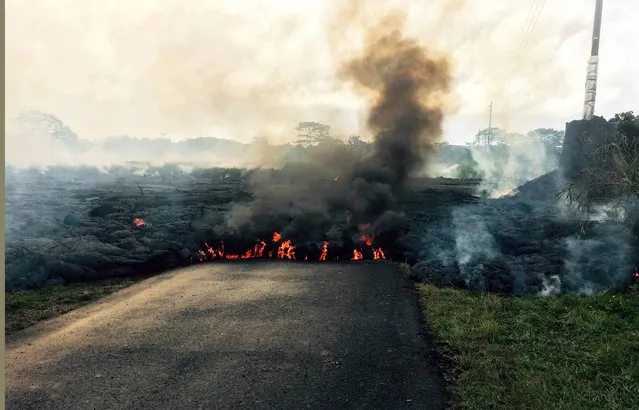
In this October 24, 2014 photo from the U.S. Geological Survey, the lava flow from Kilauea Volcano that began June 27 is seen as it crossed Apa'a Street near Cemetery Road near the town of Pahoa on the Big Island of Hawaii. Hawaii authorities on Saturday told several dozen residents near the active lava flow to prepare for a possible evacuation in the next three to five days as molten rock oozed across the country road and edged closer to homes. The USGS says the flow is currently about 160 to 230 feet (50 to 70 meters) wide and moving northeast at about 10 yards (nine meters) per hour. It's currently about six-tenths of a mile (one kilometer) from Pahoa Village Road, the town's main street. (Photo by AP Photo/U.S. Geological Survey)
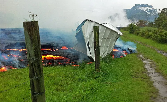
This October 25, 2014 photo provided by the U.S. Geological Survey shows a small shed being consumed by lava in a pasture between the Pahoa cemetery and Apa'a Street near the town of Pahoa on the Big Island of Hawaii. (Photo by AP Photo/U.S. Geological Survey)

This October 25, 2014 photo provided by the U.S. Geological Survey shows a Hawaii Volcano Observatory geologist standing on a partly cooled section of lava flow near the town of Pahoa on the Big Island of Hawaii. Note the thin red horizontal line of molten lava visible along the bottom third of the photo. The flow here is about one meter (three feet) thick, but slightly farther upslope where the lava has had more time to inflate the thickness was closer to two meters. (Photo by AP Photo/U.S. Geological Survey)
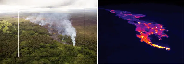
This pair of images released October 22, 2014 by the U.S. Geological Survey shows a comparison of a normal photograph of the lava flow front, left, with a thermal image of the flow that is threatening the town of Pahoa on the Big Island of Hawaii. The white box shows the approximate extent of the thermal image. The thermal image shows that active breakouts (white and yellow areas) are focused along the narrow lobe at the leading edge of the flow, but are also scattered for about 2 km (1.2 miles) behind the flow front. Authorities on Sunday, October 26, 2014 said lava had advanced about 250 yards since Saturday morning and was moving at the rate of about 10 to 15 yards an hour, consistent with its advancement in recent days. The flow front passed through a predominantly Buddhist cemetery, covering grave sites in the mostly rural region of Puna, and was roughly a half-mile from Pahoa Village Road, the main street of Pahoa. (Photo by AP Photo/U.S. Geological Survey)
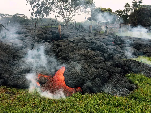
This October 26, 2014 photo provided by the U.S. Geological Survey shows the lava flow front of from an eruption that began the June 27, as the front remains active and continues to advance towards the northeast threatening the town of Pahoa on the Big Island of Hawaii. (Photo by AP Photo/U.S. Geological Survey)
27 Oct 2014 11:47:00,
post received
0 comments