Loading...
Done


“Contrails (short for “condensation trails”) or vapour trails are artificial clouds that are the visible trails of condensed water vapour made by the exhaust of aircraft engines. As the hot exhaust gases cool in the surrounding air they may precipitate a cloud of microscopic water droplets or, if the air is cold enough, tiny ice crystals”. – Wikipedia

Photo: An airplane leaves a vapor trail as it flies in front of he moon on January 17, 2007 above Hanover, Germany. (Photo by Alexander Hassenstein/Getty Images)
Details
04 Jul 2011 10:39:00
Female Chimpanzee eats carrots

Female Chimpanzee “Fifi” eats carrots as she sits in her enclosure at Taronga Zoo on her 60th birthday May 21, 2007 in Sydney, Australia. Fifi is the oldest of the Zoo's chimp population, which consists of 19 individuals. (Photo by Ian Waldie/Getty Images)
Details
07 Aug 2011 12:48:00
Graffiti At Kelburn Castle

Patrick Boyle, The Earl of Glasgow and his son David, Viscount Kelburn pose at their home Kelburn Castle on August 30, 2011 in Largs, Scotland. The Earl of Glasgow has asked Historic Scotland if the graffiti can remain as a permanent feature of the Castle. The local council allowed the mural to be painted on the wall by Brazilian artists in 2007, with a three year limit put on the graffiti pending the start of rendering work at the castle.(Photo by Jeff J Mitchell/Getty Images)
Details
31 Aug 2011 10:56:00
“Tic Tac and Tootsie (twin sisters Carrol and Shelly McKean)”. Taylor Wessing photographic portrait prize 2010. (Photo by Jeffrey Stockbridge)

“The National Portrait Gallery, London's annual photographic portrait prize was established in 2003 as the Schweppes Photographic Portrait Prize. In the years 2006 and 2007 it was referred to simply as the Photographic Portrait Prize, while from 2008 new sponsors have resulted in the name, Taylor Wessing Photographic Portait Prize”. – Wikipedia. Photo: “Tic Tac and Tootsie (twin sisters Carrol and Shelly McKean)”. Taylor Wessing photographic portrait prize 2010. (Photo by Jeffrey Stockbridge)
Details
21 Feb 2013 11:53:00
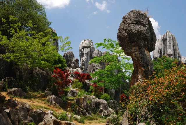
Shilin Stone Forest

The Stone Forest or Shilin is a notable set of limestone formations located in Shilin Yi Autonomous County, Yunnan Province, People's Republic of China, near Shilin approximately 120 km (75 mi) from the provincial capital Kunming. The tall rocks seem to emanate from the ground in the manner of stalagmites, with many looking like petrified trees thereby creating the illusion of a forest made of stone. Since 2007, two parts of the site, the Naigu Stone Forest (乃古石林) and Suogeyi Village (所各邑村), have been UNESCO World Heritage Sites as part of the South China Karst.
Details
27 Sep 2013 10:03:00
Bad Part of Town By Google Street View

Take a walk on the wild side around some of the most down right dangerous places in the world - and all without leaving your desk, courtesy of Google Street View. Since 2007, Google's amazing technology has given people the chance to visit the Eiffel Tower, peer out over San Francisco's Golden Gate Bridge or walk along a beach in the Bahamas. But as well as mapping the tourist-friendly hotspots, Google also ventured into places you really wouldn't want to find yourself. Here is a collection of some the most notorious areas captured by the infamous roaming camera cars from around the UK and the world.
Details
03 Oct 2013 11:05:00
Chimtarga. (Photo by Caters News/Oleg Grigoriev)

“A happy camper has shown he has the world at his feet by capturing a series of breath-taking mountain views from his tent. Russian Photographer Oleg Grigoriev, 35, travels with little more than a tent and his camera taking snaps of the mountainous terrain of central Asia and Eastern parts of Europe. The adventurous lawyer, who lives in Ukraine, started camping in remote mountainous areas in 2007 but only came up with the concept of photographing views from his tent after a memorable trip to the Fann Mountains of Tajikistan”. – Caters News
Details
14 Sep 2014 11:00:00
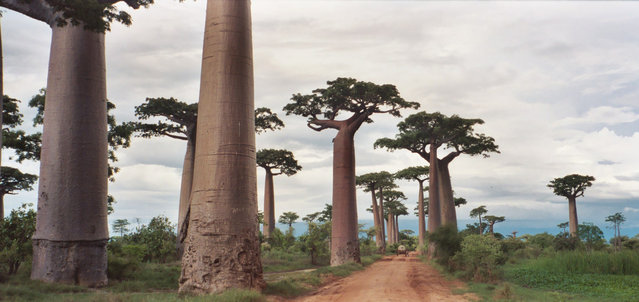
Avenue of the Baobabs

The Avenue or Alley of the Baobabs is a prominent group of baobab trees lining the dirt road between Morondava and Belon'i Tsiribihina in the Menabe region in western Madagascar. Its striking landscape draws travelers from around the world, making it one of the most visited locations in the region. It has been a center of local conservation efforts, and was granted temporary protected status in July 2007 by the Ministry of Environment, Water and Forests, the first step toward making it Madagascar's first natural monument.
Details
16 Nov 2012 10:05:00