Loading...
Done
The Atlantic Road, Norway

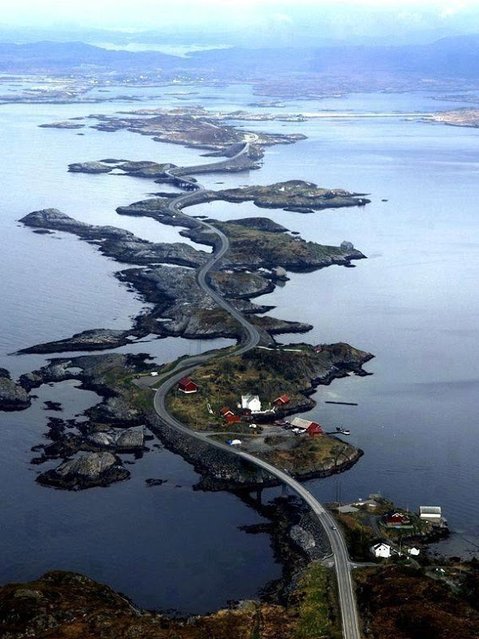
The Atlantic Ocean Road or the Atlantic Road (Norwegian: Atlanterhavsveien) is a 8.3-kilometer (5.2 mi) long section of County Road 64 that runs through an archipelago in Eide and Averøy in Møre og Romsdal, Norway. It passes by Hustadvika, an unsheltered part of the Norwegian Sea, connecting the island of Averøy with the mainland and Romsdalshalvoya peninsula. It runs between the villages of Karvag on Averoy and Vevang in Eida. It is built on several small islands and skerries, which are connected by several causeways, viaducts and eight bridges – the most prominent being Storseisundet Bridge.
Details
18 Jan 2014 11:42:00
Vivid colors and bizarre shapes come together in a false-color image that could be an illustration for a fantasy story

Vivid colors and bizarre shapes come together in a false-color image that could be an illustration for a fantasy story. This labyrinth of exotic features winds its way along the edge of Russia’s Chaunskaya Bay in northeastern Siberia, seen as a vivid blue half-circle at the bottom of the image Two major rivers, the Chaun and Palyavaam, flow into the bay, which in turn opens into the Arctic Ocean. Ribbon lakes and bogs are present throughout the area, created by depressions left by receding glaciers. (Photo by USGS/NASA)
Details
14 Apr 2012 11:02:00
“Close-up. We had a juvenile Red-Footed Booby come visit us on the sun deck. I got some closeups with my ultrawide 11-16mm Tokina”. (Photo by Carl Fredrickson)

Situated in the Pacific Ocean some 620 miles (1,000 km) from the South American continent, these 19 islands and the surrounding marine reserve have been called a unique “living museum and showcase of evolution”. Photo: “Close-up. We had a juvenile Red-Footed Booby come visit us on the sun deck. I got some closeups with my ultrawide 11-16mm Tokina”. (Photo by Carl Fredrickson)
Details
04 Sep 2013 11:49:00
A mailbox in the shape of a fire truck is seen along the highway US-1 in the Lower Keys near Marathon in Florida, July 11, 2014. (Photo by Wolfgang Rattay/Reuters)

The Florida Keys are famous for their diving, but they are less well known for another quirky attraction: the mailboxes residents use to decorate their driveways. From a fiberglass manatee in lipstick to a small white church, Reuters photographer Wolfgang Rattay documented this unusual aspect of local culture as he drove along the Ocean Highway that connects the islands. Photo: A mailbox in the shape of a fire truck is seen along the highway US-1 in the Lower Keys near Marathon in Florida, July 11, 2014. (Photo by Wolfgang Rattay/Reuters)
Details
03 Aug 2014 07:25:00
The NASA Extreme Environment Mission Operations (NEEMO) 21 mission began on July 21 as an international crew of aquanauts splashed down to the undersea Aquarius Reef Base, located 62 feet below the surface of the Atlantic Ocean in the Florida Keys National Marine Sanctuary. The NEEMO 21 crew will perform research both inside and outside the habitat during a 16-day simulated space mission. During simulated spacewalks carried out underwater, they will evaluate tools and mission operation techniques that could be used in future space missions, including journeys to Mars. (Photo by Karl Shreeves/NASA)

The NASA Extreme Environment Mission Operations (NEEMO) 21 mission began on July 21 as an international crew of aquanauts splashed down to the undersea Aquarius Reef Base, located 62 feet below the surface of the Atlantic Ocean in the Florida Keys National Marine Sanctuary. The NEEMO 21 crew will perform research both inside and outside the habitat during a 16-day simulated space mission. During simulated spacewalks carried out underwater, they will evaluate tools and mission operation techniques that could be used in future space missions, including journeys to Mars. (Photo by Karl Shreeves/NASA)
Details
31 Jul 2016 11:29:00
A couple kiss as strong waves hit the coast in Saint-Benoit, on the east of the French Indian Ocean island of La Reunion, on February 2, 2022, ahead of the passage of tropical cyclone Batsirai. La Reunion goes on red alert at 7 pm on February 2, to prepare for the likely passage of cyclone Batsirai overnight. The cyclone already left at least 7,500 homes in nearby Mauritius without power, after it brought heavy downpours and winds of around 120 kilometres per hour, knocking down trees onto electricity lines, according to the local electricity board. (Photo by Richard Bouhet/AFP Photo)

A couple kiss as strong waves hit the coast in Saint-Benoit, on the east of the French Indian Ocean island of La Reunion, on February 2, 2022, ahead of the passage of tropical cyclone Batsirai. La Reunion goes on red alert at 7 pm on February 2, to prepare for the likely passage of cyclone Batsirai overnight. The cyclone already left at least 7,500 homes in nearby Mauritius without power, after it brought heavy downpours and winds of around 120 kilometres per hour, knocking down trees onto electricity lines, according to the local electricity board. (Photo by Richard Bouhet/AFP Photo)
Details
03 Feb 2022 07:38:00
In this undated handout photo taken by mrwed54, a woman poses for a photo by a lake in the Siberian city of Novosibirsk, about 2,800 kilometers (1,750 miles) east of Moscow, Russia. Thousands of Novosibirsk residents, from scantily clad women to newlyweds have been instagramming selfies near the lake nicknamed the “Siberian Malvides” after the far-flung tropical islands in the Indian Ocean. This is in fact is a man-made dumb of coal from a nearby power station that provides for most of Novosibirsk’s energy needs. Environmentalists are warning people against coming into contact with the water. (Photo by mrwed54 via AP Photo)

In this undated handout photo taken by mrwed54, a woman poses for a photo by a lake in the Siberian city of Novosibirsk, about 2,800 kilometers (1,750 miles) east of Moscow, Russia. Thousands of Novosibirsk residents, from scantily clad women to newlyweds have been instagramming selfies near the lake nicknamed the “Siberian Malvides” after the far-flung tropical islands in the Indian Ocean. This is in fact is a man-made dumb of coal from a nearby power station that provides for most of Novosibirsk’s energy needs. Environmentalists are warning people against coming into contact with the water. (Photo by mrwed54 via AP Photo)
Details
15 Jul 2019 00:07:00
Wave Rock, Arizona

Wave Rock is a natural rock formation that is shaped like a tall breaking ocean wave. The "wave" is about 14 m (46 ft) high and around 110 m (360 ft) long. It forms the north side of a solitary hill, which is known as “Hyden Rock”. This hill, which is a granite inselberg, lies about 3 km (2 mi) east of the small town of Hyden and 296 km (184 mi) east-southeast of Perth, Western Australia. Wave Rock and Hyden Rock are part of a 160 ha (395-acre) nature reserve, Hyden Wildlife Park.
Details
12 Aug 2014 10:21:00