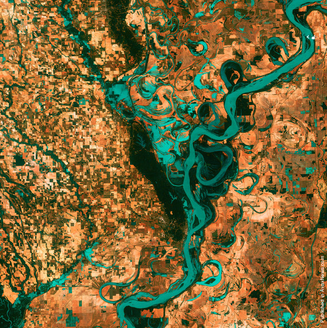
Small, blocky shapes of towns, fields and pastures surround the graceful swirls and whorls of the Mississippi River. Countless oxbow lakes and cutoffs accompany the meandering river south of Memphis, Tenn., on the border between Arkansas and Mississippi. The “mighty Mississippi” is the largest river system in North America. (Photo by USGS/NASA)
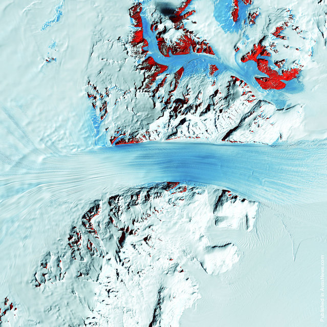
Truly a river of ice, Antarctica’s relatively fast-moving Byrd Glacier courses through the Transantarctic Mountains at a rate of half a mile (0.8 kilometers) per year. More than 180 kilometers (112 miles) long, the glacier flows down from the polar plateau (left) to the Ross Ice Shelf (right). Long, sweeping flow lines are crossed in places by much shorter lines, which are deep cracks in the ice called crevasses. In this color-coded multispectral image, the conspicuous red patches indicate areas of exposed rock. (Photo by USGS/NASA)
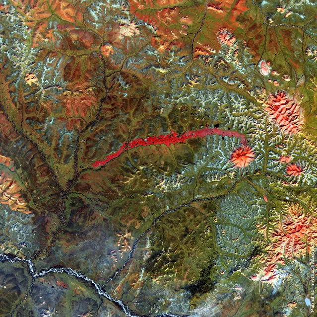
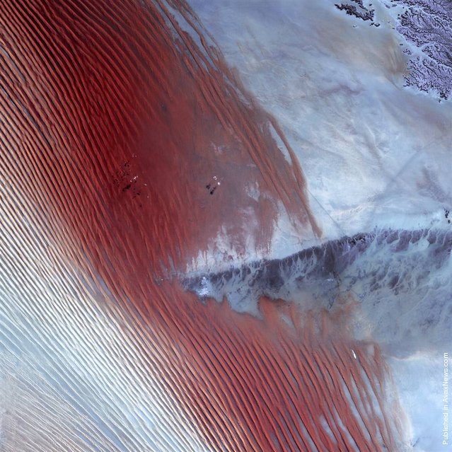
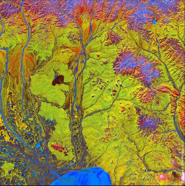
The prominent crimson streak in the center of this image represents the remains of an extensive lava and mud flow. Its source is the currently dormant Anyuyskiy Volcano in northeastern Russia, seen here as an orange circular shape at the right end of the streak. Remote and largely inaccessible, the region is a rugged collection of towering volcanic peaks, steep valleys and wild, snow-fed rivers and streams. (Photo by USGS/NASA)
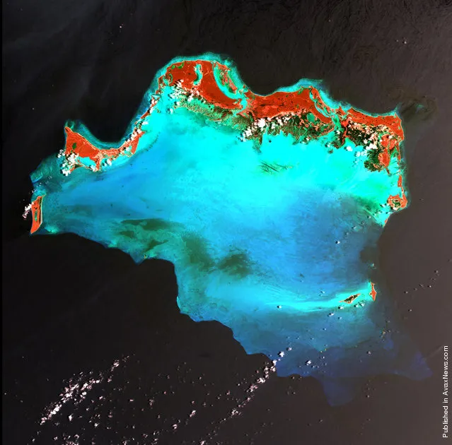
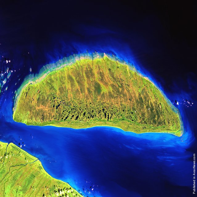
The Caicos Islands in the northern Caribbean are a popular tourist attraction, renowned for their beautiful beaches, clear waters, scuba diving and luxury resorts. The islands lie primarily along the northern perimeter of the submerged Caicos Bank, a shallow limestone platform formed of sand, algae, and coral reefs covering 2,370 square miles (6,140 square kilometers). In this color-coded image, the Caicos Bank shows up in turquoise, and vegetation shows up in red. (Photo by USGS/NASA)
White pinpricks of cloud cast ebony shadows on the Rub’ al Khali, or Empty Quarter, near the border between Saudi Arabia and Yemen. The lines of wind-sculpted sand are characteristic of immense sand deserts, or sand seas, and the Rub’ al Khali is the largest desert of this type in the world. A highland ridge is just high enough to disturb the flow of the lines. In the center of that interruption lies the Saudi town of Sharurah. (Photo by USGS/NASA)
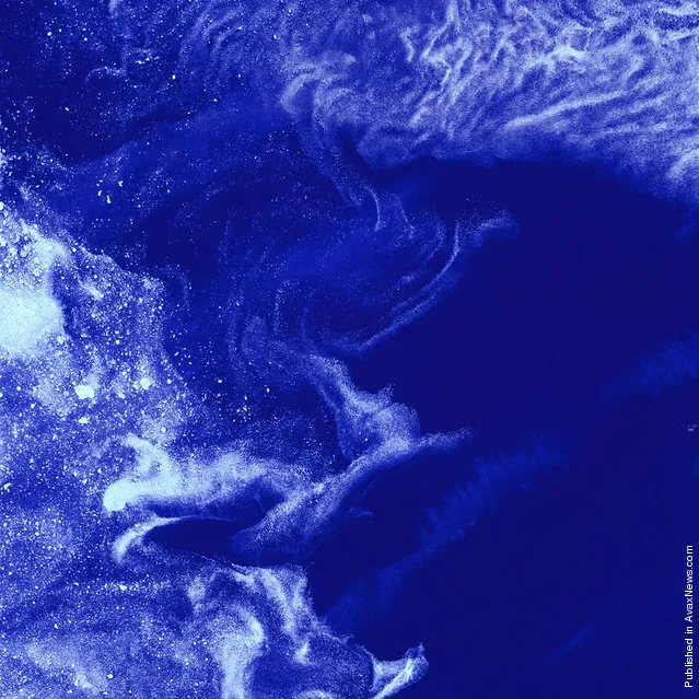
Like distant galaxies amid clouds of interstellar dust, chunks of sea ice drift through graceful swirls of grease ice in the frigid waters of Foxe Basin near Baffin Island in the Canadian Arctic. Sea ice often begins as grease ice, a soupy slick of tiny ice crystals on the ocean’s surface. As the temperature drops, grease ice thickens and coalesces into slabs of more solid ice. (Photo by USGS/NASA)
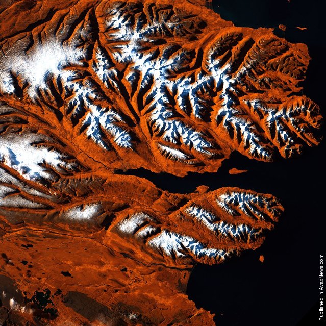
This stretch of Iceland’s northern coast resembles a tiger’s head, complete with stripes of orange, black and white. The tiger’s mouth is the great Eyjafjordur, a deep fjord that juts into the mainland between steep mountains. The name means “island fjord”, derived from the tiny, tear-shaped Hrísey Island near its mouth. The ice-free port city of Akureyri lies near the fjord’s narrow tip, and is Iceland’s second-largest population center after the capital, Reykjavik. (Photo by USGS/NASA)
During the last ice age, Akimiski Island in Canada’s James Bay lay beneath vast glaciers that pressed down with immense force. As the climate changed and the ice retreated, Akimiski began a gradual rebound. The island’s slow but steady increase in elevation is recorded along its naturally terraced edges where the coastline seems etched with bathtub rings, the result of the rising landmass and wave action at previous sea levels. (Photo by USGS/NASA)
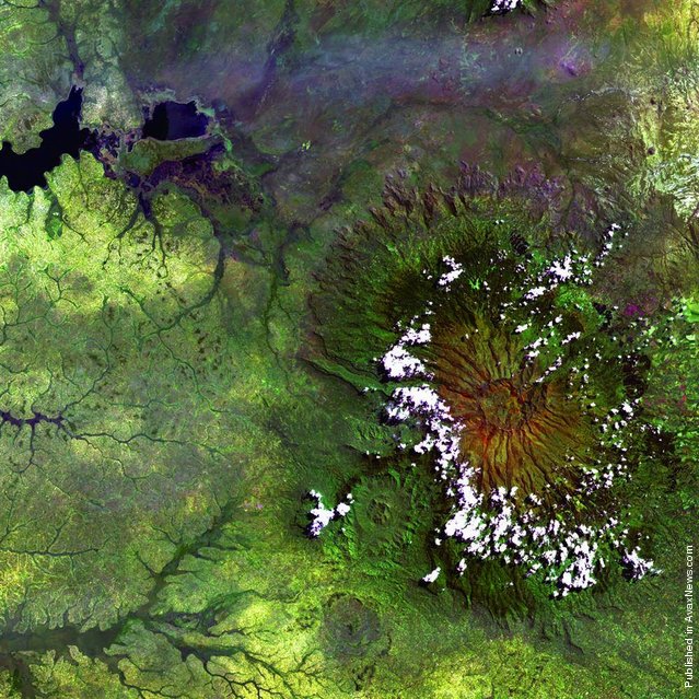
Clouds encircle the lofty rim of Africa’s Mount Elgon, a huge, long-extinct volcano on the border between Uganda and Kenya. The solitary volcano has one of the world’s largest intact calderas, a cauldronlike central depression. The caldera is about 4.5 miles (6.5 kilometers) across and formed following an eruption, when the emptied magma chamber collapsed under the weight of volcanic rock above it. (Photo by USGS/NASA)
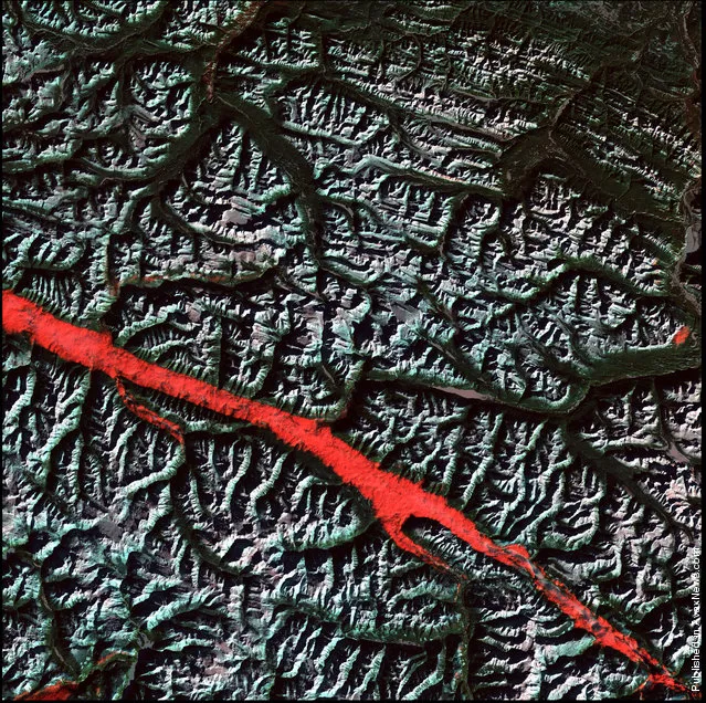
What appears to be a stroke of thick red paint is actually a remarkable interplay of light and cloud in the Canadian Rockies. Angling through the mountains is part of the Rocky Mountain Trench, a valley that extends from Montana to just south of the Yukon Territory. Low clouds filled a part of the trench near the border between the Canadian provinces of Alberta and British Columbia. The light-reflecting nature of the clouds, coupled with low sun elevation, resulted in this startling effect. (Photo by USGS/NASA)
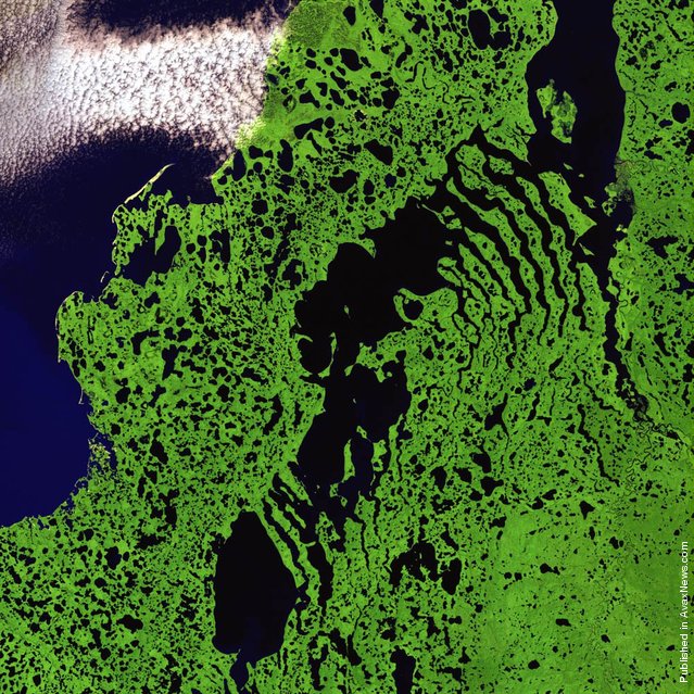
Skeletal extensions of land reach like bony fingers across a section of Liverpool Bay along the northern edge of Canada’s Northwest Territories. Only small villages are thinly scattered in this remote and inhospitable region of Arctic tundra bordering the Beaufort Sea. The relatively flat landscape is dotted with shallow lakes during the extremely brief summer season. (Photo by USGS/NASA)
Vivid colors and bizarre shapes come together in a false-color image that could be an illustration for a fantasy story. This labyrinth of exotic features winds its way along the edge of Russia’s Chaunskaya Bay in northeastern Siberia, seen as a vivid blue half-circle at the bottom of the image Two major rivers, the Chaun and Palyavaam, flow into the bay, which in turn opens into the Arctic Ocean. Ribbon lakes and bogs are present throughout the area, created by depressions left by receding glaciers. (Photo by USGS/NASA)
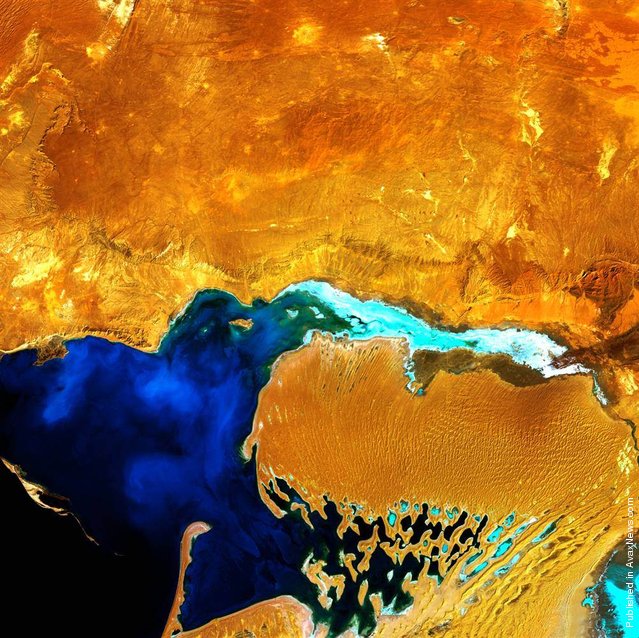
Looking like a monstrous ogre with something gooey in its mouth, the Dardzha Peninsula in western Turkmenistan lies among the shallow coastal terraces of the Caspian Sea. Strong winds create huge sand dunes near the water, some of which are partly submerged. Further inland, the dunes transition to low sand plains. (Photo by USGS/NASA)
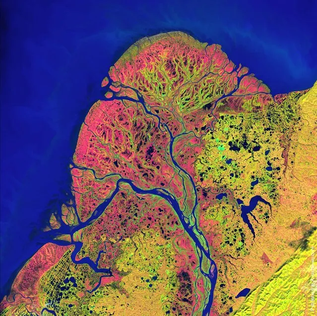
After beginning in northern British Columbia and flowing through Canada's Yukon Territory, the Yukon River crosses Alaska before emptying into the Bering Sea. Countless lakes, sloughs and ponds are scattered throughout this scene of the Yukon Delta. The river’s sinuous, branching waterways seem like blood vessels branching out to enclose an organ. It is one of the largest river deltas in the world, and is currently protected as part of the Yukon Delta National Wildlife Refuge. (Photo by USGS/NASA)
14 Apr 2012 11:02:00,
post received
0 comments