Loading...
Done
Real-Time Face Tracking And Projection Mapping By Nobumichi Asai

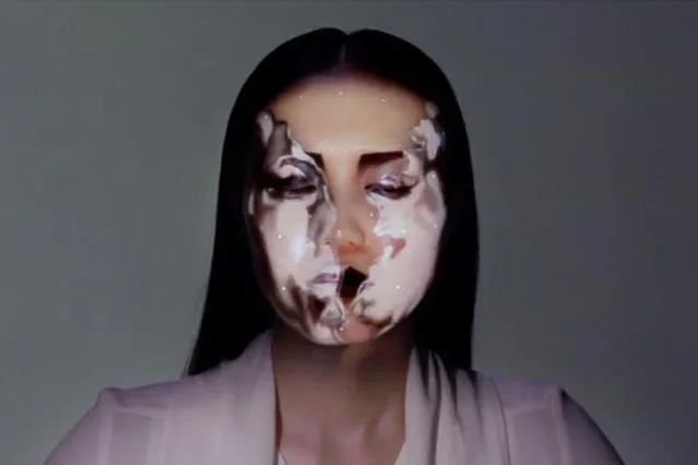
Nobumichi Asai has used projection mapping to put CGI onto cars, docks, building and more. What is his latest canvas? A real, live human face! Asai used Omote, a combination of real-time face tracking and projection mapping to transform a model's face into mesmerizing patterns. It's called “electronic makeup”, but as you will see in the (creepy-ish) video, it goes much, much beyond anything makeup can possibly do.
Details
20 Aug 2014 10:49:00
Americans Try To Place European Countries On A Map Part 2

How sure are you of your geographical knowledge? Buzzfeed recently put Americans’ geographical knowledge to the test with a survey in which participants had to write in countries’ names on a blank European political map. Unfortunately, they didn’t fare too well, but some of their responses are hilarious (or hilariously mis-informed). But don’t be so quick to judge Americans – when Buzzfeed posted a similar survey testing Brits’ knowledge of the 50 United States, they also came up short. On the one hand, knowing a country’s states is different from knowing independent countries, but on the other, some U.S. states are larger than some European nations, and some U.S. states have larger economies than some European nations.
Details
03 Dec 2013 08:45:00
Google's vice president Alan Eustace looks out of his spacesuit into the stratosphere prior to a record-breaking skydive over New Mexico, in this still image taken from video October 24, 2014, a handout courtesy of the Paragon Space Development Corporation. Eustace was lifted up 135,890 ft (41,420 metres) by an enormous balloon while wearing a specially designed pressurized space suit, the Paragon Space Development Corporation said. (Photo by Reuters/Paragon Space Development Corporation)

Google's vice president Alan Eustace looks out of his spacesuit into the stratosphere prior to a record-breaking skydive over New Mexico, in this still image taken from video October 24, 2014, a handout courtesy of the Paragon Space Development Corporation. Eustace was lifted up 135,890 ft (41,420 metres) by an enormous balloon while wearing a specially designed pressurized space suit, the Paragon Space Development Corporation said. Eustace remained in a free fall for approximately 4.5 minutes before landing safely nearly 70 miles (43.4 kms) from his launch point, setting a world record for the highest skydive and breaking the sound barrier in the process. Eustace landed safely on the ground just 15 minutes after he was lifted into the air. (Photo by Reuters/Paragon Space Development Corporation)
Details
26 Oct 2014 12:16:00
A Google balloon sails through the air with the Southern Alps mountains in the background, in Tekapo, New Zealand. (Photo by Jon Shenk/Associated Press)

“Google is launching balloons into near space to provide internet access to buildings below on the ground. About 30 of the superpressure balloons are being launched from New Zealand from where they will drift around the world on a controlled path. Attached equipment will offer 3G-like speeds to 50 testers in the country”. – BBC News. Photo: A Google balloon sails through the air with the Southern Alps mountains in the background, in Tekapo, New Zealand. (Photo by Jon Shenk/Associated Press)
Details
16 Jun 2013 10:54:00
New 3-D Map of Massive Galaxies and Distant Black Holes Offers Clues to Dark Matter and Dark Energy

“The Sloan Digital Sky Survey III (SDSS-III) has released the largest-ever three-dimensional map of massive galaxies and distant black holes, which will help astronomers explain the mysterious “dark matter” and “dark energy” that scientists know makes up 96 percent of the Universe”. – SDSS-III
Details
10 Aug 2012 09:01:00
From Britain to China to Mali, new maps showing travel times to the nearest urban centre reveal huge differences between countries. Using Open Street Map and Google, a University of Oxford team have created a visual breakdown that suggests major inequalities when it comes to commuting. Here: China. The dataset used for China was unique as it relied solely on Open Street Map, due to restrictions on accessing Google data. The population is densely concentrated in the east and accessibility is increased, whereas rural provinces in the west remain remote. (Photo by Daniel Weiss/Jennifer Rozier/Malaria Atlas Project/University of Oxford )

From Britain to China to Mali, new maps showing travel times to the nearest urban centre reveal huge differences between countries. Using Open Street Map and Google, a University of Oxford team have created a visual breakdown that suggests major inequalities when it comes to commuting. Here: China. The dataset used for China was unique as it relied solely on Open Street Map, due to restrictions on accessing Google data. The population is densely concentrated in the east and accessibility is increased, whereas rural provinces in the west remain remote. (Photo by Daniel Weiss/Jennifer Rozier/Malaria Atlas Project/University of Oxford)
Details
12 Jan 2018 06:43:00
Natural gas plant in Pittsburg, CA (detail of Power Landscape), 2013. (Photo by Jenny Odell)

Jenny Odell repurposes online imagery mostly from Google Maps, but also from YouTube, Craigslist, and other sites. In her “Satellite Collections”, for example, she incorporated aerial views of swimming pools, basketball courts, parking lots, and other recognizable structures, seen from space. Her more recent series, “Satellite Landscapes”, includes painstakingly isolated Google Maps imagery of oil refineries, wastewater treatment plants, solar farms, etc. This work is meant as a reminder of our physically determined and vulnerable existence, since we depend on many of these things for survival and maintenance of our way of life. Photo: Natural gas plant in Pittsburg, CA (detail of Power Landscape), 2013. (Photo by Jenny Odell)
Details
19 Mar 2014 07:28:00
South Korean youths play Pokemon Go on July 15, 2016 in Sokcho, South Korea. (Photo by Jean Chung/Getty Images)

South Korean youths play Pokemon Go on July 15, 2016 in Sokcho, South Korea. South Korea is not one of the initial Pokemon Go released countries, nor is the game likely to be released officially any time soon as the South Korean government does not allow Google to use its map; however, South Korean game enthusiasts are now visiting a handful of loophole areas in the north eastern side of the country near the border of North Korea to join the global frenzy of Pokemon Go. (Photo by Jean Chung/Getty Images)
Details
16 Jul 2016 08:49:00