Loading...
Done
Dive The Deadly Jacob’s Well In Texas

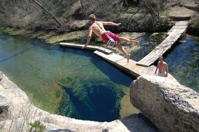
Jacob's Well is a perennial karstic spring in the Texas Hill Country flowing from the bed of Cypress Creek, located northwest of Wimberley, Texas. The twelve foot (four meter) diameter mouth of the spring serves as a popular swimming spot for the local land owners whose properties adjoin Cypress Creek. From the opening in the creek bed, Jacob's Well cave descends vertically for about thirty feet (ten meters), then continues downward at an angle through a series of silted chambers separated by narrow restrictions, finally reaching a depth of one hundred and twenty feet (forty meters). Until the modern era, the Trinity Aquifer-fed natural artesian spring gushed water from the mouth of the cave, with a measured flow in 1924 of one hundred and seventy gallons per second (six hundred and forty liters per second) discharging six feet (two meters) into the air. The spring is the greatest source of water recharging the Edwards Aquifer.
Details
03 Jan 2014 08:20:00
Pictures from Tasmania’s central plateau, shot by wilderness photographer Dan Broun, show the extraordinary damage wrought by more than a week of bushfires following lightning strikes in Australia’s southernmost state on January 13. 2016. The world heritage area was home to a range of unique alpine flora including pencil pines, king billy pines and cushion plants, some more than 1,000 years old. (Photo by Dan Broun)

Pictures from Tasmania’s central plateau, shot by wilderness photographer Dan Broun, show the extraordinary damage wrought by more than a week of bushfires following lightning strikes in Australia’s southernmost state on January 13. 2016. The world heritage area was home to a range of unique alpine flora including pencil pines, king billy pines and cushion plants, some more than 1,000 years old. Now more than 10,000ha of land has been incinerated, and ecologist say that, unlike eucalyptus trees, the ancient flora will not recover. (Photo by Dan Broun)
Details
02 Feb 2016 13:56:00


“US Airways Flight 1549 was US Airways' scheduled domestic commercial passenger flight from LaGuardia Airport in New York City to Charlotte/Douglas International Airport, Charlotte, North Carolina. On January 15, 2009, the aircraft flying this route, an Airbus A320-214, was successfully ditched in the Hudson River adjacent to midtown Manhattan six minutes after takeoff from LaGuardia Airport after being disabled by striking a flock of Canada Geese during its initial climb out. The incident became known as the «Miracle On The Hudson»”. – Wikipedia

Photo: The Airbus jet that pilot Chesley “Sully” Sullenberger landed on the Hudson River is pulled along Yorkmont Road as it makes its way to the Carolinas Aviation Museum June 10, 2011 in Charlotte, North Carolina. An official unveiling of the plane, which will be on display at the Carolinas Avaiation Museum, will take place on Saturday, June 11. (Photo by Davis Turner/Getty Images)
Details
11 Jun 2011 12:38:00
Members of the Michiana Rocketry prep a 10-foot, 450 pound porta-potty, mounted on rocket motors for launching, Saturday, December 6, 2014, from a field in Three Oaks, Mich. (Photo by Don Campbell/AP Photo/The Herald-Palladium)

Members of the Michiana Rocketry prep a 10-foot, 450 pound porta-potty, mounted on rocket motors for launching, Saturday, December 6, 2014, from a field in Three Oaks, Mich. It made an arc and almost landed on a spectator’s pickup truck, 2,000 feet away. A group of Michiana Rocketry club members planned the project for more than two years. The club is trying to increase awareness of rocketry as a hobby and prove it’s possible to turn a porta-potty into a rocket and launch it successfully. About 30 people worked on the rocket, from engineers to sales people who lined up sponsors. (Photo by Don Campbell/AP Photo/The Herald-Palladium)
Details
10 Dec 2014 11:43:00
A Ka'apor Indian warrior (L) chases a logger who tried to escape after they captured him during a jungle expedition to search for and expel loggers from the Alto Turiacu Indian territory, near the Centro do Guilherme municipality in the northeast of Maranhao state in the Amazon basin, August 7, 2014. (Photo by Lunae Parracho/Reuters)

A Ka'apor Indian warrior (L) chases a logger who tried to escape after they captured him during a jungle expedition to search for and expel loggers from the Alto Turiacu Indian territory, near the Centro do Guilherme municipality in the northeast of Maranhao state in the Amazon basin, August 7, 2014. Tired of what they say is a lack of sufficient government assistance in keeping loggers off their land, the Ka'apor Indians, who along with four other tribes are the legal inhabitants and caretakers of the territory, have sent their warriors out to expel all loggers they find and set up monitoring camps in the areas that are being illegally exploited. (Photo by Lunae Parracho/Reuters)
Details
05 Sep 2014 11:41:00
Roped up climbers leave the summit of Breithorn at 4,164 metres (13,661 feet) on the ridge marking the border with Switzerland (left) and Italy in the Alpine resort of Zermatt August 4, 2014. Switzerland will vote on November 30 on an initiative from the group Ecopop which proposes a cap on the number of immigrants. (Photo by Denis Balibouse/Reuters)

Roped up climbers leave the summit of Breithorn at 4,164 metres (13,661 feet) on the ridge marking the border with Switzerland (left) and Italy in the Alpine resort of Zermatt August 4, 2014. Switzerland will vote on November 30 on an initiative from the group Ecopop which proposes a cap on the number of immigrants. The group says it is motivated by concerns about a lack of living space exerting too much pressure on the land and natural resources, rather than by opposition to foreigners. (Photo by Denis Balibouse/Reuters)
Details
04 Nov 2014 14:29:00
Water is seen on part of the glacial ice sheet that covers about 80 percent of the country is seen on July 17, 2013 on the Glacial Ice Sheet, Greenland. (Photo by Joe Raedle/Getty Images via The Atlantic)

Water is seen on part of the glacial ice sheet that covers about 80 percent of the country is seen on July 17, 2013 on the Glacial Ice Sheet, Greenland. As the sea levels around the globe rise, researchers affilitated with the National Science Foundation and other organizations are studying the phenomena of the melting glaciers and its long-term ramifications. The warmer temperatures that have had an effect on the glaciers in Greenland also have altered the ways in which the local populace farm, fish, hunt and even travel across land. In recent years, sea level rise in places such as Miami Beach has led to increased street flooding and prompted leaders such as New York City Mayor Michael Bloomberg to propose a $19.5 billion plan to boost the citys capacity to withstand future extreme weather events by, among other things, devising mechanisms to withstand flooding. (Photo by Joe Raedle)
Details
02 Aug 2013 10:51:00
A Rohingya migrant who arrived in Indonesia by boat cries while speaking on a mobile phone with a relative in Malaysia, at a temporary shelter in Kuala Langsa in Indonesia's Aceh Province May 16, 2015. (Photo by Roni Bintang/Reuters)

A Rohingya migrant who arrived in Indonesia by boat cries while speaking on a mobile phone with a relative in Malaysia, at a temporary shelter in Kuala Langsa in Indonesia's Aceh Province May 16, 2015. Nearly 800 migrants were brought ashore in Indonesia on Friday, but other vessels crammed with them were sent back to sea despite a United Nations call to rescue thousands adrift in Southeast Asian waters with dwindling food and water. Thousands of Rohingya Muslims fleeing Myanmar and Bangladesh are stranded on boats as regional governments block them from landing. (Photo by Roni Bintang/Reuters)
Details
20 May 2015 08:53:00