Loading...
Done
Seven Sisters Waterfall, Norway

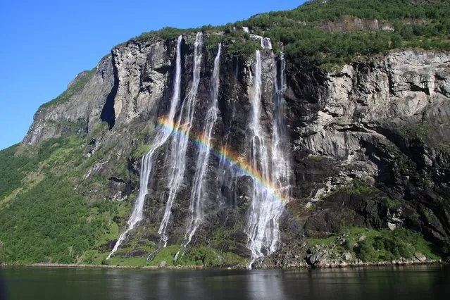
The Seven Sisters is the 39th tallest waterfall in Norway. The waterfall consists of seven separate streams, and the tallest of the seven has a free fall that measures 250 metres (820 ft). The waterfall is located along the Geirangerfjorden in Stranda Municipality in Møre og Romsdal county, Norway. The waterfall is located just south of the historic Knivsflå farm, across the fjord from the old Skageflå farm. The falls are about 6.5 kilometres (4.0 mi) west of the village of Geiranger. It is part of the Geiranger World Heritage Site.
Details
11 Dec 2013 10:13:00
Corinth Canal

The Corinth Canal is a canal that connects the Gulf of Corinth with the Saronic Gulf in the Aegean Sea. It cuts through the narrow Isthmus of Corinth and separates the Peloponnesian peninsula from the Greek mainland, thus effectively making the former an island. The builders dug the canal through the Isthmus at sea level; no locks are employed. It is 6.4 kilometres (4.0 mi) in length and only 21.3 metres (70 ft) wide at its base, making it unpassable for most modern ships. It now has little economic importance.

Details
12 Mar 2013 12:21:00
Underground River

The Puerto Princesa Subterranean River National Park is located about 50 kilometres (30 mi) north of the city centre of Puerto Princesa, Palawan, Philippines. The river is also called Puerto Princesa Underground River. The national park is located in the Saint Paul Mountain Range on the northern coast of the island. It is bordered by St. Paul Bay to the north and the Babuyan River to the east. The City Government of Puerto Princesa has managed the National Park since 1992. The park is also known as St. Paul's Subterranean River National Park, or St. Paul Underground River. The entrance to the Subterranean River is a short hike from the town of Sabang.
Details
16 Jul 2012 11:37:00
Trip to Xi'an 西安. (Photo by Grant)

“Mount Hua, or Hua Shan, or Xiyue located near the city of Huayin in Shaanxi province, about 120 kilometres (75 mi) east of Xi'an. It is one of China's Five Great Mountains, and has a long history of religious significance. Originally classified as having three peaks, in modern times the mountain is classified as five main peaks, of which the highest is the South Peak at 2,154.9 metres (7,070 ft)”. – Wikipedia

Photo: Trip to Xi'an 西安. (Photo by Grant Robinson)
Details
11 Nov 2012 11:39:00

孫語賽×蕭全 – 不僅僅是喜歡 (Official Music Video)
Details
13 Nov 2019 00:01:00
Lake Assal Crater Lake In The Central Djibouti

Lake Assal is a crater lake in central-western Djibouti. It is located at the western end of Gulf of Tadjoura in the Tadjoura Region, touching Dikhil Region, at the top of the Great Rift Valley, some 120 km (75 mi) west of Djibouti city. Lake Assal is a saline lake which lies 155 m (509 ft) below sea level in the Afar Triangle, making it the lowest point on land in Africa and the third-lowest land depression on Earth after the Dead Sea and Sea of Galilee.
Details
15 Jul 2015 10:19:00
Shilin Stone Forest

The Stone Forest or Shilin is a notable set of limestone formations located in Shilin Yi Autonomous County, Yunnan Province, People's Republic of China, near Shilin approximately 120 km (75 mi) from the provincial capital Kunming. The tall rocks seem to emanate from the ground in the manner of stalagmites, with many looking like petrified trees thereby creating the illusion of a forest made of stone. Since 2007, two parts of the site, the Naigu Stone Forest (乃古石林) and Suogeyi Village (所各邑村), have been UNESCO World Heritage Sites as part of the South China Karst.
Details
27 Sep 2013 10:03:00
Salar de Uyuni

Salar de Uyuni (or Salar de Tunupa) is the world's largest salt flat at 10,582 square kilometers (4,086 sq mi). It is located in the Potosí and Oruro departments in southwest Bolivia, near the crest of the Andes, and is elevated 3,656 meters (11,995 ft) above mean sea level. The Salar was formed as a result of transformations between several prehistoric lakes. It is covered by a few meters of salt crust, which has an extraordinary flatness with the average altitude variations within one meter over the entire area of the Salar.
Details
04 Aug 2012 08:42:00