Loading...
Done
Plus Fours Routefinder - Worlds First Navigation System

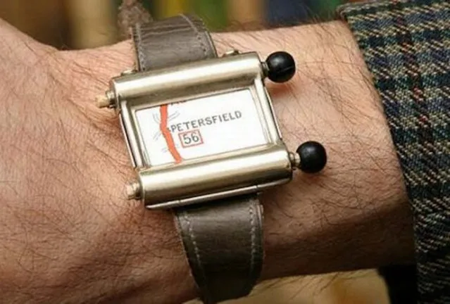
Invented in 1920′s this could be world’s first navigation system. No satellites or digital screens were used in the making of this portable navigation system. Called Plus Fours Routefinder, this little invention was designed to be worn on your wrist, and the “maps” were printed on little wooden rollers which you would turn manually as you drove along.
Details
19 Mar 2014 15:14:00
Fann Mountains In Tajikistan

Fann Mountains are part of the western Pamir-Alay mountain system and are located in Tajikistan's Sughd Province between the Zarafshan Range to the north and the Gissar Range to the south (see map of Fann Mountains). In the east-west direction they extend from Fandarya River to Archimaydan River, and the cluster of Marguzor lakes west of Archimaydan is also included in the Fanns.
Details
29 May 2013 11:45:00
Team China performs during the team free routine artistic swimming competition at the 19th Asian Games in Hangzhou, China, Sunday, October 8, 2023. (Photo by Aaron Favila/AP Photo)

Team China performs during the team free routine artistic swimming competition at the 19th Asian Games in Hangzhou, China, Sunday, October 8, 2023. (Photo by Aaron Favila/AP Photo)
Details
20 Oct 2023 00:51:00


People enjoy the fine weather on the coast at Wembury during the first ever nationwide survey to map the location of the threatened and creatures on March 24, 2011 in near Plymouth, England. Often found on the coast, and particularly in the south west of England, the number of oil beetle species found in the UK has halved in the last 100 years and the survey will help establish the whereabouts of the remaining four species and boost efforts to secure their future. The survey is being launched today by Buglife: The Invertebrate Trust and the National Trust in partnership with Natural England and Oxford University Museum of Natural History. (Photo by Matt Cardy/Getty Images)
Details
25 Mar 2011 15:20:00
Members of team China perform during the Artistic Swimming Team Free Final at the FINA Swimming World Championships in Gwangju, South Korea, 19 July 2019. (Photo by Antonio Bat/EPA/EFE/Rex Features/Shutterstock)

Members of team China perform during the Artistic Swimming Team Free Final at the FINA Swimming World Championships in Gwangju, South Korea, 19 July 2019. (Photo by Antonio Bat/EPA/EFE/Rex Features/Shutterstock)
Details
23 Jul 2019 00:01:00
A member of team Japan performs during the women's team free final at the FINA World Championships in Budapest, Hungary on June 24, 2022. (Photo by Marton Monus/Reuters)

A member of team Japan performs during the women's team free final at the FINA World Championships in Budapest, Hungary on June 24, 2022. (Photo by Marton Monus/Reuters)
Details
04 Jul 2022 04:31:00
Grand Canyon Skywalk

The Grand Canyon Skywalk is a transparent horseshoe-shaped cantilever bridge and tourist attraction in Arizona near the Colorado River on the edge of a side canyon in the Grand Canyon West area of the main canyon. USGS topographic maps show the elevation at the Skywalk's location as 4,770 ft (1,450 m) and the elevation of the Colorado River in the base of the canyon as 1,160 ft (350 m), and they show that the height of the precisely vertical drop directly under the skywalk is between 500 ft (150 m) and 800 ft (240 m).
Details
09 Jul 2013 11:57:00
Hotel staff practice self-defence skills after a training session given by team member of Special Weapons and Tactics (SWAT) team, in Hangzhou, Zhejiang province, April 7, 2016. (Photo by Reuters/Stringer)

Hotel staff practice self-defence skills after a training session given by team member of Special Weapons and Tactics (SWAT) team, in Hangzhou, Zhejiang province, April 7, 2016. (Photo by Reuters/Stringer)
Details
12 Apr 2016 11:37:00