Loading...
Done
Bagt Kosgi Ashgabat - Turkmenistan

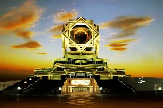
The "Wedding Palace" (Bagt Kosgi) is located in the southwest of Ashgabat. while the building was designed in a sphere shape surrounded by the eight-corner "Oguzkhan Star" on the corners of the building. There is a map of Turkmenistan on the outer space of the sphere whose radius is 32 meters and it can be seen from far away as the sun reflects off it.
Details
18 May 2014 16:37:00
The Doppler on Wheels (DOW) vehicle scans a supercell thunderstorm during a tornado research mission, May 8, 2017 in Elbert County near Agate, Colorado. Doppler on Wheels (DOW) is a mobile doppler radar mounted on a truck that brings instruments directly into storms, allowing scientists to scan storms and tornadoes and make 3-D maps of wind and debris. (Photo by Drew Angerer/Getty Images)

The Doppler on Wheels (DOW) vehicle scans a supercell thunderstorm during a tornado research mission, May 8, 2017 in Elbert County near Agate, Colorado. Doppler on Wheels (DOW) is a mobile doppler radar mounted on a truck that brings instruments directly into storms, allowing scientists to scan storms and tornadoes and make 3-D maps of wind and debris. (Photo by Drew Angerer/Getty Images)
Details
18 May 2017 08:54:00
The cruise ship Viking Sky as it drifts after sending a Mayday signal because of engine failure in windy conditions near Hustadvika, off the west coast of Norway, Saturday March 23, 2019.  The Viking Sky is forced to evacuate its estimated 1,300 passengers. (Photo by Odd Roar Lange/NTB Scanpix via AP Photo)

The cruise ship Viking Sky as it drifts after sending a Mayday signal because of engine failure in windy conditions near Hustadvika, off the west coast of Norway, Saturday March 23, 2019. The Viking Sky is forced to evacuate its estimated 1,300 passengers. (Photo by Odd Roar Lange/NTB Scanpix via AP Photo)
Details
25 Mar 2019 00:05:00
Plus Fours Routefinder - Worlds First Navigation System

Invented in 1920′s this could be world’s first navigation system. No satellites or digital screens were used in the making of this portable navigation system. Called Plus Fours Routefinder, this little invention was designed to be worn on your wrist, and the “maps” were printed on little wooden rollers which you would turn manually as you drove along.
Details
19 Mar 2014 15:14:00
Fann Mountains In Tajikistan

Fann Mountains are part of the western Pamir-Alay mountain system and are located in Tajikistan's Sughd Province between the Zarafshan Range to the north and the Gissar Range to the south (see map of Fann Mountains). In the east-west direction they extend from Fandarya River to Archimaydan River, and the cluster of Marguzor lakes west of Archimaydan is also included in the Fanns.
Details
29 May 2013 11:45:00
Snow covered pine tree reaches for the sky. Shot in Sweden on a crisp winter day. (Photo by Anna Rebecka Lindberg/The Guardian)

Snow covered pine tree reaches for the sky. Shot in Sweden on a crisp winter day. (Photo by Anna Rebecka Lindberg/The Guardian)
Details
20 Apr 2019 00:03:00
The Villarrica volcano lights up the sky at night seen from Pucon town, Chile on December 14, 2023. (Photo by Cristobal Saavedra Escobar/Reuters)

The Villarrica volcano lights up the sky at night seen from Pucon town, Chile on December 14, 2023. (Photo by Cristobal Saavedra Escobar/Reuters)
Details
22 Dec 2023 00:17:00
Six month- old baby elephant “Clear Sky” is kept afloat with the help of a harness during a hydrotherapy session at a local veterinary clinic in Chonburi Province on January 5, 2017. (Photo by Roberto Schmidt/AFP Photo)

Six month- old baby elephant “Clear Sky” is kept afloat with the help of a harness during a hydrotherapy session at a local veterinary clinic in Chonburi Province on January 5, 2017. After losing part of her left foot in a snare in Thailand, baby elephant 'Clear Sky' is now learning to walk again – in water. (Photo by Roberto Schmidt/AFP Photo)
Details
06 Jan 2017 14:06:00