Loading...
Done
A Manipuri woman sells smoked and dry fish in Ima market - the world's largest all women market - in Imphal city, Manipur state, 06 January 2016. The 150-year-old Ima Keithel or 'Mothers's market' complex, which is run exclusively by women and was damaged in the 04 January 2016 earthquake, is returning back to normal. Nine deaths have been reported from in and around Imphal due to falling debris. (Photo by EPA/Stringer)

A Manipuri woman sells smoked and dry fish in Ima market - the world's largest all women market – in Imphal city, Manipur state, 06 January 2016. The 150-year-old Ima Keithel or “Mothers's market” complex, which is run exclusively by women and was damaged in the 04 January 2016 earthquake, is returning back to normal. Nine deaths have been reported from in and around Imphal due to falling debris. Imphal has a population of some 270,000 and people were jolted from their sleep and ran out of their homes in panic when the earth shook 04 January, reports say. (Photo by EPA/Stringer)
Details
08 Jan 2016 08:04:00
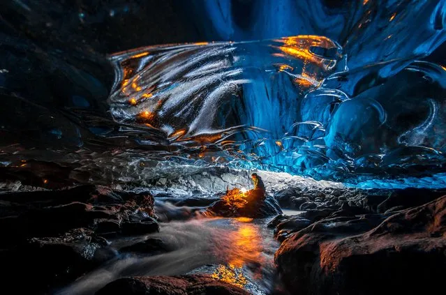
Stunning images have revealed ice-cool British tourists chilling out inside Europe’s largest glacier – despite being at risk of flooding. The spectacular collection of images show the explorers braving the freezing temperatures to climb, photograph and even abseil down the inside of the icy cliff sides. Another image shows one visitor on his knees appearing to pray next to a water fall of melted ice. Other glistening shots show an adventurer trying to keep warm by a fire whose flames dance beautifully against the glossy roof. More shots show the caves sparkling like crystal with one ice formation appearing to resemble bubble wrap. In one picture, a brave tourist stands at the edge of a river flowing through the centre of the frosty caves. (Photo by Einar Runar Sigurdsson/Mediadrumworld.com)

Stunning images have revealed ice-cool British tourists chilling out inside Europe’s largest glacier – despite being at risk of flooding. The spectacular collection of images show the explorers braving the freezing temperatures to climb, photograph and even abseil down the inside of the icy cliff sides. Another image shows one visitor on his knees appearing to pray next to a water fall of melted ice. Other glistening shots show an adventurer trying to keep warm by a fire whose flames dance beautifully against the glossy roof. (Photo by Einar Runar Sigurdsson/Mediadrumworld.com)
Details
03 Dec 2016 11:36:00
In this March 15, 2012 file photo, a Chinese woman poses for photos near a sculpture depicting a Chinese yuan note at an art district in Beijing, China. China devalued its tightly controlled currency on Tuesday, August 11,2015,  following a slump in trade, triggering the yuan's biggest one-day decline in a decade. The central bank said the yuan's 1.3 percent fall was due to a change aimed at making its exchange rate controls more market-oriented. But any change raises the risk of tensions with China's trading partners. (Photo by Ng Han Guan/AP Photo)

In this March 15, 2012 file photo, a Chinese woman poses for photos near a sculpture depicting a Chinese yuan note at an art district in Beijing, China. China devalued its tightly controlled currency on Tuesday, August 11,2015, following a slump in trade, triggering the yuan's biggest one-day decline in a decade. The central bank said the yuan's 1.3 percent fall was due to a change aimed at making its exchange rate controls more market-oriented. But any change raises the risk of tensions with China's trading partners. (Photo by Ng Han Guan/AP Photo)
Details
12 Aug 2015 13:11:00
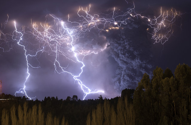
The eruption of Cordon Caulle began on June 4, 2011, located in the Region of Los Rios in Chile. For about 12 months, people and animals became accustomed to living with the daily fall of ash, which also caused problems in the air traffic in South America. The explosions and lightning during first days of the eruption could be seen from hundreds of miles around. This photograph was taken on the second night of eruption from the town of Lago Ranco. (Photo and caption by Francisco Negroni/National Geographic Traveler Photo Contest)

The eruption of Cordon Caulle began on June 4, 2011, located in the Region of Los Rios in Chile. For about 12 months, people and animals became accustomed to living with the daily fall of ash, which also caused problems in the air traffic in South America. The explosions and lightning during first days of the eruption could be seen from hundreds of miles around. This photograph was taken on the second night of eruption from the town of Lago Ranco. (Photo and caption by Francisco Negroni/National Geographic Traveler Photo Contest)

ATTENTION! All pictures are presented in high resolution. To see Hi-Res images – just TWICE click on any picture. In other words, click small picture – opens the BIG picture. Click BIG picture – opens VERY BIG picture.
Details
23 Jun 2013 11:24:00
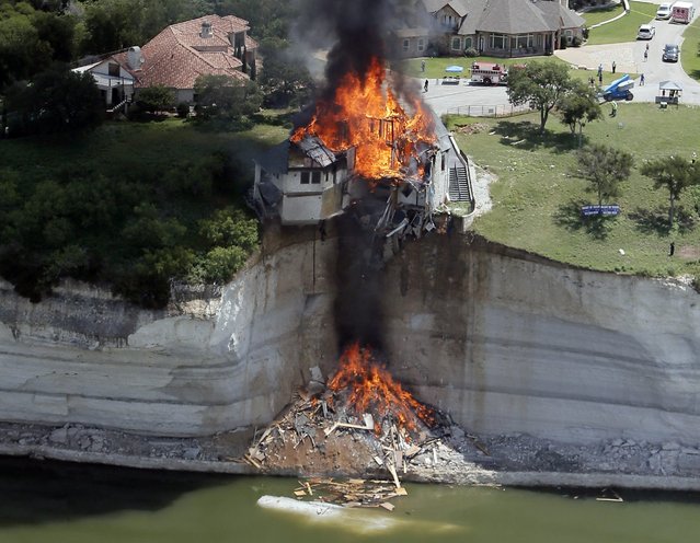
Smoke rises from a house days after part of the ground it was resting on collapsed into Lake Whitney, Texas in this June 13, 2014 file photo. I was covering the controlled burn of a house slowly falling into Lake Whitney due to the decaying cliff underneath.  Asked to take photos from an aerial perspective, an instructor and I took off from Grand Prairie Municipal Airport around 9am. (Photo and caption by Brandon Wade/Reuters)

Smoke rises from a house days after part of the ground it was resting on collapsed into Lake Whitney, Texas in this June 13, 2014 file photo. I was covering the controlled burn of a house slowly falling into Lake Whitney due to the decaying cliff underneath. Asked to take photos from an aerial perspective, an instructor and I took off from Grand Prairie Municipal Airport around 9am. The burn, scheduled to start an hour later, was delayed. I love flying, but patience proved challenging as circling for nearly three hours gets boring fast. Once the fire started we only had 15 minutes to take photos because the plane was booked at 1pm. The owners invested their retirement savings in the house and were even advised by geologists that the ground was stable. To watch your investment literally go up in flames must take its toll emotionally. The owners said they don't expect their insurance to cover the loss. (Photo and caption by Brandon Wade/Reuters)
Details
27 Nov 2014 15:01:00
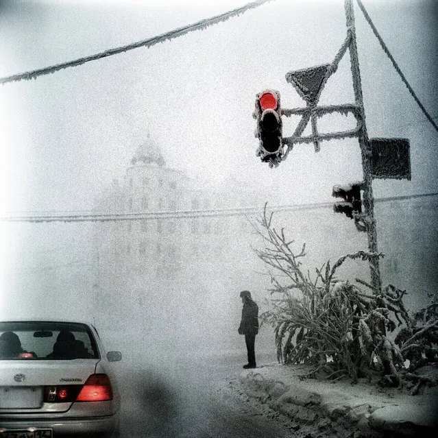
January 2013. A scene in Yakutsk, Siberia, the coldest city in the world. (Photo by Steeve Iuncker/Agence VU)

Yakutsk, a remote city in Eastern Siberia along the Lena River, is the coldest city in the world. Located 1840 km away from Irkoustk and 5000 km away from Moscow, this city founded in 1632 by the Cossacks imposes upon its inhabitants an extreme way of life. And yet, despite particularly harsh conditions, Yakutsk boasts a population of 270,000, or a quarter of the entire population of Siberia. No other place on the planet experiences the temperature extreme found here: in winter, the temperatures regularly fall to minus 40° (the coldest temperature recorded was –64°C) and in summer often reaches temperatures above 30°C. Photo: January 2013. A scene in Yakutsk, Siberia, the coldest city in the world. (Photo by Steeve Iuncker/Agence VU)
Details
29 Apr 2013 10:30:00
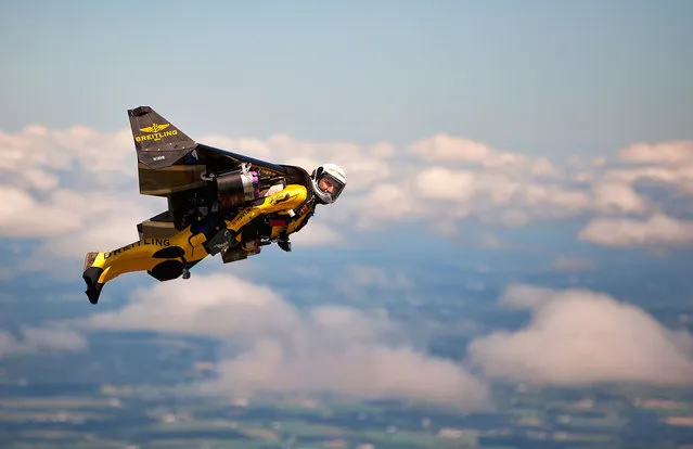
Jetman during a trial flight from Fond du Lac airport on Monday July 29, 2013. While skydiving several years ago Yves Rossy thought it would be cool to not just fall to earth but fly around with a jetpack on his back. So he invented one and will jump out of a helicopter over Oshkosh on Tuesday at AirVenture air and zoom around in his jetpack, his first public appearance in the U.S. (Photo by Mike Shore/Courtesy of Breitling)

Yves “Jetman”, Rossy made his first public performance in the United States on Tuesday during the afternoon air show at EAA AirVenture. As thousands of spectators leaned back and clicked cameras, Rossy jumped out of a helicopter with his 6-foot carbon fiber wing armed with four 45-pound-thrust JetCat engines strapped to his back. Photo: Jetman during a trial flight from Fond du Lac airport on Monday July 29, 2013. (Photo by Mike Shore/Courtesy of Breitling)
Details
31 Jul 2013 13:05:00
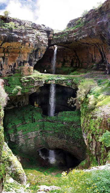
Baatara Gorge Waterfall

Discovered in 1952 by French bio-speleologist Henri Coiffait, the waterfall and accompanying sinkhole were fully mapped in the 1980s by the Spéléo club du Liban. The cave is also known as the "Cave of the Three Bridges." Traveling from Laklouk to Tannourine one passes the village of Balaa, and the "Three Bridges Chasm" (in French "Gouffre des Trois Ponts") is a five-minute journey into the valley below where one sees three natural bridges, rising one above the other and overhanging a chasm descending into Mount Lebanon. During the spring melt, a 90–100-metre (300–330 ft) cascade falls behind the three bridges and then down into the 250-metre (820 ft) chasm. A 1988 fluorescent dye test demonstrated that the water emerged at the spring of Dalleh in Mgharet al-Ghaouaghir.
Details
31 Aug 2013 11:27:00