Loading...
Done
Police investigators inspect the bodies of two men lying on a sidewalk, who police said were killed after a drug “Shabu” (Methamphetamine Chloride) buy-bust operation in Quezon city, Metro Manila Philippines, October 9, 2016. (Photo by Ezra Acayan/Reuters)

Police investigators inspect the bodies of two men lying on a sidewalk, who police said were killed after a drug “Shabu” (Methamphetamine Chloride) buy-bust operation in Quezon city, Metro Manila Philippines, October 9, 2016. (Photo by Ezra Acayan/Reuters)
Details
10 Oct 2016 10:11:00
Natural gas plant in Pittsburg, CA (detail of Power Landscape), 2013. (Photo by Jenny Odell)

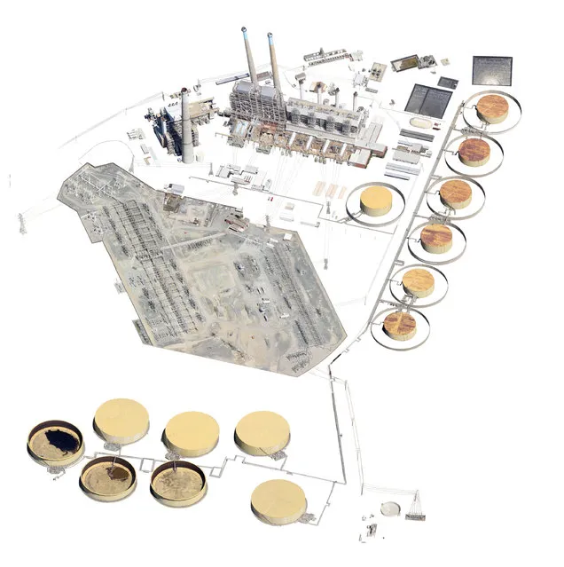
Jenny Odell repurposes online imagery mostly from Google Maps, but also from YouTube, Craigslist, and other sites. In her “Satellite Collections”, for example, she incorporated aerial views of swimming pools, basketball courts, parking lots, and other recognizable structures, seen from space. Her more recent series, “Satellite Landscapes”, includes painstakingly isolated Google Maps imagery of oil refineries, wastewater treatment plants, solar farms, etc. This work is meant as a reminder of our physically determined and vulnerable existence, since we depend on many of these things for survival and maintenance of our way of life. Photo: Natural gas plant in Pittsburg, CA (detail of Power Landscape), 2013. (Photo by Jenny Odell)
Details
19 Mar 2014 07:28:00
These stunning coloured images show detailed x-ray images of everything from skulls to light bulbs. Artist Paula Fontaine, from Westminster Massachusetts, created the images using a process called digital map painting. Here: Brain storm, conceptual composite X-ray. (Photo by Paula Fontaine/Barcroft Media)

These stunning coloured images show detailed x-ray images of everything from skulls to light bulbs. Artist Paula Fontaine, from Westminster Massachusetts, created the images using a process called digital map painting. To create the images the x-ray emission source – the head of the machine on an arm which focuses the beam – is placed over the object. Paula then retreats behind a shielded screen before activating the x-ray exposure. Here: Brain storm, conceptual composite X-ray. (Photo by Paula Fontaine/Barcroft Media)
Details
27 Mar 2015 13:34:00
This watering hole is the social hub of the veldt; the scrubby grasslands that stretch across Namibia. The scorched earth supports sometimes fragile populations of magnificent wildlife – from endangered predators to plentiful herds of game. But these gentle giraffes and elephants need to be careful: lions don’t sleep at night, they hunt! The spectacular starscape above southern Africa is unchanged since explorers first mapped the continent. The photographer, Pietro Olivetta from Italy, said he had to be patient to capture these shots – but it was worth the wait. (Photo by Pietro Olivetta/Caters News)

This watering hole is the social hub of the veldt; the scrubby grasslands that stretch across Namibia. The scorched earth supports sometimes fragile populations of magnificent wildlife – from endangered predators to plentiful herds of game. But these gentle giraffes and elephants need to be careful: lions don’t sleep at night, they hunt! The spectacular starscape above southern Africa is unchanged since explorers first mapped the continent. The photographer, Pietro Olivetta from Italy, said he had to be patient to capture these shots – but it was worth the wait. (Photo by Pietro Olivetta/Caters News)
Details
20 Feb 2017 00:05:00
The Doppler on Wheels (DOW) vehicle scans a supercell thunderstorm during a tornado research mission, May 8, 2017 in Elbert County near Agate, Colorado. Doppler on Wheels (DOW) is a mobile doppler radar mounted on a truck that brings instruments directly into storms, allowing scientists to scan storms and tornadoes and make 3-D maps of wind and debris. (Photo by Drew Angerer/Getty Images)

The Doppler on Wheels (DOW) vehicle scans a supercell thunderstorm during a tornado research mission, May 8, 2017 in Elbert County near Agate, Colorado. Doppler on Wheels (DOW) is a mobile doppler radar mounted on a truck that brings instruments directly into storms, allowing scientists to scan storms and tornadoes and make 3-D maps of wind and debris. (Photo by Drew Angerer/Getty Images)
Details
18 May 2017 08:54:00
epaselect epa05234254 A model presents a creation from the Beijing Institute of Fashion Technology Emerging Design Collection at the “BIFT ELLASSAY” Scholarship Awarding Ceremony during the Mercedes-Benz China Fashion Week at the Beijing Hotel, in Beijing, China, 29 March 2016. (Photo by Wu Hong/EPA)

epaselect epa05234254 A model presents a creation from the Beijing Institute of Fashion Technology Emerging Design Collection at the “BIFT ELLASSAY” Scholarship Awarding Ceremony during the Mercedes-Benz China Fashion Week at the Beijing Hotel, in Beijing, China, 29 March 2016. (Photo by Wu Hong/EPA)
Details
03 Apr 2016 12:03:00
Fann Mountains In Tajikistan

Fann Mountains are part of the western Pamir-Alay mountain system and are located in Tajikistan's Sughd Province between the Zarafshan Range to the north and the Gissar Range to the south (see map of Fann Mountains). In the east-west direction they extend from Fandarya River to Archimaydan River, and the cluster of Marguzor lakes west of Archimaydan is also included in the Fanns.
Details
29 May 2013 11:45:00
Plus Fours Routefinder - Worlds First Navigation System

Invented in 1920′s this could be world’s first navigation system. No satellites or digital screens were used in the making of this portable navigation system. Called Plus Fours Routefinder, this little invention was designed to be worn on your wrist, and the “maps” were printed on little wooden rollers which you would turn manually as you drove along.
Details
19 Mar 2014 15:14:00