Loading...
Done
A man feeds a seagull during a record low tide in Saint Malo, western France, March 21, 2015. (Photo by Stephane Mahe/Reuters)

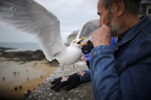
A man feeds a seagull during a record low tide in Saint Malo, western France, March 21, 2015. Towns on France's North Atlantic coast braced for their first giant tide of the millennium on Saturday as the full moon and this week's solar eclipse combined to create an ocean surge not seen since 1997. (Photo by Stephane Mahe/Reuters)
Details
22 Mar 2015 10:37:00
Workers harvest cranberries from one of third-generation farmer Larry Harju's bogs in Carver, Massachusetts, U.S. October 14, 2016. (Photo by Brian Snyder/Reuters)

Workers harvest cranberries from one of third-generation farmer Larry Harju's bogs in Carver, Massachusetts, U.S. October 14, 2016. The cranberries from Harju’s farm are a part of the 8 million barrels of cranberries Ocean Spray anticipates is grower-owners will produce this year. (Photo by Brian Snyder/Reuters)
Details
15 Oct 2016 10:45:00
Wave Rock, Arizona

Wave Rock is a natural rock formation that is shaped like a tall breaking ocean wave. The "wave" is about 14 m (46 ft) high and around 110 m (360 ft) long. It forms the north side of a solitary hill, which is known as “Hyden Rock”. This hill, which is a granite inselberg, lies about 3 km (2 mi) east of the small town of Hyden and 296 km (184 mi) east-southeast of Perth, Western Australia. Wave Rock and Hyden Rock are part of a 160 ha (395-acre) nature reserve, Hyden Wildlife Park.
Details
12 Aug 2014 10:21:00
The Great Dismal Swamp

The Great Dismal Swamp is a marshy area in the Coastal Plain Region of southeastern Virginia and northeastern North Carolina, between Norfolk, Virginia, and Elizabeth City, North Carolina. It is located in parts of southern Virginia cities Chesapeake and Suffolk and northern North Carolina counties Gates, Pasquotank and Camden. It is a southern swamp, one of many along the Atlantic Ocean's coast, including the Everglades and Big Cypress Swamp in Florida, the Okefenokee Swamp in Georgia, the Congaree and Four Holes swamps of South Carolina, and some of the Carolina bays in the Carolinas and Georgia. Along the eastern edge runs the Dismal Swamp Canal, completed in 1805.
Details
09 Dec 2013 11:40:00
The Archerfish

The archerfish (spinner fish or archer fish) are a family (Toxotidae) of fish known for their habit of preying on land based insects and other small animals by literally shooting them down with water droplets from their specialized mouths. The family is small, consisting of seven species in the genus Toxotes; which typically inhabit brackish waters of estuaries and mangroves, but can also be found in the open ocean as well as far upstream in fresh water They can be found from India to the Philippines, Australia, and Polynesia.
Details
21 Nov 2012 12:54:00


In this handout image provided by the National Oceanic and Atmospheric Administration (NOAA), model runs from the Center for Tsunami Research at the NOAA Pacific Marine Environmental Laboratory show the expected wave heights of the tsunami as it travels across the Pacific basin March 11, 2011. The largest wave heights are expected near the earthquake epicenter, off Japan. The wave will decrease in height as it travels across the deep Pacific but grow taller as it nears coastal areas. In general, as the energy of the wave decreases with distance, the near shore heights will also decrease (e.g., coastal Hawaii will not expect heights of that encountered in coastal Japan). (Photo by NOAA via Getty Images)
Details
13 Mar 2011 14:29:00
Rock Fishing In Sydney

A fisherman is seen standing on a cliff edge at Cape Bank in La Perouse on February 20, 2011 in Sydney, Australia. The practice of fishing from rock platforms, cliffs and rocky outcrops is notoriously dangerous with many anglers per year being washed into the ocean by dangerous surf or unexpected large waves. Angling is often reported as the sport having the highest mortality rate on average due to fishermen drowning with rocking fishing contributing to a high number of these deaths. (Photo by Mark Kolbe/Getty Images)
Details
16 Aug 2011 11:34:00
Hurricane Irene

In this handout GOES satellite image provided by the National Oceanic and Atmospheric Administration (NOAA), Irene reaches hurricane strength as it moves across Puerto Rico towards Hispaniola August 22, 2011 in the Caribbean Sea. Irene, the first hurricane of the Atlantic storm season, brought torrential rains and winds to Puerto Rico, downing trees and powerlines and flooding streets. The expected path will bring Irene through the Bahamas and is likely to hit Florida and up the east coast of the U.S. (Photo by NOAA via Getty Images)
Details
23 Aug 2011 12:47:00