A model walks along the Edge observation deck in the city’s Hudson Yards district on World Photography Day in New York on August 19, 2023. (Photo by Lev Radin/Pacific Press/Rex Features/Shutterstock)
A woman cries as she stands next to house destroyed by the earthquake in the Pacific coastal town of Pedernales, Ecuador, Sunday, April 17, 2016. A magnitude-7.8 quake, the strongest since 1979, hit Ecuador flattening buildings, buckling highways along its Pacific coast and killing hundreds. (Photo by Dolores Ochoa/AP Photo)
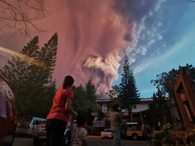
The Taal Volcano in the central Philippines boomed to life on Sunday, January 12, 2020 spilling ash and causing evacuations in nearby communities – and officials warn that a more powerful eruption is imminent. One of the world’s smallest volcanoes, Taal is among two dozen active volcanoes in the Philippines, which lies along the so-called Pacific Ring of Fire, a seismically active region that is prone to earthquakes and volcanic eruptions. (Photo by Kester Ragaza/Pacific Press/Rex Features/Shutterstock)
In this handout image provided by the National Oceanic and Atmospheric Administration (NOAA), model runs from the Center for Tsunami Research at the NOAA Pacific Marine Environmental Laboratory show the expected wave heights of the tsunami as it travels across the Pacific basin March 11, 2011. The largest wave heights are expected near the earthquake epicenter, off Japan. The wave will decrease in height as it travels across the deep Pacific but grow taller as it nears coastal areas. In general, as the energy of the wave decreases with distance, the near shore heights will also decrease (e.g., coastal Hawaii will not expect heights of that encountered in coastal Japan). (Photo by NOAA via Getty Images)