Loading...
Done
Split Apple Rock

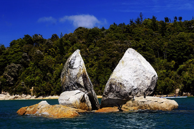
Split Apple Rock is a geological rock formation in The Tasman Bay off the northern coast of the South Island of New Zealand. Made of granite, it is in the shape of an apple which has been cut in half. It is a popular tourist attraction in the waters of the Tasman Sea approximately 50 metres off the coast between Kaiteriteri and Marahau. The rock sits in shallow water at low tide and is accessible by wading. It is also a point of interest for the many tourist boats and pleasure craft which operate along the shores of the Abel Tasman National Park. The cleft to produce two sides of the 'apple' was a natural occurrence. It is unknown when this happened and therefore the cleaving of the rock has attracted mythological explanations.
Details
19 Oct 2013 10:58:00
A Hindu holy man on his way to the annual holy dip at Gangasagar, gestures towards a visitor as he rests at a transit camp in Kolkata, India, Wednesday, January 6, 2016. (Photo by Bikas Das/AP Photo)

A Hindu holy man on his way to the annual holy dip at Gangasagar, gestures towards a visitor as he rests at a transit camp in Kolkata, India, Wednesday, January 6, 2016. Thousands of Hindu pilgrims are expected to take the annual holy dip at Gangasagar, where the Ganges River reaches the Bay of Bengal, on the auspicious Makar Sankranti festival day that falls on Jan.14. (Photo by Bikas Das/AP Photo)
Details
10 Jan 2016 08:06:00
A car rolls south along the Dalton Highway near Coldfoot, Alaska, USA, 03 September 2017. (Photo by Jim Lo Scalzo/EPA)

A car rolls south along the Dalton Highway near Coldfoot, Alaska, USA, 03 September 2017. Stretching 414 miles (666 kilometers) north from central Alaska to Prudhoe Bay, the Dalton Highway is one of America's northernmost roads and arguably its most remote. (Photo by Jim Lo Scalzo/EPA)
Details
09 Oct 2017 08:01:00
Metal Cats By Alexandra Crockett

Alexandra Crockett, a musician and jewelry designer, has been present and active in the metal community since the age of 15 and is currently a doctoral student in the Bay Area. Beginning her idea for the book by doing promotional photos for bands and friends she would cat-sit for, she found an interesting dynamic between men in the metal scene and their cats. The idea for the book formed around giving accolades to local musicians and artists in the metal scene, while also bringing to light no-kill shelters and their importance for animal rights.
Details
08 Sep 2014 08:47:00
Images of an American ghost town that was home to gold mines and features a plane which crashed during the filming of 3000 Miles to Graceland starring Kevin Costner and Kurt Russell reveal the remnants of the once thriving location. An assortment of rusted vehicles which include a canary yellow bus, caravans and cars have all been left behind in the desert. Other pictures of Nelson, Nevada show its desolate surroundings with only a couple of houses and museums scattered around the area. In one shot, a derelict petrol pump stands still after making its final sale years ago. The stunning photographs were taken by an American photographer known as Abandoned Southeast on a visit to Nelson, Nevada. The area was called Eldorado by the Spaniards who made the original discoveries of gold in the town. The notorious Techatticup gold and silver mine which was associated with crime and murders ran in the area from 1861 to 1942. It was the richest mine in Southern Nevada. (Photo by Abandoned Southeast/Mediadrumworld.com)

Images of an American ghost town that was home to gold mines and features a plane which crashed during the filming of 3000 Miles to Graceland starring Kevin Costner and Kurt Russell reveal the remnants of the once thriving location. An assortment of rusted vehicles which include a canary yellow bus, caravans and cars have all been left behind in the desert. (Photo by Abandoned Southeast/Mediadrumworld.com)
Details
25 Dec 2016 09:25:00
Winner – Animal Portraits: The pose by Mogens Trolle, Denmark. A young male proboscis monkey cocks his head slightly and closes his eyes. Unexpected pale blue eyelids now complement his immaculately groomed auburn hair. He poses for a few seconds as if in meditation. He is a wild visitor to the feeding station at Labuk Bay Proboscis Monkey Sanctuary in Sabah, Borneo – “the most laid-back character”, says Trolle, “quite unlike anything I’ve ever seen on another monkey” – connects us, he hopes, with a fellow primate. (Photo by Mogens Trolle/Wildlife Photographer of the Year 2020)

Winner – Animal Portraits: The pose by Mogens Trolle, Denmark. A young male proboscis monkey cocks his head slightly and closes his eyes. Unexpected pale blue eyelids now complement his immaculately groomed auburn hair. He poses for a few seconds as if in meditation. He is a wild visitor to the feeding station at Labuk Bay Proboscis Monkey Sanctuary in Sabah, Borneo – “the most laid-back character”, says Trolle, “quite unlike anything I’ve ever seen on another monkey” – connects us, he hopes, with a fellow primate. (Photo by Mogens Trolle/Wildlife Photographer of the Year 2020)
Details
16 Oct 2020 00:03:00
Aerial view of the salt ponds in San Francisco, California. (Photo by Cris Benton/Caters News)

These spectacular landscapes may look like something from another planet – but they are in fact colorful salt ponds which stretch for miles. Despite being better known for tech companies and expensive property – San Francisco, California is also home to this vibrant quilt of color spanning the South Bay Area. From eerie green pools to gothic shades of red the surreal landscapes are caused by the organisms or micro-algae living within them. Photo: Aerial view of the salt ponds in San Francisco, California. (Photo by Cris Benton/Caters News)
Details
02 Jul 2014 10:18:00
Underground River

The Puerto Princesa Subterranean River National Park is located about 50 kilometres (30 mi) north of the city centre of Puerto Princesa, Palawan, Philippines. The river is also called Puerto Princesa Underground River. The national park is located in the Saint Paul Mountain Range on the northern coast of the island. It is bordered by St. Paul Bay to the north and the Babuyan River to the east. The City Government of Puerto Princesa has managed the National Park since 1992. The park is also known as St. Paul's Subterranean River National Park, or St. Paul Underground River. The entrance to the Subterranean River is a short hike from the town of Sabang.
Details
16 Jul 2012 11:37:00