Loading...
Done
RT-2PM2 Topol-M TEL with presumably Yars system transport-launch container

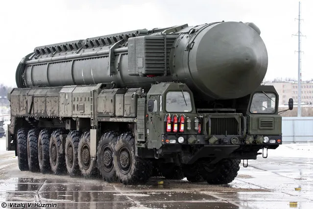
“March 19, 2012 was the first rehearsal for the Victory Day Parade at the training ground in Alabino (near Moscow, Moscow Military District). Since the end of February troops and vehicles from various units and formations of the Armed Forces began arriving to Alabino training ground. The first rehearsal included only military vehicles. During the ride the average speed of vehicles is 12 km/h, the distance depending on the type of vehicle from 12 to 15 meters”. – Vitaly Kuzmin
Details
15 Apr 2012 12:50:00
Festival goers plays in mud during the 15th Annual Boryeong Mud Festival at Daecheon beach in Boryeong, southwest of Seoul

Festival goers plays in mud during the 15th Annual Boryeong Mud Festival at Daecheon beach in Boryeong, about 190 km (118 miles) southwest of Seoul, July 15, 2012. About 2 to 3 million domestic and international tourists visit the beach during the annual mud festival, according to the festival organisation. (Photo by Chung Sung-Jun)
Details
16 Jul 2012 08:45:00


Gohei Hayashi of Kyoto University is seen in side his movable eco and healing house, “Kujira (Whale) House” July 21, 2007 in Tokyo, Japan. The house is made from Japanese paper, bamboo and tatami mat. Hayashi has travelled 500 km from Japan's ancient city, Kyoto to Tokyo with his eco house to promote his house which can be placed both out inside and outside to provide a private space. The Kujira house is available at the price of 800,000 yen (roughly US$6600). (Photo by Koichi Kamoshida/Getty Images)
Details
23 May 2011 06:45:00
Buddhist pilgrim family from Sichuan. (Photo by Tom Carter/The Atlantic)

Nine years ago, Tom Carter traveled from San Francisco to China, responding to a job posting that turned out to be a scam. He managed to find another job as a teacher, and saved enough money to embark on a 56,000 km trip through all of China's 33 provinces that lasted two years. Carrying a camera – just a a 4-megapixel point-and-shoot – Carter captured some amazing images of the widely varying landscape, people, and architecture across the nation. Photo: Buddhist pilgrim family from Sichuan. (Photo by Tom Carter via The Atlantic)
Details
12 Mar 2013 14:19:00
Gunung Leuser National Parkr"

Gunung Leuser National Park is a national park covering 7,927 km² in northern Sumatra, Indonesia, straddling the border of North Sumatra and Aceh provinces. The national park, named after Mount Leuser (3,381 m), protects a wide range of ecosystems. An orangutan sanctuary of Bukit Lawang is located inside the park. Together with Bukit Barisan Selatan and Kerinci Seblat national parks it forms a World Heritage Site, Tropical Rainforest Heritage of Sumatra.
Details
14 Jul 2013 10:28:00
Visitors walk on the Giant's Causway in Portrush, Northern Ireland

“The Giant's Causeway is an area of about 40,000 interlocking basalt columns, the result of an ancient volcanic eruption. It is located in County Antrim on the northeast coast of Northern Ireland, about three miles (4.8 km) northeast of the town of Bushmills. It was declared a World Heritage Site by UNESCO in 1986, and a National Nature Reserve in 1987 by the Department of the Environment for Northern Ireland”. – Wikipedia

Photo: Visitors walk on the Giant's Causway on March 14, 2012 in Portrush, Northern Ireland. (Photo by Peter Macdiarmid/Getty Images)
Details
17 Mar 2012 11:10:00
Local residents evacuate onto a street minutes after an earthquake in central Kathmandu, Nepal, May 12, 2015. (Photo by Athit Perawongmetha/Reuters)

Local residents evacuate onto a street minutes after an earthquake in central Kathmandu, Nepal, May 12, 2015. A 7.3 magnitude earthquake killed at least 37 people and spread panic in Nepal on Tuesday, bringing down buildings already weakened by a devastating tremor less than three weeks ago and unleashing landslides in Himalayan valleys near Mount Everest. The earthquake was centered 76 km (47 miles) east of the capital in a hilly area close to the border with Tibet, according to coordinates provided by the U.S. Geological Survey. (Photo by Athit Perawongmetha/Reuters)
Details
13 May 2015 11:36:00
Lake Assal Crater Lake In The Central Djibouti

Lake Assal is a crater lake in central-western Djibouti. It is located at the western end of Gulf of Tadjoura in the Tadjoura Region, touching Dikhil Region, at the top of the Great Rift Valley, some 120 km (75 mi) west of Djibouti city. Lake Assal is a saline lake which lies 155 m (509 ft) below sea level in the Afar Triangle, making it the lowest point on land in Africa and the third-lowest land depression on Earth after the Dead Sea and Sea of Galilee.
Details
15 Jul 2015 10:19:00