Loading...
Done
Plitvice Lakes National Park

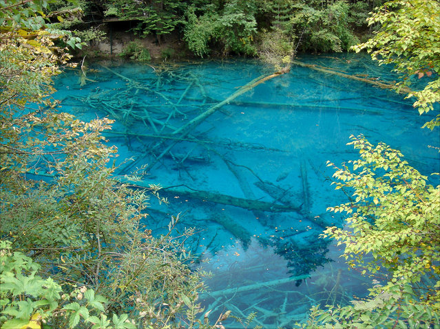
Plitvice Lakes National Park is the oldest national park in Southeast Europe and the largest national park in Croatia. The national park was founded in 1949 and is situated in the mountainous karst area of central Croatia, at the border to Bosnia and Herzegovina. The important north-south road connection, which passes through the national park area, connects the Croatian inland with the Mediterranean coastal region.
Details
12 Aug 2012 16:42:00
The Sifaka jumps along the road. (Photo by Shannon Wild/Caters News Agency)

The Verreauxs Sifaka, otherwise known as Dancing Sifaka, who was caught strutting its stuff in Madagascar, has definitely learnt a lesson or two from King Julian – from the 2005 film “Madagascar”. Raising both of its arms and lunging from side to side, this lemur definitely likes to move it, move it. (Photo by Shannon Wild/Caters News Agency)
Details
24 Jan 2018 06:17:00
Robert Rickhoff  By "Out Of Place"

German artist Robert Rickhoff re-interprets the idea of public space with humor through a series of digitally manipulated photographs in a project entitled “out of place”. Rickhoff augments scenes within a seemingly commonplace environment to depict impractical yet lighthearted situations – including a playground slippery dip facing towards a busy road to a speed bump placed in an unassuming residential street that is actually a daredevil ramp. the visualizations are subtle yet provocative, forcing the audience to look twice to notice the unusual setting infused with tongue-in-cheek wit.
Details
17 Feb 2013 11:43:00
Monument of Buzludja

Buzludzha is a historical peak in the Central Stara Planina, Bulgaria and is 1441 metres high. In 1868 it was the place of the final battle between Bulgarian rebels led by Hadji Dimitar and Stefan Karadzha and the Ottoman Empire. The Buzludzha Monument on the peak was built by the Bulgarian communist regime to commemorate the events in 1891 when the socialists led by Dimitar Blagoev assembled secretly in the area to form an organised socialist movement with the founding of the Bulgarian Social Democratic Party, a fore-runner of the Bulgarian Communist Party. The Monument was opened in 1981. No longer maintained by the Bulgarian government, it has fallen into disuse. Buzludzha is reached by a 12 km side road from the Shipka Pass.
Details
12 Nov 2013 08:16:00
Two men help each other cross a street covered in deep mud in Copiapo, Chile, Thursday, March 26, 2015. (Photo by Pablo Sanhueza/AP Photo)

Two men help each other cross a street covered in deep mud in Copiapo, Chile, Thursday, March 26, 2015. Unusually heavy thunder storms and torrential rains that began on Tuesday have blocked roads, caused power outages and affected some 600 people on this normally dry region. (Photo by Aton Chile/Marcelo Hernandez/AP Photo)
Details
27 Mar 2015 12:52:00


Defined according to wikipedia it is “a recent and informal geologic chronological term that serves to mark the evidence and extent of human activities that have had a significant global impact on the Earth’s ecosystems. The term was coined by ecologist Eugene Stoermer but has been widely popularized by the Nobel Prize-winning atmospheric chemist Paul Crutzen.”

The images here where created by Felix Pharand-Deschenes depicting how various human influences, from road and rail, to internet cables and airlines create significant patterns covering the Earth. What can we learn from these patterns in how they are influencing the environment
Details
19 Aug 2012 10:40:00
Path to the shine. (Ildiko Neer)

“I bought my first dlsr camera in 2009 may. The first part of my life is gone but the other i dedicate to photography. If i try to imagine myself, i saw someone on the road, who walking straight to the light. This kind of light is the photography and the post-processing in my life. My pictures express the feelings, moods what i felt under my trip in the last few years”. – Ildiko Neer

Photo: “Path to the shine”, 2011. (Photo by Ildiko Neer)


Details
12 Dec 2012 06:39:00


People look on as water from the rising Mississippi River is released through the Bonnet Carre Spillway while washing out a road May 9, 2011 in Norco, Louisiana. The Army Corps of Engineers began redirecting part of the Mississippi River through the spillway today to lower river levels and reduce pressure on levees in order to avoid a catastrophic failure. The water will flow nearly 6 miles north before emptying into Lake Pontchartrain as the Mississippi rises close to the highest level ever upriver in Memphis. (Photo by Mario Tama/Getty Images)
Details
11 May 2011 10:11:00