Loading...
Done
The French Riveria of Cannes, France. (Photo by Airpano/Caters News)

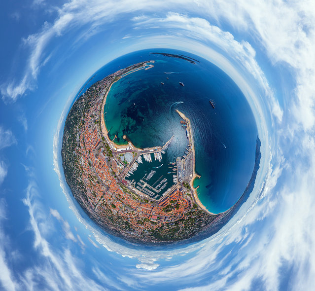
Some of the worlds most iconic cities have been photographed as youve never seen them before in the shape of tiny round planets. By using a pioneering method of aerial photography, each location can be now seen at a full 360 degree angle. After some skilful manipulation on Photoshop known technically as stereographic projection, each sweeping panorama is then turned into a small circular shaped image. Whether its the Eiffel Tower, The Empire State Building or the Shanghai Skyline, each image manages to show hundreds of miles of city landscape. Here: the French Riveria of Cannes, France. (Photo by Airpano/Caters News)
Details
25 Mar 2015 12:14:00
Members of a music band rest before the procession of “Nossa Senhora da Boa Viagem”, in Constancia April 6, 2015. (Photo by Rafael Marchante/Reuters)

Members of a music band rest before the procession of “Nossa Senhora da Boa Viagem”, in Constancia April 6, 2015. This benediction has been held annually for about 200 years. In the past, goods were transported by the Tagus river in small boats to Lisbon, 100 km south. The sailors, as the navigation was dangerous, blessed their boats every year during the festivity of “Nossa Senhora da Boa Viagem”. (Photo by Rafael Marchante/Reuters)
Details
07 Apr 2015 11:14:00
A reveller plays with tomato pulp during the annual Tomatina festival in Bunol, near Valencia, Spain on August 29, 2018. (Photo by Heino Kalis/Reuters)

A reveller plays with tomato pulp during the annual Tomatina festival in Bunol, near Valencia, Spain on August 29, 2018. As every year on the last Wednesday of August, thousands of people visit the small village of Bunol to attend the Tomatina, a battle in which tons of ripe tomatoes are used as weapons. This year, a total of 145 tons of ripe tomatoes will be thrown between more than 22,000 participants. (Photo by Heino Kalis/Reuters)
Details
05 Sep 2018 09:00:00
This November 11, 2014 aerial photo, shows a deforested area dotted with blue tarps, marking the area where miners reside, and craters filled with water, caused by illegal gold mining activities, in La Pampa, in Peru's Madre de Dios region. (Photo by Rodrigo Abd/AP Photo)

This November 11, 2014 aerial photo, shows a deforested area dotted with blue tarps, marking the area where miners reside, and craters filled with water, caused by illegal gold mining activities, in La Pampa, in Peru's Madre de Dios region. Less than a month before Peru plays host to global climate talks, the government sent a battalion of police into southeastern jungles to dismantle illegal gold-mining mining camps. Peru's anti-illegal mining czar, retired army Gen. Augusto Soto, marched the men to the wasteland known as La Pampa, where 50,000 hectares of rainforest have been obliterated in the past six years. (Photo by Rodrigo Abd/AP Photo)
Details
21 Nov 2014 12:35:00
Test of the surface-to-air missile Pantsir-S rocket and gun system

“Pantsir-S1 (NATO reporting name SA-22 Greyhound) is a combined short to medium range surface-to-air missile and anti-aircraft artillery weapon system produced by KBP of Tula, Russia. The system is a further development of SA-19/SA-N-11 and represents the latest air defence technology by using phased-array radars for both target acquisition and tracking”. – Wikipedia

Photo: Test of the surface-to-air missile Pantsir-S rocket and gun system in the conditions of the Polar region on the range “Pemba” near Vorkuta, approximately on October 20 2012. According to the statement of military, during doctrines five cruise missiles from five were destroyed. (Photo by Alexey Reznichenko)

Details
28 Oct 2012 11:27:00


“The Berlin Wall (German: Berliner Mauer) was a barrier constructed by the German Democratic Republic (GDR, East Germany) starting on 13 August 1961, that completely cut off West Berlin from surrounding East Germany and from East Berlin. The barrier included guard towers placed along large concrete walls, which circumscribed a wide area (later known as the “death strip”) that contained anti-vehicle trenches, “fakir beds” and other defenses. The Soviet-dominated Eastern Bloc officially claimed that the wall was erected to protect its population from fascist elements conspiring to prevent the “will of the people” in building a socialist state in East Germany. However, in practice, the Wall served to prevent the massive emigration and defection that marked Germany and the communist Eastern Bloc during the post-World War II period”. – Wikipedia

Photo: West Berlin policemen and East German Volkspolizei face each other across the border in Berlin, circa 1955. (Photo by Three Lions/Hulton Archive/Getty Images)
Details
22 May 2011 10:49:00
“Fly cap for a vine snake”. A fly lands on the head of a vine snake in the Choco of Colombia. (Photo and caption by Robin Moore/National Geographic Traveler Photo Contest)

“Fly cap for a vine snake”. A fly lands on the head of a vine snake in the Choco of Colombia. (Photo and caption by Robin Moore/National Geographic Traveler Photo Contest)

ATTENTION! All pictures are presented in high resolution. To see Hi-Res images – just TWICE click on any picture. In other words, click small picture – opens the BIG picture. Click BIG picture – opens VERY BIG picture.
Details
24 Jun 2013 11:36:00
“Stacked Supercell with Lightning”. This huge mesocyclone supercell was near the Nebraska / Kansas border on the night of June 22nd, 2012. What a stunning structure! (Photo and caption by Jennifer Brindley/National Geographic Traveler Photo Contest)

“Stacked Supercell with Lightning”. This huge mesocyclone supercell was near the Nebraska / Kansas border on the night of June 22nd, 2012. What a stunning structure! (Photo and caption by Jennifer Brindley/National Geographic Traveler Photo Contest)

ATTENTION! All pictures are presented in high resolution. To see Hi-Res images – just TWICE click on any picture. In other words, click small picture – opens the BIG picture. Click BIG picture – opens VERY BIG picture.
Details
25 Jun 2013 13:12:00