Loading...
Done


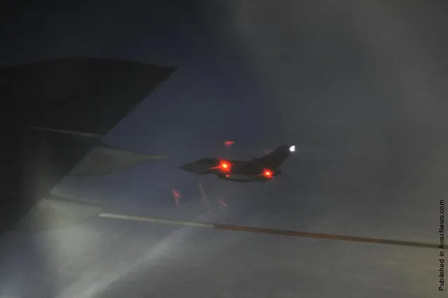
In this handout from the Ministry of Defence, Royal Air Force VC10 and Tristar air-to-air refuelling aircraft support the first UK air combat mission in support of UN Resolution 1973 in flight on March 19, 2011. Col Muammar Gaddafi has vowed a “long war” against the “crusader aggression” after over 100 missiles were fired by the US and UK, during multi-national action aimed at enforcing a UN-mandated no-fly zone. (Photo by SAC Neil Chapman/MoD via Getty Images)
Details
21 Mar 2011 08:39:00
Bagt Kosgi Ashgabat - Turkmenistan

The "Wedding Palace" (Bagt Kosgi) is located in the southwest of Ashgabat. while the building was designed in a sphere shape surrounded by the eight-corner "Oguzkhan Star" on the corners of the building. There is a map of Turkmenistan on the outer space of the sphere whose radius is 32 meters and it can be seen from far away as the sun reflects off it.
Details
18 May 2014 16:37:00
These stunning coloured images show detailed x-ray images of everything from skulls to light bulbs. Artist Paula Fontaine, from Westminster Massachusetts, created the images using a process called digital map painting. Here: Brain storm, conceptual composite X-ray. (Photo by Paula Fontaine/Barcroft Media)

These stunning coloured images show detailed x-ray images of everything from skulls to light bulbs. Artist Paula Fontaine, from Westminster Massachusetts, created the images using a process called digital map painting. To create the images the x-ray emission source – the head of the machine on an arm which focuses the beam – is placed over the object. Paula then retreats behind a shielded screen before activating the x-ray exposure. Here: Brain storm, conceptual composite X-ray. (Photo by Paula Fontaine/Barcroft Media)
Details
27 Mar 2015 13:34:00
Natural gas plant in Pittsburg, CA (detail of Power Landscape), 2013. (Photo by Jenny Odell)

Jenny Odell repurposes online imagery mostly from Google Maps, but also from YouTube, Craigslist, and other sites. In her “Satellite Collections”, for example, she incorporated aerial views of swimming pools, basketball courts, parking lots, and other recognizable structures, seen from space. Her more recent series, “Satellite Landscapes”, includes painstakingly isolated Google Maps imagery of oil refineries, wastewater treatment plants, solar farms, etc. This work is meant as a reminder of our physically determined and vulnerable existence, since we depend on many of these things for survival and maintenance of our way of life. Photo: Natural gas plant in Pittsburg, CA (detail of Power Landscape), 2013. (Photo by Jenny Odell)
Details
19 Mar 2014 07:28:00
This watering hole is the social hub of the veldt; the scrubby grasslands that stretch across Namibia. The scorched earth supports sometimes fragile populations of magnificent wildlife – from endangered predators to plentiful herds of game. But these gentle giraffes and elephants need to be careful: lions don’t sleep at night, they hunt! The spectacular starscape above southern Africa is unchanged since explorers first mapped the continent. The photographer, Pietro Olivetta from Italy, said he had to be patient to capture these shots – but it was worth the wait. (Photo by Pietro Olivetta/Caters News)

This watering hole is the social hub of the veldt; the scrubby grasslands that stretch across Namibia. The scorched earth supports sometimes fragile populations of magnificent wildlife – from endangered predators to plentiful herds of game. But these gentle giraffes and elephants need to be careful: lions don’t sleep at night, they hunt! The spectacular starscape above southern Africa is unchanged since explorers first mapped the continent. The photographer, Pietro Olivetta from Italy, said he had to be patient to capture these shots – but it was worth the wait. (Photo by Pietro Olivetta/Caters News)
Details
20 Feb 2017 00:05:00
In this Monday, October 5, 2015 photo, a thick blanket of early morning fog partially shrouds the skyscrapers of the Marina and Jumeirah Lake Towers districts of Dubai, United Arab Emirates. Dubai's rapid transformation from a desert outpost into one of the world's most architecturally stunning cities is mapped out in the Marina. Where just 15 years ago there was empty, flat land, today a bustling neighborhood thrives centered around a canal and an impressive skyline that pierces through the clouds. (Photo by Kamran Jebreili/AP Photo)

In this Monday, October 5, 2015 photo, a thick blanket of early morning fog partially shrouds the skyscrapers of the Marina and Jumeirah Lake Towers districts of Dubai, United Arab Emirates. Dubai's rapid transformation from a desert outpost into one of the world's most architecturally stunning cities is mapped out in the Marina. Where just 15 years ago there was empty, flat land, today a bustling neighborhood thrives centered around a canal and an impressive skyline that pierces through the clouds. (Photo by Kamran Jebreili/AP Photo)
Details
10 Dec 2015 08:03:00
A man reacts inside the projection mapping and interactive installation known as “Illusion Road” at the multi-dimensional media art gallery Immersify KL in Kuala Lumpur, Malaysia, 04 March 2025. Immersify KL attracts visitors with interactive installations, high-definition visuals, and 3D spatial sound, creating breathtaking zones, including the country's first 360-degree, 12-meter-high projection space inside a 30,000-square-foot area with 11 sections of different immersive zones. (Photo by Fazry Ismail/EPA)

A man reacts inside the projection mapping and interactive installation known as “Illusion Road” at the multi-dimensional media art gallery Immersify KL in Kuala Lumpur, Malaysia, 04 March 2025. Immersify KL attracts visitors with interactive installations, high-definition visuals, and 3D spatial sound, creating breathtaking zones, including the country's first 360-degree, 12-meter-high projection space inside a 30,000-square-foot area with 11 sections of different immersive zones. (Photo by Fazry Ismail/EPA)
Details
03 Apr 2025 04:32:00
This incredible picture was taken at the Box Freestone Mine, in Wiltshire. Mike revealed that even experienced map readers would struggle to navigate their way around the seemingly endless tunnels that he and his friends visit. (Photo by Mike Deere/Caters News)

A photographer has captured these eerie images showing the scale of some of Britain's deepest darkest wonders. Mike Deere, from Reading, heads to daunting locations such as abandoned mine shafts, miles of sewer tunnels that snake underneath London and even disused cooling towers. Photo: This incredible picture was taken at the Box Freestone Mine, in Wiltshire. Mike revealed that even experienced map readers would struggle to navigate their way around the seemingly endless tunnels that he and his friends visit. (Photo by Mike Deere/Caters News)
Details
02 Jul 2014 10:52:00