Loading...
Done
Hawksbill Crag In The Ozark National Forest

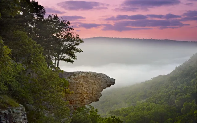
The Hawksbill Crag, also known as Whitaker Point, is located along the northern edge of the Upper Buffalo Wilderness in the Ozark National Forest, just south of the Buffalo National River. It is easily one of the most photograped and recognizable features in Arkansas, and is often seen on publications depicting the outdoors in Arkansas. The hike to it is an easy 3.0 mile round trip, and offers scenic vistas, huge boulders, beautiful waterfalls and colorful wildflowers.
Details
21 Jun 2013 11:43:00
Women wearing flower and sprout-like hairpins walk past an advertisement board in Beijing, China, September 25, 2015. (Photo by Kim Kyung-Hoon/Reuters)

Women wearing flower and sprout-like hairpins walk past an advertisement board in Beijing, China, September 25, 2015. Wearing antenna styled hairpins in the shape of various flowers and plants at scenic spots has become a new trend in Beijing. (Photo by Kim Kyung-Hoon/Reuters)
Details
28 Sep 2015 08:02:00
A student activist is detained during a silent protest after Thailand's election commission filed charges against a group for posting “foul and strong” comments online criticising a military-backed draft constitution, in Bangkok, Thailand April 27, 2016. (Photo by Jorge Silva/Reuters)

A student activist is detained during a silent protest after Thailand's election commission filed charges against a group for posting “foul and strong” comments online criticising a military-backed draft constitution, in Bangkok, Thailand April 27, 2016. (Photo by Jorge Silva/Reuters)
Details
28 Apr 2016 12:39:00
Participants of the Sarenza High Heel Race 2015 warm up prior to the race during a party of the online shoe store, in Paris, Thursday, October 15, 2015. Competitors in teams of three girls race wearing shoes with more than 8 cm-high heels. (Photo by Francois Mori/AP Photo)

Participants of the Sarenza High Heel Race 2015 warm up prior to the race during a party of the online shoe store, in Paris, Thursday, October 15, 2015. Competitors in teams of three girls race wearing shoes with more than 8 cm-high heels. (Photo by Francois Mori/AP Photo)
Details
19 Oct 2015 08:07:00
A truck remains mired in mud and debris on State Route 58 near Tehachapi, California, about 60 miles (97 km) outside of Los Angeles October 17, 2015. (Photo by David McNew/Reuters)

A truck remains mired in mud and debris on State Route 58 near Tehachapi, California, about 60 miles (97 km) outside of Los Angeles October 17, 2015. A mudslide on Thursday left nearly 200 vehicles, including 75 semi-trailer trucks, stuck in up to five feet of mud, local sheriff's spokesman Ray Pruitt said. (Photo by David McNew/Reuters)
Details
21 Oct 2015 08:02:00
A weather vane on a farm building close to the HS2 line on November 24, 2020 in Great Missenden, England. HS2 protesters continue to occupy key infrastructure sites along the proposed HS2 route claiming that the project is “the most carbon-intensive and environmentally destructive project in UK history”. (Photo by Jim Dyson/Getty Images)

A weather vane on a farm building close to the HS2 line on November 24, 2020 in Great Missenden, England. HS2 protesters continue to occupy key infrastructure sites along the proposed HS2 route claiming that the project is “the most carbon-intensive and environmentally destructive project in UK history”. (Photo by Jim Dyson/Getty Images)
Details
23 Dec 2020 00:03:00
Spectators in costume line the race route during the 12th stage of the 109th edition of the Tour de France cycling race, 165,1 km between Briancon and L'Alpe-d'Huez, in the French Alps, on July 14, 2022. (Photo by Marco Bertorello/AFP Photo)

Spectators in costume line the race route during the 12th stage of the 109th edition of the Tour de France cycling race, 165,1 km between Briancon and L'Alpe-d'Huez, in the French Alps, on July 14, 2022. (Photo by Marco Bertorello/AFP Photo)
Details
15 Jul 2022 05:41:00
A rooster is seen with the Zigana Mountain Pass, an important road route connecting the Eastern Black Sea region to Eastern Anatolia at an altitude of 2,050 meters, and the surrounding high areas after effective snowfall has occurred intermittently on October 23, 2024 in Trabzon, Turkiye. (Photo by Hakan Burak Altunoz/Anadolu via Getty Images)

A rooster is seen with the Zigana Mountain Pass, an important road route connecting the Eastern Black Sea region to Eastern Anatolia at an altitude of 2,050 meters, and the surrounding high areas after effective snowfall has occurred intermittently on October 23, 2024 in Trabzon, Turkiye. (Photo by Hakan Burak Altunoz/Anadolu via Getty Images)
Details
19 Mar 2025 03:59:00