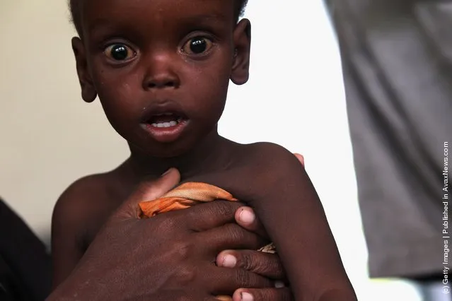
From Britain to China to Mali, new maps showing travel times to the nearest urban centre reveal huge differences between countries. Using Open Street Map and Google, a University of Oxford team have created a visual breakdown that suggests major inequalities when it comes to commuting. Here: China. The dataset used for China was unique as it relied solely on Open Street Map, due to restrictions on accessing Google data. The population is densely concentrated in the east and accessibility is increased, whereas rural provinces in the west remain remote. (Photo by Daniel Weiss/Jennifer Rozier/Malaria Atlas Project/University of Oxford)
Horses are seen before they are evacuated from a ranch as a wildfire is burning along a hillside in Azusa, Calif., Monday, June 20, 2016. New wildfires erupted Monday near Los Angeles and chased people from their suburban homes as an intense heatwave stretching from the West Coast to New Mexico blistered the region. (Photo by Ringo H.W. Chiu/AP Photo)
A man holds a metal bar as a weapon during a training day for former soldiers and volunteers train in a makeshift camp in the outskirts of Port-au-Prince, Haiti, October 28, 2015. Haiti disbanded its abusive armed forces two decades ago but uniformed veterans and young recruits are resurfacing to add another destabilising factor to the volatile Caribbean nation already dealing with a political vacuum. (Photo by Andres Martinez Casares/Reuters)
Canberra resident Bruce Gibbons is seen surrounded by grazing kangaroos as he plays a shot during a session on a practice fairway at Gold Creek Golf Club in Canberra, Australia, May 16, 2017. (Photo by Lukas Coch/Reuters/AAP)
Yuchen Chao of Chinese Taipei in action during the Beach Handball Women's Tournament match between Chinese Taipei and Paraguay at The Beach Handball Arena, Tecnopolis Park, Buenos Aires, Argentina, October 12, 2018. (Photo by Lukas Schulze for OIS/IOC/Handout via Reuters)