Loading...
Done
Women fire fighters directing a hose after the Japanese attack on the US naval base at Pearl Harbour (Pearl Harbor). (Photo by Three Lions/Getty Images)

“Pearl Harbor, known to Hawaiians as Puʻuloa, is a lagoon harbor on the island of Oʻahu, Hawaiʻi, west of Honolulu. Much of the harbor and surrounding lands is a United States Navy deep-water naval base. It is also the headquarters of the U.S. Pacific Fleet. The attack on Pearl Harbor by the Empire of Japan on December 7, 1941, brought the United States into World War II”. – Wikipedia

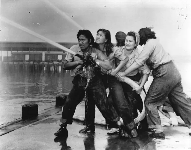
Photo: Women fire fighters directing a hose after the Japanese attack on the US naval base at Pearl Harbour (Pearl Harbor). (Photo by Three Lions)


Details
07 Dec 2012 09:01:00
An old locomotive train that was used for transporting coal is preserved as a monument at Ny-Alesund, in Svalbard, Norway, October 11, 2015. (Photo by Anna Filipova/Reuters)

An old locomotive train that was used for transporting coal is preserved as a monument at Ny-Alesund, in Svalbard, Norway, October 11, 2015. A Norwegian chain of islands just 1,200 km (750 miles) from the North Pole is trying to promote new technologies, tourism and scientific research in a shift from high-polluting coal mining that has been a backbone of the remote economy for decades. (Photo by Anna Filipova/Reuters)
Details
29 Jan 2016 13:19:00
A belly dancer performs in a talent show in early morning ceremonies for Groundhog Day on February 2, 2018 in Punxsutawney, Pa. (Photo by Brett Carlsen/Getty Images)

A belly dancer performs in a talent show in early morning ceremonies for Groundhog Day on February 2, 2018 in Punxsutawney, Pennsylvania. Punxsutawney Phil, the weather-forecasting groundhog, emerged from his burrow in Pennsylvania on Friday, saw his shadow and predicted six more weeks of winter, despite his rival Staten Island Chuck in New York predicting an early spring. (Photo by Brett Carlsen/Getty Images)
Details
03 Feb 2018 07:24:00
In this September 1, 2014 photo released by the U.S. Geological Survey, fluid lava streams from the June 27 lava flow from the Kilauea volcano in Pahoa, Hawaii. The June 27 lava flow is named for the date it began erupting from a new vent. The Hawaiian Volcano Observatory issued a warning Thursday, September 4, 2014 to a rural community in the path of a lava flow on Hawaii's Big Island, as the molten rock moved to within a mile of homes. (Photo by AP Photo/U.S. Geological Survey)

In this September 1, 2014 photo released by the U.S. Geological Survey, fluid lava streams from the June 27 lava flow from the Kilauea volcano in Pahoa, Hawaii. The June 27 lava flow is named for the date it began erupting from a new vent. The Hawaiian Volcano Observatory issued a warning Thursday, September 4, 2014 to a rural community in the path of a lava flow on Hawaii's Big Island, as the molten rock moved to within a mile of homes. Observatory scientists said lava from the Kilauea volcano could reach the Kaohe Homesteads in five to seven days if it continues advancing through cracks in the earth. (Photo by AP Photo/U.S. Geological Survey)
Details
07 Sep 2014 12:47:00
A couple kiss as strong waves hit the coast in Saint-Benoit, on the east of the French Indian Ocean island of La Reunion, on February 2, 2022, ahead of the passage of tropical cyclone Batsirai. La Reunion goes on red alert at 7 pm on February 2, to prepare for the likely passage of cyclone Batsirai overnight. The cyclone already left at least 7,500 homes in nearby Mauritius without power, after it brought heavy downpours and winds of around 120 kilometres per hour, knocking down trees onto electricity lines, according to the local electricity board. (Photo by Richard Bouhet/AFP Photo)

A couple kiss as strong waves hit the coast in Saint-Benoit, on the east of the French Indian Ocean island of La Reunion, on February 2, 2022, ahead of the passage of tropical cyclone Batsirai. La Reunion goes on red alert at 7 pm on February 2, to prepare for the likely passage of cyclone Batsirai overnight. The cyclone already left at least 7,500 homes in nearby Mauritius without power, after it brought heavy downpours and winds of around 120 kilometres per hour, knocking down trees onto electricity lines, according to the local electricity board. (Photo by Richard Bouhet/AFP Photo)
Details
03 Feb 2022 07:38:00
Galapagos – Rocking the Cradle: Four major ocean currents converge along the Galapagos archipelago, creating the conditions for an extraordinary diversity of animal life, April 25, 2016. The islands are home to at least 7,000 flora and fauna species, of which 97 percent of the reptiles, 80 percent of the land birds, 50 percent of the insects and 30 percent of the plants are endemic. The local ecosystem is highly sensitive to the changes in temperature, rainfall and ocean currents that characterize the climatic events known as El Niño and La Niña. These changes cause marked fluctuations in weather and food availability. Many scientists expect the frequency of El Niño and La Niña to increase as a result of climate change, making the Galapagos a possible early-warning location for its effects. (Photo by Thomas P. Peschak for National Geographic/World Press Photo)

Galapagos – Rocking the Cradle: Four major ocean currents converge along the Galapagos archipelago, creating the conditions for an extraordinary diversity of animal life, April 25, 2016. The islands are home to at least 7,000 flora and fauna species, of which 97 percent of the reptiles, 80 percent of the land birds, 50 percent of the insects and 30 percent of the plants are endemic. (Photo by Thomas P. Peschak for National Geographic/World Press Photo)
Details
16 Apr 2018 00:01:00
In this undated handout photo taken by mrwed54, a woman poses for a photo by a lake in the Siberian city of Novosibirsk, about 2,800 kilometers (1,750 miles) east of Moscow, Russia. Thousands of Novosibirsk residents, from scantily clad women to newlyweds have been instagramming selfies near the lake nicknamed the “Siberian Malvides” after the far-flung tropical islands in the Indian Ocean. This is in fact is a man-made dumb of coal from a nearby power station that provides for most of Novosibirsk’s energy needs. Environmentalists are warning people against coming into contact with the water. (Photo by mrwed54 via AP Photo)

In this undated handout photo taken by mrwed54, a woman poses for a photo by a lake in the Siberian city of Novosibirsk, about 2,800 kilometers (1,750 miles) east of Moscow, Russia. Thousands of Novosibirsk residents, from scantily clad women to newlyweds have been instagramming selfies near the lake nicknamed the “Siberian Malvides” after the far-flung tropical islands in the Indian Ocean. This is in fact is a man-made dumb of coal from a nearby power station that provides for most of Novosibirsk’s energy needs. Environmentalists are warning people against coming into contact with the water. (Photo by mrwed54 via AP Photo)
Details
15 Jul 2019 00:07:00
“Lofoten Glow”. I was desperately searching a good sunrise spot this particular morning. Normally Storvatnet Lake is completely covered in snow, so you can only imagine my surprise when I saw these crazy ice formations almost being shot out of the frozen lake. I put my crampons on and took a big risk walking out. Photo location: Storvatnet, Lofoten Islands in Northern Norway. (Photo and caption by Stian Klo/National Geographic Photo Contest)

“Lofoten Glow”. I was desperately searching a good sunrise spot this particular morning. Normally Storvatnet Lake is completely covered in snow, so you can only imagine my surprise when I saw these crazy ice formations almost being shot out of the frozen lake. I put my crampons on and took a big risk walking out. I could hear the ice cracking underneath my feet, and when you’re all alone in a fjord/canyon like this – the cracks are echoed and sound really frightening. Was it worth it? I sure think so! Photo location: Storvatnet, Lofoten Islands in Northern Norway. (Photo and caption by Stian Klo/National Geographic Photo Contest)
Details
08 Apr 2014 09:40:00