Loading...
Done


Cliff Promenade, Netanya

The Cliff Promenade in Netanya is considered to be one of the most beautiful in Israel. It's a nice place for walk, there are marvelous lawns, magnificent observation points, romantic sitting areas in front of the sea, paragliding sites and playgrounds for children. One of the specific features of the promenade, which attracts many people, is mosaic sculpture project "New Wave" created by the sculptor and designer Ruslan Sergeev. At the end of the film you can see The Victory Monument, located next to the promenade.
Details
05 Aug 2014 20:08:00
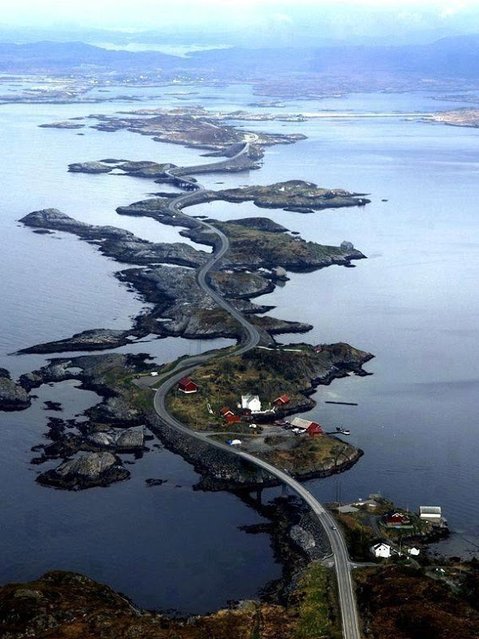
The Atlantic Road, Norway

The Atlantic Ocean Road or the Atlantic Road (Norwegian: Atlanterhavsveien) is a 8.3-kilometer (5.2 mi) long section of County Road 64 that runs through an archipelago in Eide and Averøy in Møre og Romsdal, Norway. It passes by Hustadvika, an unsheltered part of the Norwegian Sea, connecting the island of Averøy with the mainland and Romsdalshalvoya peninsula. It runs between the villages of Karvag on Averoy and Vevang in Eida. It is built on several small islands and skerries, which are connected by several causeways, viaducts and eight bridges – the most prominent being Storseisundet Bridge.
Details
18 Jan 2014 11:42:00
The Crazy Swing At Casa Del Arbol in Ecuador

Located at La Casa Del Arbol or “The Treehouse” in Baños, Ecuador, this small house was built for the stunning view on the Tungurahua Volcano it offers. But the real attraction is the swing attached to one of the tree's branches. It is far from your average swing, and it is surnamed the "Swing at the End of the World" for a good reason. Located off a giant cliff at over 2,600 meters above sea level and with absolutely no safety features, this swing promises a serious thrill to whoever is brave enough to ride it.
Details
10 Mar 2014 13:49:00
Salar de Uyuni

Salar de Uyuni (or Salar de Tunupa) is the world's largest salt flat at 10,582 square kilometers (4,086 sq mi). It is located in the Potosí and Oruro departments in southwest Bolivia, near the crest of the Andes, and is elevated 3,656 meters (11,995 ft) above mean sea level. The Salar was formed as a result of transformations between several prehistoric lakes. It is covered by a few meters of salt crust, which has an extraordinary flatness with the average altitude variations within one meter over the entire area of the Salar.
Details
04 Aug 2012 08:42:00
Kaindy Lake in Kazakhstan

Kaindy Lake (Kazakh: Қайыңды көлі, Qayındı köli) is a 400 metre long lake in Kazakhstan that reaches depths near 30 metres in some areas. It is located 129 km ESE of the city of Almaty and is 2,000 metres above sea level. It was created by the result of an enormous limestone landslide, triggered by the 1911 Kebin earthquake. The track to Kaindy lake has many scenic views to the Saty Gorge, the Chilik River valley and the Kaindy Gorge. Dried-out trunks of submerged Picea schrenkiana trees rise above the surface.
Details
06 Aug 2012 09:58:00
An employee in protective gears sprays disinfectant at the main exhibition tank at the Sea World at Jaya Ancol Dream Park as it is closed for public in the wake of coronavirus outbreak in Jakarta, Indonesia, Saturday, March 14, 2020. Indonesia's capital city announced a lockdown of all tourist destinations and entertainment spots as well as the closing all of its public schools for the next 14 days amid the global outbreak. For most people, the new coronavirus causes only mild or moderate symptoms. For some it can cause more severe illness. (Photo by Dita Alangkara/AP Photo)

An employee in protective gears sprays disinfectant at the main exhibition tank at the Sea World at Jaya Ancol Dream Park as it is closed for public in the wake of coronavirus outbreak in Jakarta, Indonesia, Saturday, March 14, 2020. Indonesia's capital city announced a lockdown of all tourist destinations and entertainment spots as well as the closing all of its public schools for the next 14 days amid the global outbreak. For most people, the new coronavirus causes only mild or moderate symptoms. For some it can cause more severe illness. (Photo by Dita Alangkara/AP Photo)
Details
18 Apr 2020 00:01:00
A sailor of the Marshal Shaposhnikov anti-submarine destroyer takes part in the “Vostok-2022” military exercises at the Peter the Great Gulf of the Sea of Japan outside the city of Vladivostok on September 5, 2022. The Vostok 2022 military exercises, involving several Kremlin-friendly countries including China, takes place from September 1-7 across several training grounds in Russia's Far East and in the waters off it. Over 50,000 soldiers and more than 5,000 units of military equipment, including 140 aircraft and 60 ships, are involved in the drills. (Photo by Kirill Kudryavtsev/AFP Photo)

A sailor of the Marshal Shaposhnikov anti-submarine destroyer takes part in the “Vostok-2022” military exercises at the Peter the Great Gulf of the Sea of Japan outside the city of Vladivostok on September 5, 2022. The Vostok 2022 military exercises, involving several Kremlin-friendly countries including China, takes place from September 1-7 across several training grounds in Russia's Far East and in the waters off it. Over 50,000 soldiers and more than 5,000 units of military equipment, including 140 aircraft and 60 ships, are involved in the drills. (Photo by Kirill Kudryavtsev/AFP Photo)
Details
16 Sep 2022 05:09:00
People struggle with the wind as they cross the street under the rain as typhoon Mitag is expected to hit northern Taiwan, in Keelung, Taiwan, 30 September 2019. According to report, Typhoon Mitag will disrupt air, land and water traffic. Mitag is located at sea about 290 kilometers off the south-southeast of Yilan County, moving at 27 kilometers per hour at a northwesterly direction, with maximum sustained winds of 126 kilometers per hour, with gusts of up to 162 kilometers per hour, and with a radius of 180 kilometers, according to Taiwan Central Weather Bureau. (Photo by Ritchie B. Tongo/EPA/EFE/Rex Features/Shutterstock)

People struggle with the wind as they cross the street under the rain as typhoon Mitag is expected to hit northern Taiwan, in Keelung, Taiwan, 30 September 2019. According to report, Typhoon Mitag will disrupt air, land and water traffic. Mitag is located at sea about 290 kilometers off the south-southeast of Yilan County, moving at 27 kilometers per hour at a northwesterly direction, with maximum sustained winds of 126 kilometers per hour, with gusts of up to 162 kilometers per hour, and with a radius of 180 kilometers, according to Taiwan Central Weather Bureau. (Photo by Ritchie B. Tongo/EPA/EFE/Rex Features/Shutterstock)
Details
02 Oct 2019 00:05:00