Loading...
Done
Natural gas plant in Pittsburg, CA (detail of Power Landscape), 2013. (Photo by Jenny Odell)

Jenny Odell repurposes online imagery mostly from Google Maps, but also from YouTube, Craigslist, and other sites. In her “Satellite Collections”, for example, she incorporated aerial views of swimming pools, basketball courts, parking lots, and other recognizable structures, seen from space. Her more recent series, “Satellite Landscapes”, includes painstakingly isolated Google Maps imagery of oil refineries, wastewater treatment plants, solar farms, etc. This work is meant as a reminder of our physically determined and vulnerable existence, since we depend on many of these things for survival and maintenance of our way of life. Photo: Natural gas plant in Pittsburg, CA (detail of Power Landscape), 2013. (Photo by Jenny Odell)
Details
19 Mar 2014 07:28:00
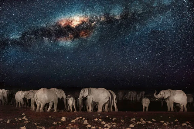
This watering hole is the social hub of the veldt; the scrubby grasslands that stretch across Namibia. The scorched earth supports sometimes fragile populations of magnificent wildlife – from endangered predators to plentiful herds of game. But these gentle giraffes and elephants need to be careful: lions don’t sleep at night, they hunt! The spectacular starscape above southern Africa is unchanged since explorers first mapped the continent. The photographer, Pietro Olivetta from Italy, said he had to be patient to capture these shots – but it was worth the wait. (Photo by Pietro Olivetta/Caters News)

This watering hole is the social hub of the veldt; the scrubby grasslands that stretch across Namibia. The scorched earth supports sometimes fragile populations of magnificent wildlife – from endangered predators to plentiful herds of game. But these gentle giraffes and elephants need to be careful: lions don’t sleep at night, they hunt! The spectacular starscape above southern Africa is unchanged since explorers first mapped the continent. The photographer, Pietro Olivetta from Italy, said he had to be patient to capture these shots – but it was worth the wait. (Photo by Pietro Olivetta/Caters News)
Details
20 Feb 2017 00:05:00
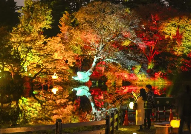
A couple enjoys viewing illuminated autumn leaves with projection mapping at Shinjuku Gyoen National Garden during a preview at the garden in Tokyo, Japan on November 22, 2023. The illumination will start on 22 November through 03 December 2023. (Photo by Kimimasa Mayama/EPA/EFE)

A couple enjoys viewing illuminated autumn leaves with projection mapping at Shinjuku Gyoen National Garden during a preview at the garden in Tokyo, Japan on November 22, 2023. The illumination will start on 22 November through 03 December 2023. (Photo by Kimimasa Mayama/EPA/EFE)
Details
29 Nov 2023 00:10:00
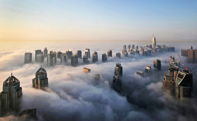
In this Monday, October 5, 2015 photo, a thick blanket of early morning fog partially shrouds the skyscrapers of the Marina and Jumeirah Lake Towers districts of Dubai, United Arab Emirates. Dubai's rapid transformation from a desert outpost into one of the world's most architecturally stunning cities is mapped out in the Marina. Where just 15 years ago there was empty, flat land, today a bustling neighborhood thrives centered around a canal and an impressive skyline that pierces through the clouds. (Photo by Kamran Jebreili/AP Photo)

In this Monday, October 5, 2015 photo, a thick blanket of early morning fog partially shrouds the skyscrapers of the Marina and Jumeirah Lake Towers districts of Dubai, United Arab Emirates. Dubai's rapid transformation from a desert outpost into one of the world's most architecturally stunning cities is mapped out in the Marina. Where just 15 years ago there was empty, flat land, today a bustling neighborhood thrives centered around a canal and an impressive skyline that pierces through the clouds. (Photo by Kamran Jebreili/AP Photo)
Details
10 Dec 2015 08:03:00
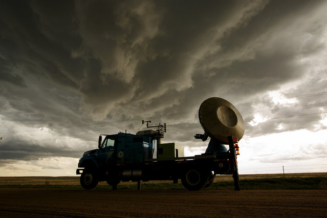
The Doppler on Wheels (DOW) vehicle scans a supercell thunderstorm during a tornado research mission, May 8, 2017 in Elbert County near Agate, Colorado. Doppler on Wheels (DOW) is a mobile doppler radar mounted on a truck that brings instruments directly into storms, allowing scientists to scan storms and tornadoes and make 3-D maps of wind and debris. (Photo by Drew Angerer/Getty Images)

The Doppler on Wheels (DOW) vehicle scans a supercell thunderstorm during a tornado research mission, May 8, 2017 in Elbert County near Agate, Colorado. Doppler on Wheels (DOW) is a mobile doppler radar mounted on a truck that brings instruments directly into storms, allowing scientists to scan storms and tornadoes and make 3-D maps of wind and debris. (Photo by Drew Angerer/Getty Images)
Details
18 May 2017 08:54:00
Plus Fours Routefinder - Worlds First Navigation System

Invented in 1920′s this could be world’s first navigation system. No satellites or digital screens were used in the making of this portable navigation system. Called Plus Fours Routefinder, this little invention was designed to be worn on your wrist, and the “maps” were printed on little wooden rollers which you would turn manually as you drove along.
Details
19 Mar 2014 15:14:00
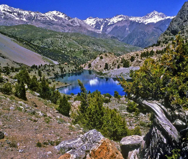
Fann Mountains In Tajikistan

Fann Mountains are part of the western Pamir-Alay mountain system and are located in Tajikistan's Sughd Province between the Zarafshan Range to the north and the Gissar Range to the south (see map of Fann Mountains). In the east-west direction they extend from Fandarya River to Archimaydan River, and the cluster of Marguzor lakes west of Archimaydan is also included in the Fanns.
Details
29 May 2013 11:45:00
Bagt Kosgi Ashgabat - Turkmenistan

The "Wedding Palace" (Bagt Kosgi) is located in the southwest of Ashgabat. while the building was designed in a sphere shape surrounded by the eight-corner "Oguzkhan Star" on the corners of the building. There is a map of Turkmenistan on the outer space of the sphere whose radius is 32 meters and it can be seen from far away as the sun reflects off it.
Details
18 May 2014 16:37:00