Loading...
Done
The beautiful image captured by Steve Lance Lee of the Milky Way seemingly errupting from Mt. Fuji in Japan. (Photo by Steve Lance Lee/Caters News)

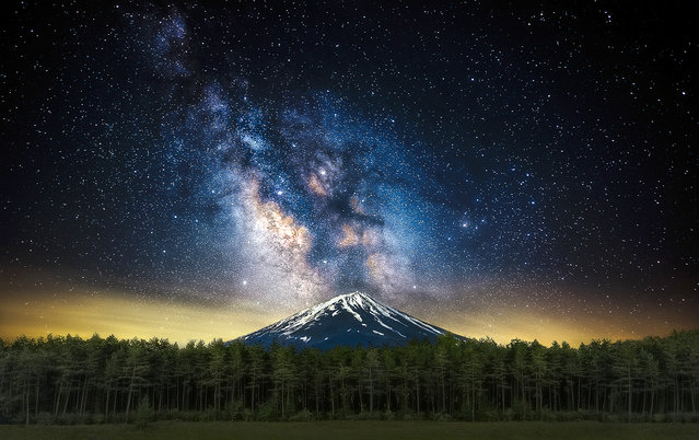
This is the mesmerising image of a colourful Milky Way shining down on Mount Fuji. Steve Lance Lee, 37, captured the sky above the iconic mountain whilst on his honey moon in Lake Kawaguchiko, Japan. Mount Fuji is illuminated underneath the galaxy of stars, creating an impressive landscape. Here: The beautiful image captured by Steve Lance Lee of the Milky Way seemingly errupting from Mt. Fuji in Japan. (Photo by Steve Lance Lee/Caters News)
Details
14 Oct 2017 09:29:00
Mount Roraima

Mount Roraima (Spanish: Monte Roraima, also known as Tepuy Roraima and Cerro Roraima; Portuguese: Monte Roraima [ˈmõtʃi ʁoˈɾajmɐ]) is the highest of the Pakaraima chain of tepui plateau in South America. First described by the English explorer Sir Walter Raleigh in 1596, its 31 km2 summit area is defended by 400-metre-tall cliffs on all sides. The mountain includes the triple border point of Venezuela, Brazil and Guyana.
Details
11 Sep 2012 08:04:00
Kawachi Fuji Garden In Japan

Wisteria Tunnel is located at the Kawachi Fuji Gardens in Kitakyushu, Japan. Flowering wisteria blooms hang to create rows bursting with color overhead and dappled shadows below.
Details
21 Jan 2013 12:52:00
A women rides a motor bike on a street covered with volcanic ash from an eruption of Mount Kelud, in Solo, Indonesia, Friday, February 14, 2014. A major volcanic eruption in Indonesia blasted clouds of ash and debris 18 kilometers (12 miles) into the air on Friday, forcing authorities to close six airports, cancel flights elsewhere in Southeast Asia and evacuate more than 100,000 people from the mountain. (Photo by Hafidz Novalsyah/AP Photo)

A women rides a motor bike on a street covered with volcanic ash from an eruption of Mount Kelud, in Solo, Indonesia, Friday, February 14, 2014. A major volcanic eruption in Indonesia blasted clouds of ash and debris 18 kilometers (12 miles) into the air on Friday, forcing authorities to close six airports, cancel flights elsewhere in Southeast Asia and evacuate more than 100,000 people from the mountain. (Photo by Hafidz Novalsyah/AP Photo)
Details
15 Feb 2014 07:38:00
Mount Agung's eruption is seen next to a Balinese temple at Kubu sub-district in Karangasem Regency on Indonesia's resort island of Bali on November 26, 2017. (Photo by Sonny Tumbelaka/AFP Photo)

Mount Agung's eruption is seen next to a Balinese temple at Kubu sub-district in Karangasem Regency on Indonesia's resort island of Bali on November 26, 2017. Indonesia authorities raised the alert for the rumbling volcano to highest level on Monday and closed the international airport on tourist island of Bali stranding thousands of travelers. (Photo by Sonny Tumbelaka/AFP Photo)
Details
28 Nov 2017 08:37:00
A villager watches as Mount Sinabung volcano erupts, in Kuta Tengah village, Karo Regency in Indonesia's North Sumatra April 1, 2015. The Indonesian volcano was dormant for 400 years before erupting in 2010. (Photo by Y. T. Haryono/Reuters)

A villager watches as Mount Sinabung volcano erupts, in Kuta Tengah village, Karo Regency in Indonesia's North Sumatra April 1, 2015. The Indonesian volcano was dormant for 400 years before erupting in 2010. (Photo by Y. T. Haryono/Reuters)
Details
02 Apr 2015 13:00:00
In this Tuesday, March 10, 2015 photo, rime ice covers rocks on the summit of Mount Washington in New Hampshire. Rime ice occurs when freezing fog hits stationary objects in frigid conditions. (Photo by Robert F. Bukaty/AP Photo)

In this Tuesday, March 10, 2015 photo, rime ice covers rocks on the summit of Mount Washington in New Hampshire. Rime ice occurs when freezing fog hits stationary objects in frigid conditions. (Photo by Robert F. Bukaty/AP Photo)
Details
17 Mar 2015 12:54:00
On the western side of Mount Hood lies the longest glacier cave system in the contiguous United States. In 2012, these caves were mapped to a combined length of 7,166.8 feet by cave explorers Brent McGregor and Eddy Cartaya. Currently, the total passage length is hundreds of feet less. Glaciers are frozen rivers; they are always moving and changing. In the past five years, we have seen the caves melt, shrink and collapse in a dramatic way. The caves are formed by water carving away at the ice. (Photo and caption by Josh Hydeman)

On the western side of Mount Hood lies the longest glacier cave system in the contiguous United States. In 2012, these caves were mapped to a combined length of 7,166.8 feet by cave explorers Brent McGregor and Eddy Cartaya. Currently, the total passage length is hundreds of feet less. Glaciers are frozen rivers; they are always moving and changing... (Photo and caption by Josh Hydeman)
Details
22 Mar 2015 11:05:00