Loading...
Done
 Flying Squirrel

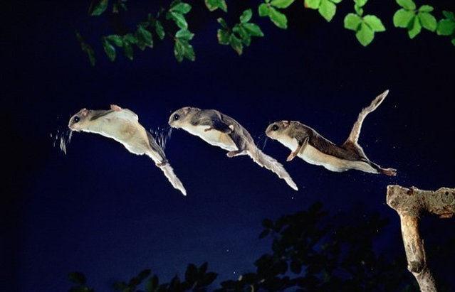
Flying squirrels are not capable of powered flight like birds or bats; instead, they glide between trees. They are capable of obtaining lift within the course of these flights, with flights recorded to 90 meters (295 ft). The direction and speed of the animal in midair is varied by changing the positions of its two arms and legs, largely controlled by small cartilaginous wrist bones. This changes the tautness of the patagium, a furry parachute-like membrane that stretches from wrist to ankle. It has a fluffy tail that stabilizes in flight. The tail acts as an adjunct airfoil, working as an air brake before landing on a tree trunk.
Details
07 Aug 2012 16:29:00
Salar de Uyuni

Salar de Uyuni (or Salar de Tunupa) is the world's largest salt flat at 10,582 square kilometers (4,086 sq mi). It is located in the Potosí and Oruro departments in southwest Bolivia, near the crest of the Andes, and is elevated 3,656 meters (11,995 ft) above mean sea level. The Salar was formed as a result of transformations between several prehistoric lakes. It is covered by a few meters of salt crust, which has an extraordinary flatness with the average altitude variations within one meter over the entire area of the Salar.
Details
04 Aug 2012 08:42:00
Pretarsus of the third leg of a female drone fly (Eristalis tenax), ventral view, by Dr. Jan Michels, Institute of Zoology, Christian-Albrechts-University of Kiel, Germany. (Photo by Olympus BioScapes)

“Microscope images forge an extraordinary bond between science and art, said Hidenao Tsuchiya, Olympus America's Vice President and General Manager for the Scientific Equipment Group. We founded this competition to focus on the fascinating stories coming out of today's life science research laboratories. The thousands of images that people have shared with the competition over the years reflect some of the most exciting work going on in research today – work that can help shed light on the living universe and ultimately save lives. We look at BioScapes and these beautiful images as sources of education and inspiration to us and the world”. – OlympusBioScapes

Photo: Pretarsus of the third leg of a female drone fly (Eristalis tenax), ventral view, by Dr. Jan Michels, Institute of Zoology, Christian-Albrechts-University of Kiel, Germany. (Photo by Olympus BioScapes)
Details
29 Jul 2012 09:20:00
Antelope Canyon Arizona USA

Antelope Canyon is the most-visited and most-photographed slot canyon in the American Southwest. It is located on Navajo land near Page, Arizona. Antelope Canyon includes two separate, photogenic slot canyon sections, referred to individually as Upper Antelope Canyon or The Crack; and Lower Antelope Canyon or The Corkscrew.
Details
28 Jul 2012 14:41:00
Thor's Well in Cape Perpetua

For at least 6,000 years Native Americans hunted for mussels, crabs, sea urchins, and clams along the coast near Cape Perpetua. Evidence of their lives can still be found in the huge piles of discarded mussel shells that lie along the shore near the Cape Perpetua Visitor Center
Details
22 Jul 2012 20:13:00
dried riverbed

Bernard on Journey, Rest, and Peace
Details
17 Jul 2012 12:01:00
The Big Cloud: The Lovely Monster by Camille Seaman

“Award-winning photographer Camille Seaman, best known for her earlier work depicting massive polar icebergs, recently turned her lens on another incredible natural phenomenon - storm clouds above the American Midwest. She partnered with experienced storm chasers and began to stalk a particular type of storm cloud – the supercell. On June 22, 2012, in western Nebraska, she encountered an enormous supercell and captured its many faces”. (Photo by Camille Seaman via TheAtlantic)
Details
17 Jul 2012 07:26:00
Underground River

The Puerto Princesa Subterranean River National Park is located about 50 kilometres (30 mi) north of the city centre of Puerto Princesa, Palawan, Philippines. The river is also called Puerto Princesa Underground River. The national park is located in the Saint Paul Mountain Range on the northern coast of the island. It is bordered by St. Paul Bay to the north and the Babuyan River to the east. The City Government of Puerto Princesa has managed the National Park since 1992. The park is also known as St. Paul's Subterranean River National Park, or St. Paul Underground River. The entrance to the Subterranean River is a short hike from the town of Sabang.
Details
16 Jul 2012 11:37:00