Loading...
Done
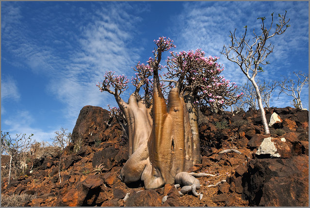
The Wonder Land of Socotra, Yemen

The largest island, also called Socotra, is about 95% of the landmass of the archipelago. It lies some 240 kilometres (150 mi) east of the Horn of Africa and 380 kilometres (240 mi) south of the Arabian Peninsula. The island is very isolated and through the process of speciation, a third of its plant life is found nowhere else on the planet. It has been described as the most alien-looking place on Earth. The island measures 132 kilometres (82 mi) in length and 49.7 kilometres (30.9 mi) in width.
Details
25 Sep 2013 09:11:00
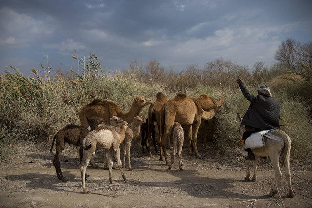
In this Sunday, February 18, 2018 photo, Palestinian camel herder Salem Rashaideh, leads the way for the camels in the territory of Israeli Kibbutz Kalya, near the Dead Sea in the West Bank. (Phoro by Oded Balilty/AP Photo)

In this Sunday, February 18, 2018 photo, Palestinian camel herder Salem Rashaideh, leads the way for the camels in the territory of Israeli Kibbutz Kalya, near the Dead Sea in the West Bank. For three months a year, in the winter time Bedouin Arab herders take their 130 camels to graze on the shores of the Dead Sea, at the lowest place on Earth. (Phoro by Oded Balilty/AP Photo)
Details
19 Mar 2018 00:03:00
Beltane Fire Society performers celebrate the coming of summer by participating in the Beltane Fire Festival on Calton Hill April 30, 2019 in Edinburgh, Scotland. (Photo by Jeff J. Mitchell/Getty Images)

Beltane Fire Society performers celebrate the coming of summer by participating in the Beltane Fire Festival on Calton Hill April 30, 2019 in Edinburgh, Scotland. The event celebrates the ending of winter and is a revival of the ancient Celtic and Pagan festival of Beltane, the Gaelic name for the month of May. This years festival was highlighting climate change, with the central character The May Queen being seen to express her rage at the damage done to Earth. (Photo by Jeff J. Mitchell/Getty Images)
Details
03 May 2019 00:03:00
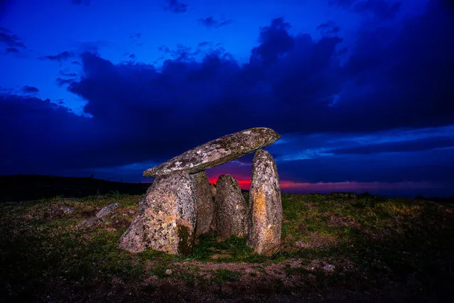
Serra da Aboboreira Megalithic Set (Meninas do Crasto) on September 24, 2023 in Baiao, Portugal. Since 1978 that Serra da Aboboreira (Aboboreira Mountains) has been the scene of a systematic study of its archeological values, among which are the monuments known as megalithic. These are funerary monuments designing the landscape. These dolmens were constructed with stones (lithos) of medium or large dimensions (mega), which were laid in a, more or less, vertical position. Over these, it was still placed a lid, also of stone. These containers were covered by an artificial mound of earth and stones (dolmen). (Photo by Octavio Passos/Getty Images)

Serra da Aboboreira Megalithic Set (Meninas do Crasto) on September 24, 2023 in Baiao, Portugal. Since 1978 that Serra da Aboboreira (Aboboreira Mountains) has been the scene of a systematic study of its archeological values, among which are the monuments known as megalithic. These are funerary monuments designing the landscape. These dolmens were constructed with stones (lithos) of medium or large dimensions (mega), which were laid in a, more or less, vertical position. Over these, it was still placed a lid, also of stone. These containers were covered by an artificial mound of earth and stones (dolmen). (Photo by Octavio Passos/Getty Images)
Details
28 Dec 2023 21:07:00
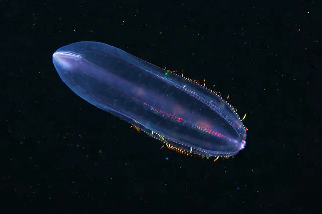
A Comb jelly – Beroe cucumis. (Photo by Alexander Semenovs/Caters News)

Underwater photographer Alexander Semenovs has snapped some of the most stunning, fragile life forms anywhere on planet Earth. Shot in deep, dark conditions, the images continue to provide an insight into what lies beneath, with glowing creatures appearing a lot like aliens in the pitch-black water. Semenovs has shot the likes of bioluminescent jellyfish, aggressive-looking worms and many species that leave a lot to the imagination. The 30-year-old from Moscow does the majority of his work in the White Sea, near the Arctic Circle. Here: A Comb jelly – Beroe cucumis. (Photo by Alexander Semenovs/Caters News)
Details
23 Nov 2015 08:06:00
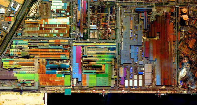
Industrial Sector, Tokai, Japan. (Photo by Benjamin Grant/Digital Globe/Caters News)

This series of pictures shot by satellite, show the man-made world as astronauts see it. Artist Benjamin Grant uses Google Earth to find the most compelling satellite images of human civilization. The stunning pictures of sprawling metropolises and vast reservoirs are sometimes unidentifiable until zoomed in. In order to find an extraordinary picture in the practically endless supply of satellite data, Benjamin focuses on the themes of current events or environmental issues. Here: Industrial Sector, Tokai, Japan. (Photo by Benjamin Grant/Digital Globe/Caters News)
Details
04 Feb 2015 12:21:00
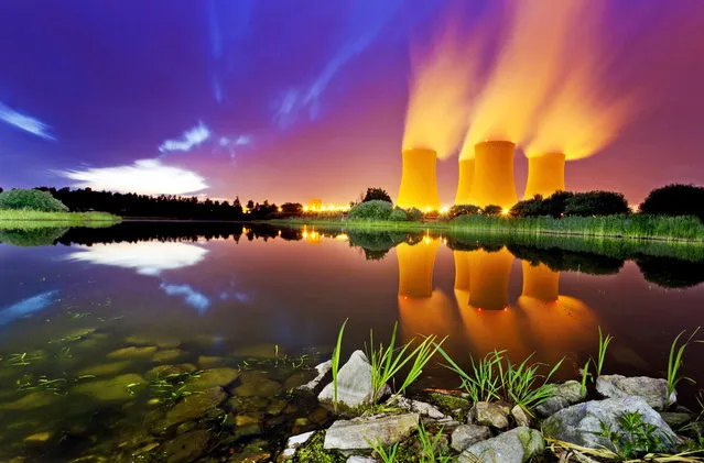
Nuclear power station Temelin, Czech Republic. (Photo by Radek Kalhous/Caters News)

“You wouldn’t normally associate power stations with beautiful scenic shots but one photographer has traveled nearly 2000 to track down the ugliest energy plants and show them in a whole new light. Czech snapper, Radek Kalhous, uses Google Earth to find the perfect locations for his unique pictures and arrives at each site after sunset to create the atmospheric shots”. – Caters News. Photo: Nuclear power station Temelin, Czech Republic. (Photo by Radek Kalhous/Caters News)
Details
27 Jul 2014 11:30:00
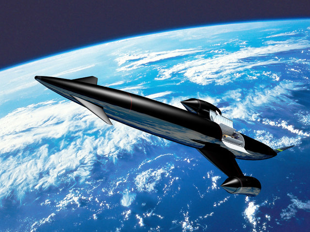
Artist's impression of Skylon. (Photo by Reaction Engines Ltd)

“A small British company with a dream of building a re-usable space plane has won an important endorsement from the European Space Agency (ESA) after completing key tests on its novel engine technology. Reaction Engines Ltd believes its Sabre engine, which would operate like a jet engine in the atmosphere and a rocket in space, could displace rockets for space access and transform air travel by bringing any destination on Earth to no more than four hours away”. – Chris Wickham via Reuters. Photo: Artist's impression of Skylon. (Photo by Reaction Engines Ltd)
Details
29 Nov 2012 10:31:00