Loading...
Done
Hikers walk to reach the top of Naqba Rum area in South Sinai, Egypt, November 20, 2015. (Photo by Asmaa Waguih/Reuters)

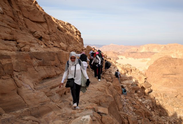
Hikers walk to reach the top of Naqba Rum area in South Sinai, Egypt, November 20, 2015. Bedouins in the "Sinai is Safe" group guided more than 100 hikers over a 25 km (15 mile) trek over the trails of the White Canyon and the Closed Canyon. The NGO aims to challenge mainstream perceptions of the area by encouraging Nile Valley residents to explore the untamed wilderness with the Bedouin tribes. (Photo by Asmaa Waguih/Reuters)
Details
03 Dec 2015 08:00:00
Fine Horses And Fierce Eagles Are The wings Of The Kazakh

The Kazakhs are the descendants of Turkic, Mongolic and Indo-Iranian tribes and Huns that populated the territory between Siberia and the Black Sea. They are a semi-nomadic people and have roamed the mountains and valleys of western Mongolia with their herds since the 19th century. The ancient art of eagle hunting is one of many traditions and skills that the Kazakhs have, in recent decades, been able to hold on to. They rely on their clan and herds, believing in pre-Islamic cults of the sky, the ancestors, fire and the supernatural forces of good and evil spirits.
Details
20 Feb 2014 12:12:00
The Majesty Of Norway's Dalsnibba Mountain

Dalsnibba is a mountain in Stranda Municipality in More og Romsdal county, Norway. It is located at the end of the Geiranger valley, about 21 kilometres (13 mi) south of the village of Geiranger and the Geirangerfjorden. The 2-square-kilometre (0.77 sq mi) lake Djupvatnet lies directly to the southeast of the mountain. The mountain is located very near the county border with both Oppland and Sogn og Fjordane counties, in the southeastern part of Møre og Romsdal county.
Details
24 Jul 2013 10:28:00
In this composite image (top) flooding is seen in the Toowoomba central business district on  January 10, 2011 and (bottom) the same location as seen on January 5, 2012 in Toowoomba, Australia

In this composite image (top) flooding is seen in the Toowoomba central business district on January 10, 2011 and (bottom) the same location as seen on January 5, 2012 in Toowoomba, Australia. January 10 marks the one year anniversary of the inland tsunami that devestated southern Queensland's Lockyer valley killing 23 people. (Photos by Dan Proud (top) and Lisa Maree Williams (bottom) /Getty Images)
Details
06 Jan 2012 13:10:00
Haley nears the top of the tree. (Photo by Steven Pearce/The Tree Projects/The Guardian)

The Tree Projects team spent 67 days documenting one eucalyptus regnans in the Styx valley of Tasmania. Using a combination of tree-climbing and elaborate arboreal rigging techniques, they produced an intimate portrait from an impossible perspective of one of the world’s largest individual flowering trees, which goes by several common names. These photos document the process that resulted in an extraordinary ultra high-definition photograph. Here: Haley nears the top of the tree. (Photo by Steven Pearce/The Tree Projects/The Guardian)
Details
01 Feb 2017 06:37:00
Photographers: Joel Robison Part3

“Hi! I'm Joel, I live in a valley in British Columbia's Rocky Mountains, as close to the forest as I could possibly be! I love to run, bike, jump, eat and create and I hope that you enjoy my work as much as I enjoy creating it!” – Joel Robison. (Photo by: Joel Robison; Source: Flickr)


See Also:Photographers: Joel Robison Part1
Details
02 Nov 2013 09:03:00
Local residents evacuate onto a street minutes after an earthquake in central Kathmandu, Nepal, May 12, 2015. (Photo by Athit Perawongmetha/Reuters)

Local residents evacuate onto a street minutes after an earthquake in central Kathmandu, Nepal, May 12, 2015. A 7.3 magnitude earthquake killed at least 37 people and spread panic in Nepal on Tuesday, bringing down buildings already weakened by a devastating tremor less than three weeks ago and unleashing landslides in Himalayan valleys near Mount Everest. The earthquake was centered 76 km (47 miles) east of the capital in a hilly area close to the border with Tibet, according to coordinates provided by the U.S. Geological Survey. (Photo by Athit Perawongmetha/Reuters)
Details
13 May 2015 11:36:00
Lake Assal Crater Lake In The Central Djibouti

Lake Assal is a crater lake in central-western Djibouti. It is located at the western end of Gulf of Tadjoura in the Tadjoura Region, touching Dikhil Region, at the top of the Great Rift Valley, some 120 km (75 mi) west of Djibouti city. Lake Assal is a saline lake which lies 155 m (509 ft) below sea level in the Afar Triangle, making it the lowest point on land in Africa and the third-lowest land depression on Earth after the Dead Sea and Sea of Galilee.
Details
15 Jul 2015 10:19:00