Loading...
Done
Parkour In Motion By Ben Franke

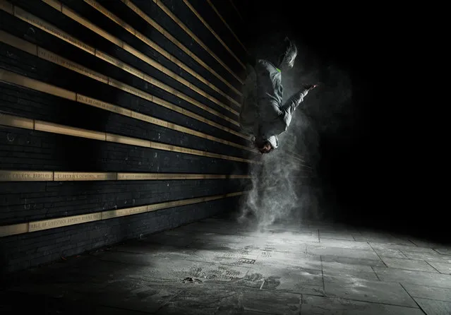
New York-based photographer and videographer Ben Franke captures the beautiful, acrobatic movement of parkour. The photographer followed New York City free runners, known as tracers, for a few years, documenting their athletic prowess as they freely roamed about the urban streets with a zest for life. Finally, he decided to take his personal project to the next level by producing a collection of dramatically captivating portraits of these athletes for his series titled Parkour Motion.
Details
07 Feb 2013 12:19:00
Whimsical Sky Art by Thomas Lamadieu

French artist Thomas Lamadieu, also know as Roots Art, must really love looking at the sky. Every time he looks up, Thomas sees a potential canvas where the building rooftops frame the sky. He photographs it and uses the odd sky shapes to create whimsical line drawings. “My artistic aim is to show a different perception of urban architecture and the everyday environment around us, what we can construct with a boundless imagination,” says Thomas. (Photo by Thomas Lamadieu)
Details
22 Apr 2013 05:17:00
“Potholes” Project by Photographer Davide Luciano

“Potholes” is a series of photographs depicting the concave street cracks and holes as a collection of imaginative tableaux in the city. Captured within the backdrops of New York City, Los Angeles, Toronto and Montreal, the sets explore the urban flaws as a playground creating a multitude of uses out of the potholes. Directly engaging the street and the city, the highly imaginative series transforms the bad into good, creating a tongue-in-cheek collection that is at once contextual and surreal”. (Photo and caption by Davide Luciano)
Details
03 Dec 2013 06:15:00
Redesigning Old Military Airplanes

A cemetery of disused war planes in the scorching Arizona desert has been given a new lease of life – as part of an art project.
“The Boneyard Project” resurrects disused warplanes that lie in the famous Boneyard in Arizona by letting graffiti artists paint them.
More than 30 of the world’s best urban artists worked on five ruined US Air Force jets, vividly bringing them back to life with paint and colour.
Details
19 Dec 2012 12:39:00
A woman wears roller skates with lights on the bottom at Rich City Skate in Richton Park, Illinois, January 12, 2015. (Photo by Jim Young/Reuters)

A woman wears roller skates with lights on the bottom at Rich City Skate in Richton Park, Illinois, January 12, 2015. A handful of decades-old skating venues put Chicago at the center of a vibrant African-American subculture of urban roller skate dancing that stretches from Atlanta to Detroit and from Los Angeles to New York. While mainstream roller skating has been on a long decline, a new generation of skaters travel a circuit of rinks around the country to compete and show off their moves. (Photo by Jim Young/Reuters)
Details
05 Feb 2015 13:00:00
Abandoned Villa. (Photo by Gaz Mather/Cater News)

“A British photographer has captured incredible images of Italys most beautiful derelict buildings – by sneaking into abandoned structures. The stunning shots of hospitals, churchs and deserted buildings show abandoned beds, overgrown arches and staggering staircases. Gaz Mather, 40, is a dedicated urban explorer who takes stunning photographs of deserted buildings – documenting their haunting decay. Gaz from Manchester spent a long weekend touring deserted buildings in the Northern region of Italy”. – Caters News. Photo: Abandoned Villa. (Photo by Gaz Mather/Cater News)
Details
06 May 2014 10:18:00
From Britain to China to Mali, new maps showing travel times to the nearest urban centre reveal huge differences between countries. Using Open Street Map and Google, a University of Oxford team have created a visual breakdown that suggests major inequalities when it comes to commuting. Here: China. The dataset used for China was unique as it relied solely on Open Street Map, due to restrictions on accessing Google data. The population is densely concentrated in the east and accessibility is increased, whereas rural provinces in the west remain remote. (Photo by Daniel Weiss/Jennifer Rozier/Malaria Atlas Project/University of Oxford )

From Britain to China to Mali, new maps showing travel times to the nearest urban centre reveal huge differences between countries. Using Open Street Map and Google, a University of Oxford team have created a visual breakdown that suggests major inequalities when it comes to commuting. Here: China. The dataset used for China was unique as it relied solely on Open Street Map, due to restrictions on accessing Google data. The population is densely concentrated in the east and accessibility is increased, whereas rural provinces in the west remain remote. (Photo by Daniel Weiss/Jennifer Rozier/Malaria Atlas Project/University of Oxford)
Details
12 Jan 2018 06:43:00
Corinth Canal

The Corinth Canal is a canal that connects the Gulf of Corinth with the Saronic Gulf in the Aegean Sea. It cuts through the narrow Isthmus of Corinth and separates the Peloponnesian peninsula from the Greek mainland, thus effectively making the former an island. The builders dug the canal through the Isthmus at sea level; no locks are employed. It is 6.4 kilometres (4.0 mi) in length and only 21.3 metres (70 ft) wide at its base, making it unpassable for most modern ships. It now has little economic importance.

Details
12 Mar 2013 12:21:00