Loading...
Done


“Dover Castle is a medieval castle in the town of the same name in the English county of Kent. It was founded in the 12th century and has been described as the “Key to England” due to its defensive significance throughout history. It is the largest castle in England.

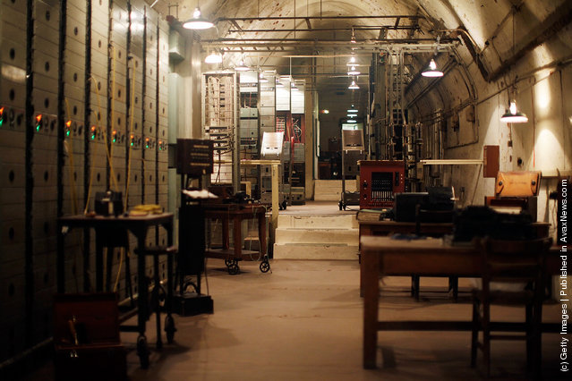
The outbreak of the Second World War in 1939 saw the tunnels converted first into an air-raid shelter and then later into a military command centre and underground hospital. In May 1940, Admiral Sir Bertram Ramsey directed the evacuation of French and British soldiers from Dunkirk, code-named Operation Dynamo, from his headquarters in the cliff tunnels”. – Wikipedia

Photo: The Repeater Station in the subterranean tunnels underneath Dover Castle, which has been restored by English Heritage for a public exhibition on June 3, 2011 in Dover, England. The evacuation of allied soldiers from Dunkirk was masterminded and co-ordinated from the secret command and control centre in the tunnels deep below the castle. (Photo by Matthew Lloyd/Getty Images)
Details
07 Jun 2011 09:26:00
Lumberjacks From California

Dramatic photos show the measure of a man in contrast to the enormity of nature.
A series of photos from the Humboldt State University Library capture lumberjacks working among the redwoods in Humboldt County, California.
The photos are part of the Ericson Collection....


SEE ALSO: «Huge Plants» AND «Loggers»

Details
09 Oct 2012 05:57:00


Eight-year-old handicapped Chinese girl Qian Hongyan crawls with two home-made props and part of a basketball at Zhuangxia Village on January 5, 2005 in Luliang County of Qujing City, Yunnan Province, China. The girl who lost both of her legs in a traffic accident in 2000 at the age of three, struggles to live her life with a basketball as an underprop, “walking” between school and home by herself. The girl's story is widely reported in the country, and experts from China Rehabilitation Research Center has come to Qian's home to help her for rehabilitative treatment early 2005. (Photo by China Photos/Getty Images)
Details
29 Jun 2011 11:33:00
Detian Waterfall - China

Ban Gioc – Detian Falls are two waterfalls on the Quây Sơn River, in Chinese Guichun River, straddling the Sino-Vietnamese border, located in the Karst hills of Daxin County, Guangxi (Chinese side), and in Trùng Khánh District, Cao Bằng province on the Vietnamese side, 272 km (169 mi) north of Hanoi. In Vietnamese, the two falls are considered as two parts of one waterfall with the sole name Bản Giốc. The two parts are called as: thác chính (Main waterfall) and thác phụ (Subordinate waterfall). Chinese texts sometimes name both falls from the Détiān falls on the Chinese side. During the summer rains the two waterfalls may join together.
Details
21 Nov 2013 12:37:00
Longsheng Rice Terraces

The Longsheng Rice Terraces are located in Longsheng County, about 100 km (2 hours drive) from Guilin, Guangxi, China. The most popular are Ping An Rice Terrace and Jinkeng Rice Terrace. The terraced fields are built along the slope winding from the riverside up to the mountain top, the highest part being 880 m in elevation while the lowest part is 380 m[citation needed]. The coiling line that starts from the mountain foot up to the mountain top divides the mountain into layers of water glittering in the sun in spring, layers of green rice shoots in summer, layers of golden rice in fall, and layers of silvery frost in winter. The terraced fields were mostly built during the Ming Dynasty, about 500 years ago.
Details
18 Oct 2013 12:45:00
A woman walks past as South Korean soldiers participate in an anti-chemical and anti-terror exercise as part of the 2023 Ulchi Freedom Shield (UFS) at subway station on August 22, 2023 in Seoul, South Korea. The 11-day exercise, which features drills including the handling of chemical and biological attacks, is a regular joint exercise between U.S. and South Korean troops. The exercise serves as a platform for the South Korean government to prepare for potential emergencies on the Korean Peninsula, with some 580,000 officials from about 4,000 city, county and ward governments, public institutions and others across the nation participating. (Photo by Chung Sung-Jun/Getty Images)

A woman walks past as South Korean soldiers participate in an anti-chemical and anti-terror exercise as part of the 2023 Ulchi Freedom Shield (UFS) at subway station on August 22, 2023 in Seoul, South Korea. The 11-day exercise, which features drills including the handling of chemical and biological attacks, is a regular joint exercise between U.S. and South Korean troops. (Photo by Chung Sung-Jun/Getty Images)
Details
26 Aug 2023 02:53:00
Nyibol Lual, 13 years old, helps her family to prepare the land for cultivation on May 31, 2017, in Panthau, Northern Bahr al Ghazal, South Sudan. The family has a small land where they cultivate sorghum. An estimated 63 per cent of the population in Northern Bahr al Ghazal is experiencing severe food insecurity, according to the latest Integrated Food Security Phase Classification (IPC) report. The situation is particularly bad in Aweil West and Aweil South counties, where the exhaustion of household food stocks and growing dependence on financially inaccessible markets have left the population facing Emergency levels of food insecurity. (Photo by Albert Gonzalez Farran/AFP Photo)

Nyibol Lual, 13 years old, helps her family to prepare the land for cultivation on May 31, 2017, in Panthau, Northern Bahr al Ghazal, South Sudan. The family has a small land where they cultivate sorghum. An estimated 63 per cent of the population in Northern Bahr al Ghazal is experiencing severe food insecurity, according to the latest Integrated Food Security Phase Classification (IPC) report. The situation is particularly bad in Aweil West and Aweil South counties, where the exhaustion of household food stocks and growing dependence on financially inaccessible markets have left the population facing Emergency levels of food insecurity. (Photo by Albert Gonzalez Farran/AFP Photo)
Details
01 Jun 2017 10:10:00
People struggle with the wind as they cross the street under the rain as typhoon Mitag is expected to hit northern Taiwan, in Keelung, Taiwan, 30 September 2019. According to report, Typhoon Mitag will disrupt air, land and water traffic. Mitag is located at sea about 290 kilometers off the south-southeast of Yilan County, moving at 27 kilometers per hour at a northwesterly direction, with maximum sustained winds of 126 kilometers per hour, with gusts of up to 162 kilometers per hour, and with a radius of 180 kilometers, according to Taiwan Central Weather Bureau. (Photo by Ritchie B. Tongo/EPA/EFE/Rex Features/Shutterstock)

People struggle with the wind as they cross the street under the rain as typhoon Mitag is expected to hit northern Taiwan, in Keelung, Taiwan, 30 September 2019. According to report, Typhoon Mitag will disrupt air, land and water traffic. Mitag is located at sea about 290 kilometers off the south-southeast of Yilan County, moving at 27 kilometers per hour at a northwesterly direction, with maximum sustained winds of 126 kilometers per hour, with gusts of up to 162 kilometers per hour, and with a radius of 180 kilometers, according to Taiwan Central Weather Bureau. (Photo by Ritchie B. Tongo/EPA/EFE/Rex Features/Shutterstock)
Details
02 Oct 2019 00:05:00